Potential Tornado Forming in Pickens County: Be In Safe Place Around Gordo
A tornado warning may be issued soon for Pickens and Tuscaloosa. Be in your safe place now in Gordo!!!
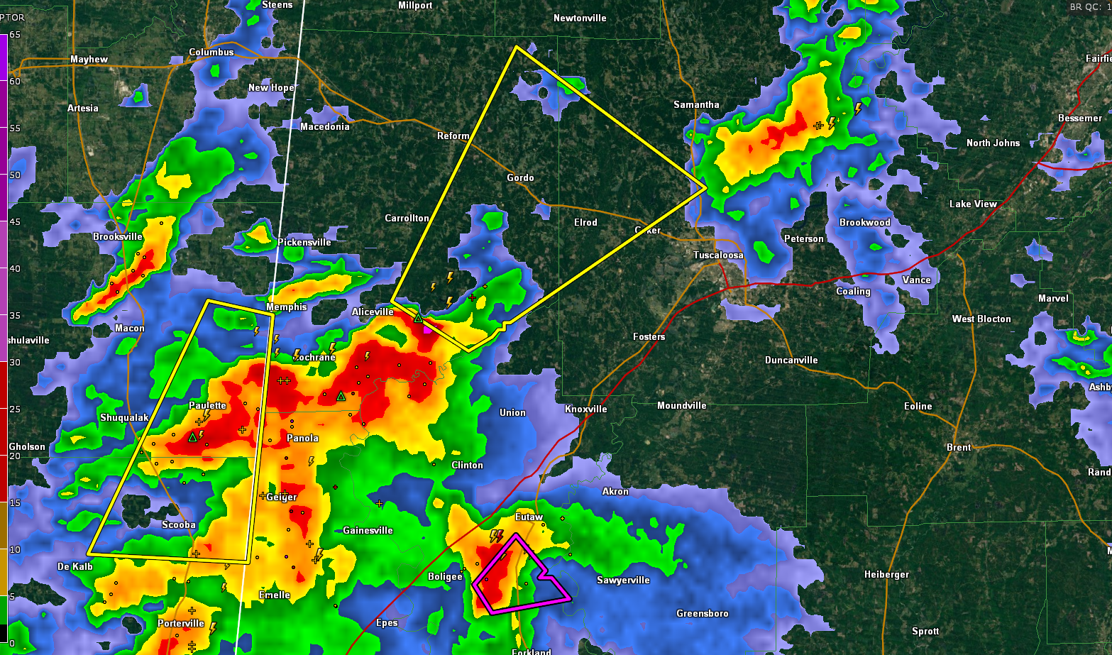
A very strong storm is southeast of Aliceville.
It will move across eastern Pickens and into western and northern Tuscaloosa County.
It will affect Gordo and Elord.
The warning does not include the Cities of Tuscaloosa or Northport or the University of Alabama.
Note the purple polygon to the south. That tornado warning is for Greene County. TIt will not be extended according to the NWS. That storm will move toward Akron and Moundville and will stay south og Tuscaloosa.
THE NATIONAL WEATHER SERVICE IN BIRMINGHAM HAS ISSUED A
* SEVERE THUNDERSTORM WARNING FOR…
WEST CENTRAL TUSCALOOSA COUNTY IN WEST CENTRAL ALABAMA…
EASTERN PICKENS COUNTY IN WEST CENTRAL ALABAMA…
* UNTIL 230 PM CDT.
* AT 140 PM CDT, A SEVERE THUNDERSTORM WAS LOCATED OVER JOHNSTON
LAKE, OR 7 MILES SOUTHEAST OF CARROLLTON, MOVING NORTHEAST AT 40
MPH.
HAZARD…60 MPH WIND GUSTS AND QUARTER SIZE HAIL.
SOURCE…RADAR INDICATED.
IMPACT…HAIL DAMAGE TO VEHICLES IS EXPECTED. EXPECT WIND DAMAGE
TO ROOFS, SIDING, AND TREES.
* LOCATIONS IMPACTED INCLUDE…
GORDO, REFORM, COKER, BENEVOLA, JOHNSTON LAKE, LAKE LURLEEN STATE
PARK, KIRK, PIONEER, BUHL, ECHOLA, LUBBUB AND ELROD.
Category: Alabama's Weather, ALL POSTS, Severe Weather
About the Author (Author Profile)
Bill Murray is the President of The Weather Factory. He is the site's official weather historian and a weekend forecaster. He also anchors the site's severe weather coverage. Bill Murray is the proud holder of National Weather Association Digital Seal #0001 @wxhistorianSubscribe
If you enjoyed this article, subscribe to receive more just like it.


