Flash Flood Watch for All of North Alabama Until 7:00 am Thursday
…FLASH FLOOD WATCH IN EFFECT THROUGH THURSDAY MORNING…
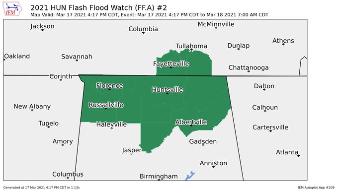
The National Weather Service in Huntsville has issued a
* Flash Flood Watch for portions of Alabama and southern middle
Tennessee, including the following areas, in Alabama, Colbert,
Cullman, DeKalb, Franklin AL, Jackson, Lauderdale, Lawrence,
Limestone, Madison, Marshall and Morgan. In southern middle
Tennessee, Franklin TN, Lincoln and Moore.
* Through Thursday morning
* Rainfall amounts around one to three inches have occurred across
the area over the last 24 hours and caused soils to become fairly
saturated. Further development of heavy showers and thunderstorms
with additional rainfall amounts of two to four inches across the
area is likely to cause instances of flash flooding through
tonight.
PRECAUTIONARY/PREPAREDNESS ACTIONS…
A Flash Flood Watch means that conditions may develop that lead to
Flash Flooding. Flash Flooding is a very dangerous situation. You
should monitor later forecasts and be prepared to take action should
Flash Flood Warnings be issued.
Do not enter or cross flowing water or water of unknown depth.
Category: Alabama's Weather, ALL POSTS, Severe Weather
About the Author (Author Profile)
Scott Martin is an operational meteorologist, professional graphic artist, musician, husband, and father. Not only is Scott a member of the National Weather Association, but he is also the Central Alabama Chapter of the NWA president. Scott is also the co-founder of Racecast Weather, which provides forecasts for many racing series across the USA. He also supplies forecasts for the BassMaster Elite Series events including the BassMaster Classic.Subscribe
If you enjoyed this article, subscribe to receive more just like it.


