EXPIRED Severe Thunderstorm Warning for Parts of Fayette, Lamar, Marion until 8:45 p.m.
Strong storms are moving into Northwest Alabama at this hour. There have been numerous reports of trees down across parts of Clay and Oktibbeha Counties in Northeast Mississippi with this storm.
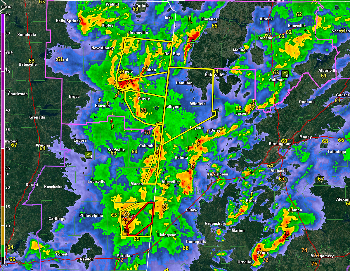
There is a new tornado warning for Kemper County MS for a storm near Scooba. This storm may lift into Pickens County, southern Sumter, and Greene Counties. We will be monitoring it. There is certainly some maximized low level shear downstream from this storm.
Folks near Aliceville, Gainesville, Geiger, and Carrollton should monitor this storm.
The National Weather Service in Birmingham has issued a
* Severe Thunderstorm Warning for…
Marion County in northwestern Alabama…
Northwestern Fayette County in west central Alabama…
Lamar County in west central Alabama…
* Until 845 PM CDT.
* At 746 PM CDT, severe thunderstorms were located along a line
extending from near Amory to 7 miles northwest of Bedford to near
Steens, moving northeast at 45 mph.
HAZARD…60 mph wind gusts.
SOURCE…Radar indicated.
IMPACT…Expect damage to roofs, siding, and trees.
* Locations impacted include…
Hamilton, Winfield, Fayette, Haleyville, Vernon, Sulligent, Guin,
Hackleburg, Brilliant, Glen Allen, Detroit, Beaverton, Gu-
Win, Weston, Bluff, Blooming Grove, Lamar County Airport, Brinn,
Lake Buttahatchee and Crews.
Category: Alabama's Weather, ALL POSTS, Severe Weather
About the Author (Author Profile)
Bill Murray is the President of The Weather Factory. He is the site's official weather historian and a weekend forecaster. He also anchors the site's severe weather coverage. Bill Murray is the proud holder of National Weather Association Digital Seal #0001 @wxhistorianSubscribe
If you enjoyed this article, subscribe to receive more just like it.


