Midday Nowcast: Rain is Back
Clouds returned to Alabama overnight, and rain and a few storms are moving into and through Alabama as a weak cold front approaches the state today.
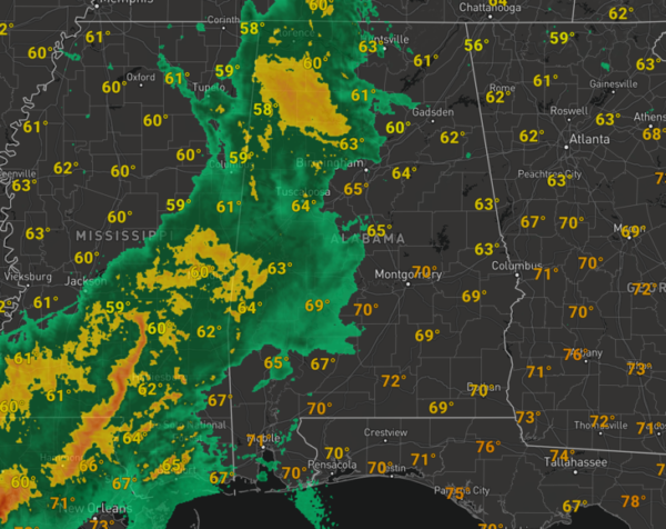
The main dynamic forcing with this feature is well to the north of Alabama, and severe storms are not expected, but don’t be surprised to hear some rumbles of thunder the rest of today. Temperatures this afternoon are in upper 60s and low to mid 70s for most locations. We will maintain the threat for passing showers through the overnight hours with lows in the upper 50s. For tomorrow, showers will remain possible, but it looks like a decent part of they will be dry. We note severe storms are possible across much of Mississippi tomorrow, but not for us in Alabama. Tomorrow will another mild day with highs in the 70s.
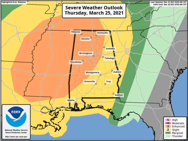
MORE SEVERE STORMS THURSDAY/THURSDAY NIGHT: A potent upper air trough will generate a deepening surface low west of Alabama, and will bring a risk of strong to severe thunderstorms back to the state by Thursday afternoon and Thursday night. SPC maintains an “enhanced risk” (level 3/5) for much of Alabama, as far east as Scottsboro, Pell City, Clanton, and Grove Hill. The rest of the state (East and South Alabama) is in a “slight risk” (level 2/5).
First, there remains quite a bit of difference in the global model output for this system so there remains a fair amount of uncertainty as far as how this event unfolds.
The GFS shows the surface low very close to us, and provides a large mass of rain during the morning, limiting instability. In that case there would be a narrow window for severe storms along the cold front Thursday evening/night. This is the best scenario…
However the European model is much more bullish with overall setup and possible threats allowing for surging instability values during the day, due to the lack of morning rain/storms. A deep surface low sets up northwest of the state with strong wind fields aloft, high shear values, and steep lapse rates, providing an environment favorable for severe thunderstorms with large hail, damaging winds, and tornadoes. And, a few strong/violent tornadoes can’t be ruled out, if this is the scenario which occurs.
As far as timing, the main window for Alabama looks to be Thursday afternoon, evening, and night. Of course we will have a better handle on the threats and timing of the event over the next couple of days. Please make sure you pay attention to future forecasts in the coming days and go ahead and make sure all parts of your severe weather safety plan are ready in case you have to act and be in a position to hear severe weather warnings Thursday.
Severe storms or not, rainfall could become an issue as from now through the weekend as rain amounts across the state could be signifiant. A flash flood watch is in effect for Choctaw, Clarke, Washington, Mobile, and Baldwin counties in Southwest Alabama, where totals will be in the 5-7 inch range. The rest of the state will see amounts generally between 2-4 inches. So if you live in flood prone areas, just be prepared to act.
BEACH FORECAST CENTER: Get the latest weather and rip current forecasts for the beaches from Fort Morgan to Panama City on our Beach Forecast Center page. There, you can select the forecast of the region that you are interested in visiting.
WORLD TEMPERATURE EXTREMES: Over the last 24 hours, the highest observation outside the U.S. was 112.1F at Birni-N’Konni, Niger. The lowest observation was -77.1F at Concordia, Antarctica.
CONTIGUOUS TEMPERATURE EXTREMES: Over the last 24 hours, the highest observation was 93F at Falcon Lake, TX. The lowest observation was -23F at Peter Sinks, UT.
WEATHER ON THIS DATE IN 1913: A vicious tornado hit the city of Omaha, NE. The tornado struck during the late afternoon on Easter Sunday, and in just twelve minutes cut a swath of total destruction five miles long and two blocks wide across the city killing 94 persons and causing 3.5 million dollars property damage.
Category: Alabama's Weather, ALL POSTS
About the Author (Author Profile)
Macon, Georgia Television Chief Meteorologist, Birmingham native, and long time Contributor on AlabamaWX. Stormchaser. I did not choose Weather, it chose Me. College Football Fanatic. @Ryan_StinnetSubscribe
If you enjoyed this article, subscribe to receive more just like it.


