Significant Severe Weather Threat Less Than 24 Hours Away; A Few Strong Storms Could Occur Before Sunrise
The Storm Prediction Center has introduced a Level 1 Marginal Risk for severe storms on their Day One Severe Weather Outlook for a good portion of North/Central Alabama which goes from now until 7:00 am Thursday morning for the potential of isolated damaging wind gusts and quarter size hail during the pre-dawn hours up to sunrise on Thursday morning. This includes the cities of Florence, Russellville, Hartselle, and Cullman in North Alabama, and for Hamilton, Jasper, Birmingham, Hoover, Talladega, Tuscaloosa, Clanton, Alexander City, Demopolis, Selma, and Montgomery.
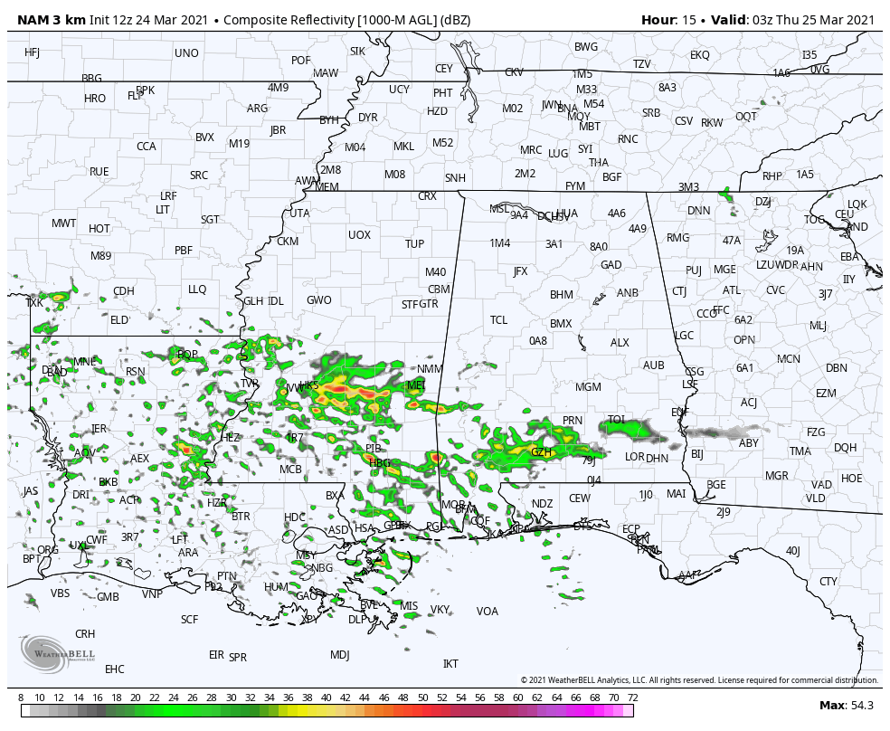 Simulated radar from 10 pm tonight through 12 pm Thursday (12z NAM 3k).
This morning round of storms will be associated with a warm front that will push northward across the area starting late tonight and should be out of the northern parts of the area by 8 am; however, the atmosphere will be in the process of destabilizing after the front passes, so the risk of severe storms will continue through noon. Once we get to midday, that is when we really need to start watching for developing storms over the western half of the area.
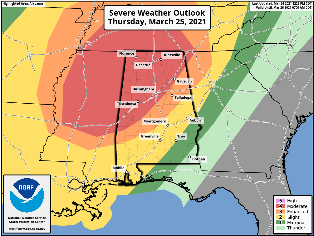
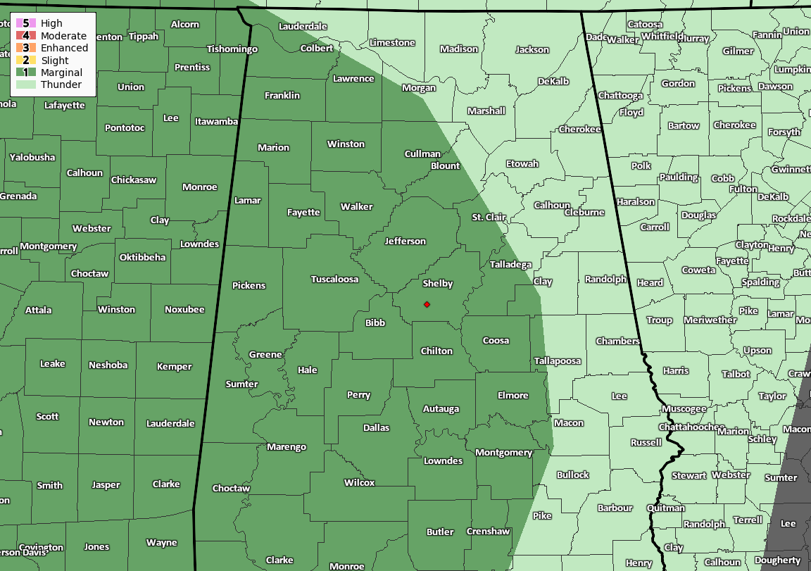
The SPC has a Level 4 Moderate Risk for severe storm up for locations along and west of the I-59 corridor, which includes the cities of Florence, Russellville, Decatur, Athens, Hartselle, Cullman, Huntsville, Guntersville, Scottsboro, and Rainsville in North Alabama, and Hamilton, Tuscaloosa, Demopolis, Birmingham, and Gadsden.
A Level 3 Enhanced Risk for severe storms is up for locations east of the Moderate Risk, which includes the cities of Anniston, Talladega, Clanton, and Selma. A Level 2 Slight Risk is up east of that, which includes Alexander City, Auburn, Troy, and Montgomery. A Level 1 Marginal Risk is up for the extreme southeastern parts of the area, including Eufaula.
Strong tornadoes, damaging winds up to and exceeding 70 mph, and golf ball size hail will be possible for those in the Moderate Risk area. The Enhanced and Slight Risk areas will have the potential for tornadoes, damaging winds up to 60 mph, and quarter size hail, with a strong tornado possible in the Enhanced Risk. The Marginal Risk area will have a minimal threat of isolated damaging winds up to 60 MPH and a brief tornado or two.
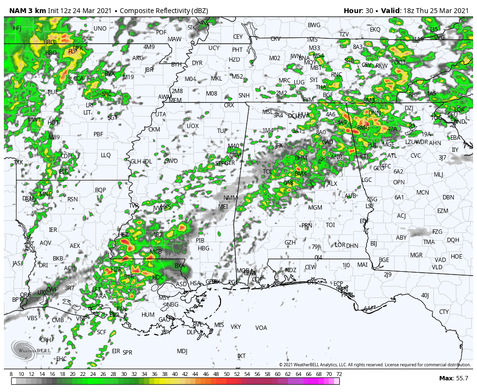 Simulated radar from 1 pm Thursday to 12 am Friday (12z NAM 3k).
The main window for strong to severe storms across the Moderate and Enhanced Risk area will be from 12 pm to 10 pm from west to east, and from 6 pm to midnight west to east for the Slight and Marginal Risk areas. The activity will start off as the potential for discrete supercell thunderstorms that may produce tornadoes, some of which could be of the strong long-track variety, over the Moderate and Enhanced risk areas, but those will eventually dissipate, and we’ll become focused on the main squall line which will move in later and sweep across the entire area. The good news is that the line will be weakening as it will lose its vertical profile and shift to a more slanted orientation as the better dynamics race farther away from the area.
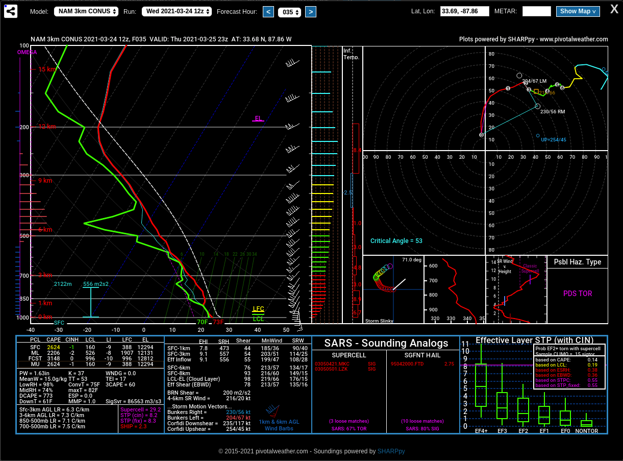
Forecast sounding valid for Fayette (Fayette Co.) at 6 pm Thursday.
The latest forecast sounding from the 12z NAM 3k model run centered around Fayette (Fayette Co.) at 6 pm Thursday shows very impressive values that would warrant a particularly dangerous situation (PDS) tornado hazard type. Instability will be very high around 2,600 J/kg, while the storm relative helicity will be around 530 m2/s2 in the surface to 3 km layer. Shear in the surface to 6 km layer will be screaming at 76 knots. There will be plenty of fuel to get those storms going and organized, and plenty of spin in the atmosphere to get those storms to rotate.
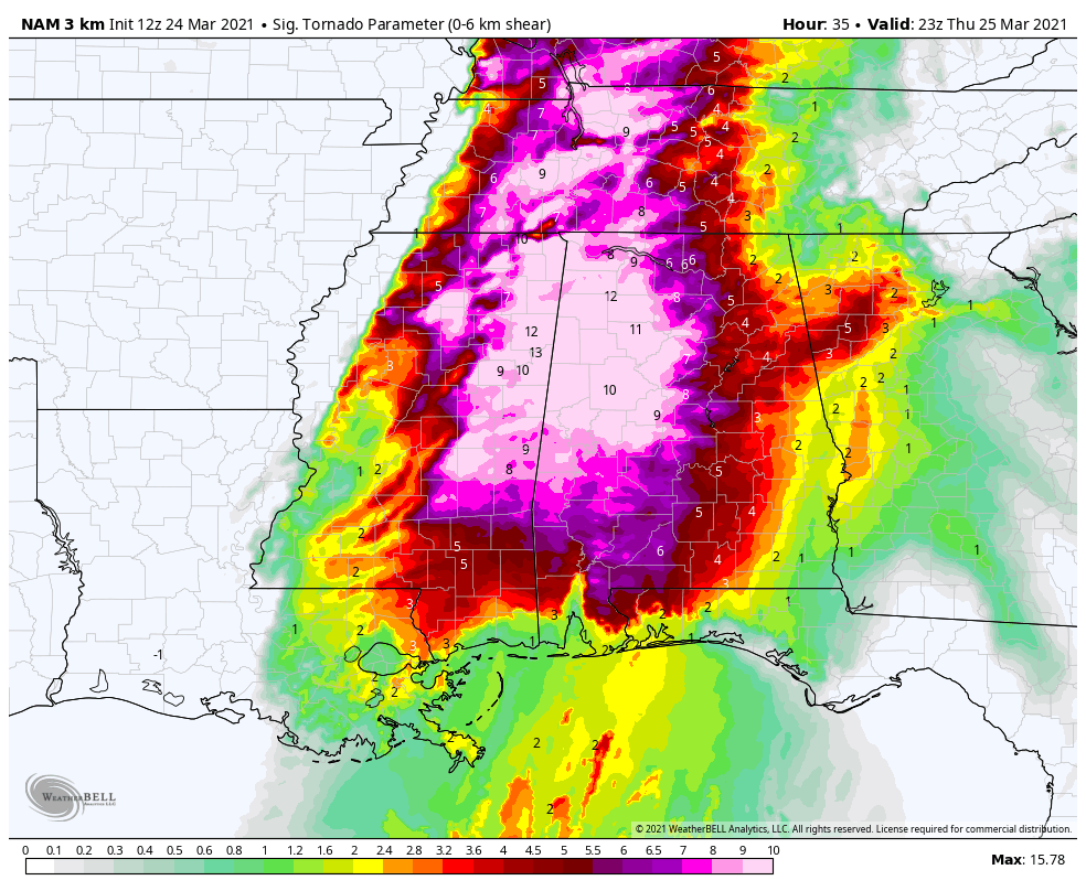
STP values valid at 6 pm Thursday.
Significant Tornado Parameter (STP) values are topping out off the charts around 10 to 12 in the northwestern quarter of Central Alabama. While not clearly shown on the supplied graphic, somewhere in that sector the values max out at 15. A majority of significant tornadoes (F2 or greater damage) have been associated with STP values greater than 1, while most non-tornadic supercells have been associated with values less than 1. These values are much higher than what we saw on the models for the last severe weather event just one week ago.
Get your planning, gathering of your supplies, and readying of your safe place completed by tonight at the latest. Be sure that those safe places have helmets and hard-toed shoes for each person, and a few loud noise-makers (bullhorn or small air horns) to get someone’s attention just in the event if you become trapped. Also, be sure to know where your county is located on a map of Alabama, and become familiar with the counties that surround where you are. That way, when you here or see that a county close by goes under a warning, you will have that much more notification in advance if a warning is issued for your location down the road.
You can find plenty of tornado safety information at the Severe Weather Awareness page on the NWS Mobile website.
Category: Alabama's Weather, ALL POSTS, Severe Weather
About the Author (Author Profile)
Scott Martin is an operational meteorologist, professional graphic artist, musician, husband, and father. Not only is Scott a member of the National Weather Association, but he is also the Central Alabama Chapter of the NWA president. Scott is also the co-founder of Racecast Weather, which provides forecasts for many racing series across the USA. He also supplies forecasts for the BassMaster Elite Series events including the BassMaster Classic.Subscribe
If you enjoyed this article, subscribe to receive more just like it.


