

Elevated Storms for Now, Severe Risk Will Increase Greatly By Early Afternoon
This latest Mesoscale Discussion from the Storm Prediction Center confirms that these storms are remaining elevated at the moment, but the weather will deteriorate and severe storms capable of producing large tornadoes will be possible by the early afternoon. Here is the text from the discussion:
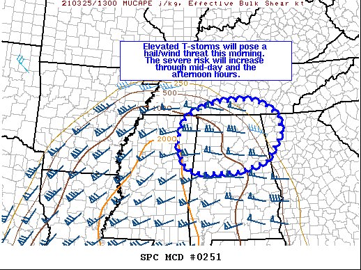
SUMMARY… Elevated thunderstorms will pose a hail and wind risk through the late morning hours across the northern AL region. The severe potential will increase during the early afternoon and into the evening hours as additional surface-based storms develop.
DISCUSSION… Mid-morning regional radar shows a swath of elevated convection ongoing from northeastern MS into northern AL associated with a zone of strong warm air advection between 850-700 mb along the synoptic warm front. Morning observed and forecast soundings indicate these storms are mostly elevated and deep-layer flow oriented along the axis of initiation suggest a clustered storm mode may continue in the near-term. Although this convection is on the fringes of the better instability (500-1000 J/kg MUCAPE with higher values to the south/southwest), deep-layer shear is very favorable for organized convection with 60-70 knots of effective bulk shear. While storm interactions may limit the coverage of severe convection for the next couple of hours, a few strong to severe storms are possible and will primarily pose a wind/hail risk for the next 1-2 hours.
The severe potential is expected to increase across this region by mid-day and through the afternoon/evening hours. Partly cloudy skies and a northward flux of upper 60s/low70s dewpoints behind this early-morning convection will allow for diurnal heating/destabilization that will support surface-based convection (and a higher severe threat). Although a watch is not anticipated in the near-term, a watch will be needed later today.
Category: Alabama's Weather, ALL POSTS, Severe Weather
About the Author (Author Profile)
Scott Martin is an operational meteorologist, professional graphic artist, musician, husband, and father. Not only is Scott a member of the National Weather Association, but he is also the Central Alabama Chapter of the NWA president. Scott is also the co-founder of Racecast Weather, which provides forecasts for many racing series across the USA. He also supplies forecasts for the BassMaster Elite Series events including the BassMaster Classic.Subscribe
If you enjoyed this article, subscribe to receive more just like it.


