Latest Mesoscale Discussion Continues to Show Need for Tornado Watch by Noon
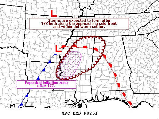
SUMMARY… Storms are expected to form over the next couple of hours over central and western Mississippi. Supercells are likely, with tornado threat increasing as cells mature and move northeast toward Alabama. Watch will be issued soon.
DISCUSSION… Visible imagery and surface obs indicate the air mass continues to destabilize with areas of heating, as temperatures rise into the mid 70s F over the warm sector. This is sufficiently warm for surface-based parcels. Indications are that cells may develop both ahead of the cold front due to a very moist warm sector, and along the front itself. Deep-layer shear is expected to strengthen storms, which will gain intensity and tornado potential as they mature and continue northeastward across MS and into AL. The threat may extend into southern TN as well, once the warm front lifts there.
Category: Alabama's Weather, ALL POSTS, Severe Weather
About the Author (Author Profile)
Scott Martin is an operational meteorologist, professional graphic artist, musician, husband, and father. Not only is Scott a member of the National Weather Association, but he is also the Central Alabama Chapter of the NWA president. Scott is also the co-founder of Racecast Weather, which provides forecasts for many racing series across the USA. He also supplies forecasts for the BassMaster Elite Series events including the BassMaster Classic.Subscribe
If you enjoyed this article, subscribe to receive more just like it.


