

Flash Flood Watch for Much of North Alabama Until 7:00 pm Sunday Evening
…FLASH FLOOD WATCH IN EFFECT FROM 7 AM CDT THIS MORNING THROUGH SUNDAY EVENING…
The National Weather Service in Huntsville has issued a
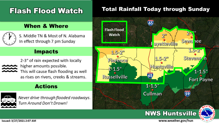
* Flash Flood Watch for portions of Alabama and southern middle Tennessee, including the following areas, in Alabama, Colbert, Franklin AL, Jackson, Lauderdale, Lawrence, Limestone, Madison and Morgan. In southern middle Tennessee, Franklin TN, Lincoln and Moore.
* From 7 AM CDT this morning through Sunday evening
* Multiple periods of thunderstorms are expected today into Sunday. Thunderstorms today into this evening will be capable of 1 to 2 inches of rainfall in a short period of time. Then, a line of thunderstorms will move through the area late tonight into Sunday morning, again capable of 1 to 2 inches of rainfall. Due to recent rainfall events, soils remain quite saturated and susceptible to excessive runoff and flash flooding.
PRECAUTIONARY/PREPAREDNESS ACTIONS…
A Flash Flood Watch means that conditions may develop that lead to Flash Flooding. Flash Flooding is a very dangerous situation. You should monitor later forecasts and be prepared to take action should Flash Flood Warnings be issued.
Category: Alabama's Weather, ALL POSTS, Severe Weather
About the Author (Author Profile)
Scott Martin is an operational meteorologist, professional graphic artist, musician, husband, and father. Not only is Scott a member of the National Weather Association, but he is also the Central Alabama Chapter of the NWA president. Scott is also the co-founder of Racecast Weather, which provides forecasts for many racing series across the USA. He also supplies forecasts for the BassMaster Elite Series events including the BassMaster Classic.Subscribe
If you enjoyed this article, subscribe to receive more just like it.


