Severe Thunderstorm Watch May Be Issued Within the Next Couple of Hours
SPC indicates in this latest Mesoscale Discussion that there may be bowing segments that will produce gusty winds and hail, along with a small threat of a brief spin-up tornado or two. A Severe Thunderstorm Watch may be needed over the next couple of hours.
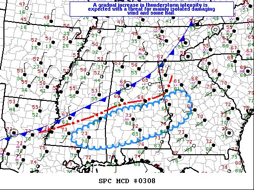
SUMMARY… Thunderstorms may become capable of producing mainly isolated damaging wind and hail this afternoon. A brief tornado also cannot be ruled out.
DISCUSSION… As of midday thunderstorms continue developing along a convective outflow boundary that extends from northern GA southwest through central AL and into southern MS. This boundary will continue moving slowly southeast the remainder of the afternoon. Satellite imagery indicates partial clearing in the warm sector where dewpoints are generally in the mid to upper 60s F but with low 60s with eastward extent into GA. The 12Z RAOB data show weak mid-level lapse rates, but as the moist boundary layer destabilizes, MLCAPE will increase to around 500 J/kg across central GA and up to 1500 J/kg along southern portions of the Gulf Coast states. While winds in the surface to 700 mb layer will remain weak to modest, mid-upper flow will gradually increase as the upstream trough amplifies, supporting effective bulk shear from 50 to 55 kt. This suggests a few organized storms may occur including bowing segments and possibly some supercell structures with isolated damaging wind the primary threat, though some hail will also accompany the stronger updrafts.
Category: Alabama's Weather, ALL POSTS, Severe Weather
About the Author (Author Profile)
Scott Martin is an operational meteorologist, professional graphic artist, musician, husband, and father. Not only is Scott a member of the National Weather Association, but he is also the Central Alabama Chapter of the NWA president. Scott is also the co-founder of Racecast Weather, which provides forecasts for many racing series across the USA. He also supplies forecasts for the BassMaster Elite Series events including the BassMaster Classic.Subscribe
If you enjoyed this article, subscribe to receive more just like it.


