Alabama Weather Update at 8 p.m.: Watch Canceled, But Threat is Not Over for the Night

The thunderstorm activity over Alabama has diminished considerably in the past 90 minutes as we lose the heating of the day.
The severe thunderstorm watch has been canceled for Alabama, but the threat is not over for the night.
There is a short line of strong to severe storms over southwestern Tennessee and northeastern Mississippi. These storms continue to produce hail and there is a tornado warning in effect for portions of Union, Lee, and Pontotoc Counties. The most dangerous part of the storm is near Blue Spring, MS. It also has hail that is two inches in diameter, or about the size of hen’s eggs. These storms should weaken as they move further eastward into drier air, but the northeastern Mississippi could hold together until it gets into Northwest Alabama. We will be tracking.
Back to the west, severe storms continue from Central Mississippi into northern Louisiana, and northeastern Texas. These storms will work into western Alabama after 11 p.m. or so. The airmass over Mississippi is much more unstable with CAPE values over 3,000 j/kg but these storms should weaken as they push deeper into our state with less instability and bulk wind shear the further east and north you go.
Meanwhile, as the upper trough to our northwest rotates around, wind fields over eastern Mississippi and western Alabama will increase. A strong squall line will form near the Mississippi River after midnight and will gradually overtake the convection in front of it, and a QLCS (Quasi-Linear Convective System) may form and push across Mississippi toward Alabama. If it does form, this could be supportive of an organized wind damage threat into Alabama.
The line of storms will push rapidly across Alabama from west to east starting around 6-7 a.m. It should reach I-65 around 8 a.m. and weaken thereafter.
There will be a significant damaging wind threat in the moderate risk and enhanced risk areas, as far east as I-65.
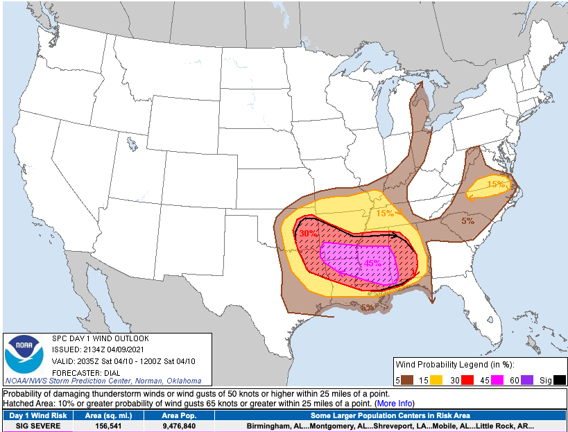
The hatched area is where significant damaging winds of greater than hurricane force could occur. The percentages are the probability of such damaging winds within 25 miles of a point.
Category: Alabama's Weather, ALL POSTS, Severe Weather
About the Author (Author Profile)
Bill Murray is the President of The Weather Factory. He is the site's official weather historian and a weekend forecaster. He also anchors the site's severe weather coverage. Bill Murray is the proud holder of National Weather Association Digital Seal #0001 @wxhistorianSubscribe
If you enjoyed this article, subscribe to receive more just like it.


