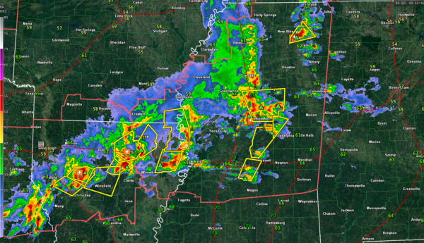
Storms Gaining Strength over Eastern Mississippi; Could Reach Western Alabama Within the Hour
Storms have really intensified over Eastern Mississippi over the past 45 minutes.
They are now about 25-35 miles west of the Alabama border. Moving east at 40 mph, they could reach parts of Lamar and Pickens Counties before 9:30, and parts of Marion, Frankin, Colbert, and Lauderdale Counties perhaps a little earlier.
Numerous severe thunderstorm warnings are in effect along the line, mainly for hail, but damaging winds are also a threat.
Dewpoints are lower over Northwest Alabama, so hopefully, northern portions of the line will weaken as they move into Alabama. Dewpoints are in the lower 60s over the parts of West Alabama that are further south, so the storms could hold together there.
There is a tornado warning now for parts of Rankin and Scott Counties in Central Mississippi for a potential tornado in a storm along I-20 near Morton, Mississippi. There is still some decent low-level helicity of West Central Alabama, so these storms will have to be watched for the potential for isolated tornadoes as well the hail and damaging wind threat.
We continue to watch developments back in Oklahoma, where strong storms there could form a second powerful squall line that rolls into Alabama well after midnight. A severe thunderstorm watch has just been posted for portions of Arkansas, Texas, and Oklahoma until 2 a.m.
Category: Alabama's Weather, ALL POSTS, Severe Weather


