Strong to Severe Storms Possible Today; Very Nice on Sunday
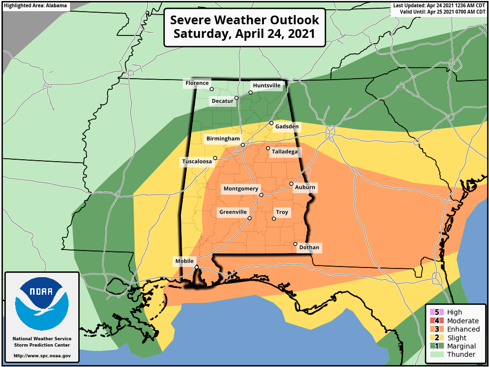
SPC UPDATE: The latest update from the Storm Prediction Center has an Enhanced Risk, which is level 3/5, up for much of the southern half of Central Alabama, including the cities of Hoover, Clanton, Selma, Talladega, Alexander City, Auburn, Montgomery, Troy, and Eufaula. Nearly the rest of Central Alabama is in the level 2/5 Slight Risk, which covers the cities of Demopolis, Tuscaloosa, Birmingham, Gadsden, and Anniston. The level 1/5 Marginal Risk is up for the extreme northern parts of Central Alabama and for much of North Alabama which includes the cities of Hamilton, Decatur, Hartselle, Cullman, Scottsboro, Rainsville, and Guntersville.
TODAY & SUNDAY: A good soaking rain will continue through sunrise for much of the area before activity looks to become more scattered on the backside of this first wave of rain and storms. The low-level wind fields will continue to strengthen over the next several hours over the southern half of the area that will bring a risk of severe storms with damaging winds and the potential for a couple of tornadoes with this first wave.
Much of the area will get a break from rain activity as coverage becomes more scattered in nature as it moves to the east and southeast. By midday, much of the activity will be confined to South Alabama and the extreme southeastern parts of Central Alabama. More scattered storms are expected to form throughout the afternoon and evening hours and move eastward through the area. This second round of storms will bring a risk of severe storms to the area in a main window from noon to 9 pm, with the risk ending for the northwestern parts of the area by 4 pm, for the northeastern and southwestern parts including the I-59 corridor by 7 pm, and for the southeastern parts by 9 pm. Damaging winds, large hail, and a couple of tornadoes will be possible with this round.
The rain comes to an end by midnight for all of North/Central Alabama after the cold front moved through and drier air moves in behind it, leaving us with mostly cloudy skies. Today’s highs look to reach the mid-70s to the lower 80s across the area, with overnight lows falling into the upper 40s to the upper 50s.
Sunday will be a very nice day with clearing skies and mild temperatures. Highs will be in the 70s across the area.
NEXT WEEK: Monday will be a warmer day with near-maximum sunshine. Highs reaching the lower to mid-80s. Tuesday will be even warmer and remaining dry with highs reaching the mid-80s for most locations. Wednesday will be a warm day as well, but we’ll have clouds start to move in from the west ahead of our next system. We’ll stay dry and highs will be in the lower to mid-80s.
Rain and storms will begin to enter the northwestern parts of the area during the morning hours on Thursday ahead of a cold front. A surface low will be moving northeastward along the front, and it will stay north of the state. There will be some instability involved ahead of the front in the warm sector, so we can’t rule out a strong storm at this point. It is too early to know at this point if we’ll have any severe weather, but we’ll stay on top of it after today’s threat. Highs will be in the mid-70s to the lower 80s.
We may still be dealing with some left-over light rain or drizzle on the backside of the departing system on Friday along with a mostly cloudy sky. Highs will be much cooler, reaching the upper 60s to the upper 70s.
Category: Alabama's Weather, ALL POSTS, Severe Weather, Weather Xtreme Videos
About the Author (Author Profile)
Scott Martin is an operational meteorologist, professional graphic artist, musician, husband, and father. Not only is Scott a member of the National Weather Association, but he is also the Central Alabama Chapter of the NWA president. Scott is also the co-founder of Racecast Weather, which provides forecasts for many racing series across the USA. He also supplies forecasts for the BassMaster Elite Series events including the BassMaster Classic.Subscribe
If you enjoyed this article, subscribe to receive more just like it.


