

Another Watch Coming Soon for Parts of North and Central Alabama
Multiple concerns now for severe weather over Alabama. This morning’s convection may be forming into a mesoscale convective system that will produce damaging wind, hail, and isolated tornadoes.
Thunderstorms developing over Louisiana and Mississippi will intensify and move eastward and produce the threat of tornadoes and widespread wind damage event later today.
They say that a watch will likely be issued soon for a portion of this area.
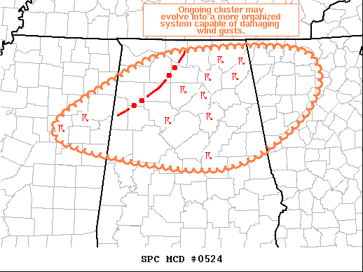
Mesoscale Discussion 0524
NWS Storm Prediction Center Norman OK
0903 AM CDT Tue May 04 2021
Areas affected…Far Northeast/East-Central MS…Northern/Central
AL…Northwest GA
Concerning…Severe potential…Watch likely
Valid 041403Z – 041600Z
Probability of Watch Issuance…80 percent
SUMMARY…Ongoing storm cluster may evolve into a more organized
linear system capable of damaging wind gusts and isolated hail.
Trends are being monitored for likely watch issuance.
DISCUSSION…Western edge of the ongoing cluster of thunderstorms
from northeast MS across northern AL is beginning to show more
forward propagation, suggestive that a cold pool may becoming more
established/organized. This increased forward motion may also be
tied to the ascent associated with the shortwave trough moving into
AR. In either case, the downstream environment supports continued
development. 12Z BMX sounding sampled a deep, moist boundary layer
and 100-mb mean mixing ratio over 15 g/kg. Ongoing storms have
likely reduced the maximum lapse rate between 2-6 km, which was over
7 deg C per km on the sounding, but the moist low-levels still
result moderate buoyancy (i.e. MLCAPE around 1500 J/kg).
Whether or not this ongoing cluster is able to evolve into a linear
MCS remains uncertain, but trends are indicating this potential is
increasing. Additionally, interaction between the more
eastward-moving storms on the western edge of the cluster with
leading storms could result in localized updraft intensification.
This intensification would likely promote strong downdrafts and
occasional hail. Convective trends are being monitored closely for
watch issuance.
..Mosier/Grams.. 05/04/2021
Category: Alabama's Weather, ALL POSTS, Severe Weather
About the Author (Author Profile)
Bill Murray is the President of The Weather Factory. He is the site's official weather historian and a weekend forecaster. He also anchors the site's severe weather coverage. Bill Murray is the proud holder of National Weather Association Digital Seal #0001 @wxhistorianSubscribe
If you enjoyed this article, subscribe to receive more just like it.


