7 a.m. Update on Alabama’s Weather Situation: Severe Weather Threat This Afternoon and Tonight
A quick update on this Sunday morning about the severe weather situation for later today across the state.
The video will be up by 7:45 a.m.
Not much has changed in thinking about today’s severe weather threat across the Mid-South and into Alabama tonight.
A developing surface low is over Missouri this morning. It will move northeast through the Ohio Valley today, dragging a cold front through the Southeast.
S=Stroms will reach the Northwest Corner of Alabama by 1 p.m. or so, but we don’t expect those to be severe. Storms will be developing over northern Louisiana and Arkansas about the same time though and those will become severe, with a significant threat of large hail and damaging winds, and a fairly standard threat of tornadoes.
We will be watching the storms over northern Mississippi between 4-6 p.m. as they might produce tornadoes, but the low-level jet will be weakening as the storms move towards Alabama. There is a small chance a couple of tornadoes could menace the northwestern corner of the state around 5-6 p.m., but the threat is low.
The storms will have the chance to be severe as they move into northwestern Alabama between 5-7 p.m., watching mainly for damaging winds and hail. The storms will slowly weaken but will produce heavy rain through the night as they work their way southeast. The storms should be south of I-59 by 3 a.m. with some lingering rain until around sunrise.
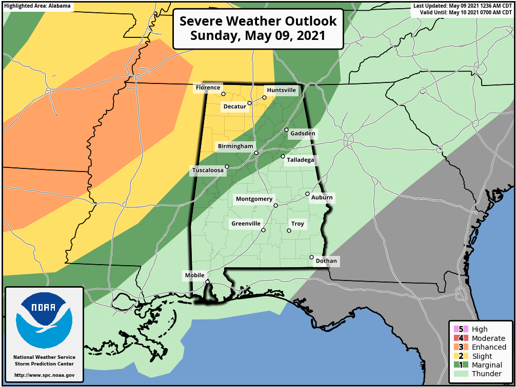
The SPC has a slight risk (level 2/5) for some Northwest Alabama counties with another couple of rows of counties to the southeast of that in a marginal risk (level 1/5). Note that enhanced risk back to the west over Louisiana, Arkansas, Mississippi, and Tennessee. That corresponds to a strong threat of some large to very large hail and a higher threat of damaging winds. That is where the 5% tornado risk is as well. The threat will be between 4-11 p.m.
A wind advisory has been issued for the Tennessee Valley COunties for today and tonight due to gradient winds that could gust to 30-35 mph at times. Winds will gust to 25 mph today and tonight outside the advisory area across North Central and Central Alabama.
Just stay weather aware later today and tonight. We will have the latest throughout the day and overnight tonight.
Category: Alabama's Weather, ALL POSTS, Severe Weather
About the Author (Author Profile)
Bill Murray is the President of The Weather Factory. He is the site's official weather historian and a weekend forecaster. He also anchors the site's severe weather coverage. Bill Murray is the proud holder of National Weather Association Digital Seal #0001 @wxhistorianSubscribe
If you enjoyed this article, subscribe to receive more just like it.


