Sunday Weather Xtreme: Happy Mother’s Day! Severe Weather Threat This Afternoon and Tonight Though
HAPPY MOTHER’S DAY! Thanks, Mom for all you do! It’s setting up to be a warm Mother’s Day across the state, with an increasing chance of storms as we go into the afternoon and evening. The possibility of severe weather headlines this forecast package as we move deeper into May when things should be calming down. High pressure is going to put its foot down by week two and put the kibosh on the showers and storms that will wear out their welcome this week. Let’s dig into the details.
WE’RE STARTING OFF THE MORNING in the middle and upper 50s across the area as moisture levels edged by a bit overnight. Clouds have come and gone through the overnight hour, but most areas will enjoy at least some sunshine this morning. Winds will begin to pick up shortly in response to surface low pressure over Missouri. They will gust to 25 mph at times today and tonight, even into early Monday morning. Wind advisories have been posted for the Tennessee Valley.
Temperatures will be on the increase, along with moisture. Highs will top out in the lower and middle 80s. Dewpoints will be climbing into the lower 60s, so you will feel the humidity.
MEANWHILE…An upper-level disturbance will be pushing east, propelling that surface low eastward through the Ohio River Valley. A cold front will be near Texarkana by Lunch and near Memphis by Dinner. It will be near Jasper by breakfast and will be vacationing along the beaches of Alabama and Northwest Florida by Tuesday morning. The front will hang around for a couple of days before high pressure over the Midwest sends it packing for Havana.
BIG STORMS will fire over the Arklatex though this afternoon, where CAPE values will be approaching 4,000 joules/ kg! There will be a small threat of tornadoes from Northeast Texas to western Kentucky, including the Northwest Corner of Alabama later today and tonight. The bigger threat will be damaging winds, with the threat edging into Northwest Alabama. The biggest threat will be hail over Northeast Texas, Arkansas, and the Shreveport area of Northwest Louisiana.
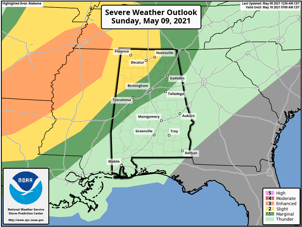
ALABAMA’S STORMS: A few showers and storms will reach NW Alabama by mid-afternoon. We will be watching those storms to the west over Mississippi and Tennessee, as they could be producing tornadoes. By late afternoon, instability values will be between 750-1,250 joules/kg over the Northwest corner of the state. A tornado could flirt with the Quad Cities area of Florence, Muscle Shoals, Tuscumbia, and Sheffield in the 4-7 p.m. time frame. We will then monitor these storms are they congeal into a line of storms and push southeastward. These storms should weaken with time, but there will continue to be a threat of damaging winds and hail as it pushes southeastward overnight. We can’t rule out a tornado over northwestern portions of the state. The SPC has northwestern Alabama northwest of a line from Reform to Berry to Hanceville to Arab and Gurley outlooked for a slight chance (level 2/5) with a marginal risk (level 1/5) down to I-20. The threat timing is from 4 p.m. this afternoon until 11 p.m. tonight. The storms will push southeast of Birmingham by midnight, but a second wave may move in from Mississippi during the overnight hours. They are not expected to become severe, but as we always say in Alabama when it comes to storms, expect the unexpected. Stay tuned.
RAINFALL: Rain amounts should average between 1 and 1.5 inches overnight. This could be heavy enough to cause some local flooding given our recent rains.
MONDAY: Skies will remain mostly cloudy with a leftover chance of showers and storms. It will be breezy into the early morning. Highs will be in the 70s.
LINGERING RAIN/STORM CHANCES: A moist flow and disturbances will keep us in shower and thunderstorm chances on Tuesday and Wednesday before a secondary front pushes all that moisture out of here for Thursday. Thursday will see clearing skies with just a leftover shower possible.
COOL: Well, it’s cool if you like cool temperatures. Highs Tuesday, Wednesday, and Thursday will struggle to get out of the 60s. They likely will, but low 70s will be the best most areas see. Low will fall back toward 50F.
WEEKEND: High pressure will take control of our weather just in time for a beautiful weekend. A warm spring sun will push highs back to near 80F on Saturday, with lower 80s by Sunday.
BEACHCAST: The good news is that today will be a nice day along the beautiful beaches of Alabama and Northwest Florida. Then things will go downhill through Thursday with plenty of rain and storms. High pressure will build in just in time for the weekend. Highs will be in the 79-83F range through the week, so not bad at all. Lows will be in the upper 60s and lower 70s through midweek, but fall back into the less humid lower 60s into the weekend. Water temperatures have warmed back into the mid 70s.
Click here to see the Beach Forecast Center page.
DANCING WITH THE STATS: Bozeman MT established a new record rainfall for the state yesterday after 1.22 inches fell.
WEATHERBAND: The American Meteorological Society has created a club for all of us! The weather enthusiasts of the world! You will connect with weather enthusiasts and experts alike. Special Weather Band items will identify you with the community. You’ll get special discounts on WeatherWise magazine and other merchandise as well as a special newsletter! Join today! https://amsweatherband.org/index.cfm/weatherband/membership/
ADVERTISE WITH US: Deliver your message to a highly engaged audience by advertising on the AlabamaWX.com website. The site enjoyed over 28 MILLION page views in the past 12 months. Don’t miss out! We can customize a creative, flexible, and affordable package that will suit your organization’s needs. Contact me, Bill Murray, at (205) 687-0782, and let’s talk.
WEATHERBRAINS: This week, the panel will entertain the famous Daryl Herzmann, of NWS Chat fame! Check out the show at www.WeatherBrains.com. You can also subscribe on iTunes. You can watch the show live at live.bigbrainsmedia.com or on James’ YouTube Channel You will be able to see the show on the James Spann 24×7 weather channel on cable or directly over the air on the dot 2 feed.
ON THIS DATE IN 2003: Veteran television meteorologist Gary England of KWTV in Oklahoma City said that it was the first time in thirty years on air that he was actually scared. The frightening situation came as a menacing tornado was bearing down on the Oklahoma City metro area just after 10 p.m. As his team of storm trackers radioed reports that the tornado was very near the television station, England ordered everyone out of the studio. He said that he realized that if the tornado struck the studio, he would probably die. It was then that he made the break for the station’s designated safe room, never missing a beat as he joined the rest of the staff in a room like a “sardine can with too many sardines.” Fortunately, the tornado passed without serious damage to the station. Other areas of Oklahoma City were not as lucky as the long-lived supercell thunderstorm produced a tornado that hopped and skipped across the northwestern and northern parts of the metro area. The storm would continue to produce tornadoes along a nearly continuous path paralleling the Turner Turnpike all the way to southern sections of Tulsa. The town of Stroud, OK, hard-hit during the May 3, 1999 outbreak was again a target, suffering heavy damage. An elderly man in Oklahoma City died from injuries sustained during the terrifying tornado. Follow my weather history tweets on Twitter. I am @wxhistorian at Twitter.com.
Category: Alabama's Weather, ALL POSTS, Severe Weather
About the Author (Author Profile)
Bill Murray is the President of The Weather Factory. He is the site's official weather historian and a weekend forecaster. He also anchors the site's severe weather coverage. Bill Murray is the proud holder of National Weather Association Digital Seal #0001 @wxhistorianSubscribe
If you enjoyed this article, subscribe to receive more just like it.


