Severe Thunderstorm Watch Issued for Portions of North/Central Alabama Until 2 am
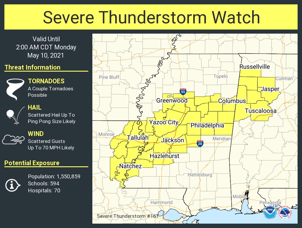
A Severe Thunderstorm Watch has been issued for Franklin County in North Alabama, and for Fayette, Lamar, Marion, Pickens, Tuscaloosa, Walker, and Winston counties in Central Alabama until 2 am CDT Monday morning.
The NWS Storm Prediction Center has issued a
* Severe Thunderstorm Watch for portions of
Northwest Alabama
Northeast Louisiana
Central Mississippi
* Effective this Sunday night and Monday morning from 730 PM
until 200 AM CDT.
* Primary threats include…
Scattered damaging wind gusts to 70 mph likely
Scattered large hail events to 1.5 inches in diameter likely
A tornado or two possible
SUMMARY… A fast-moving cluster of storms over northern Mississippi
will track into northwest Alabama, while other strong storms develop
across central Mississippi. All of this activity will pose a risk
of locally damaging wind gusts and hail through the early overnight
hours.
PRECAUTIONARY/PREPAREDNESS ACTIONS…
REMEMBER… A Severe Thunderstorm Watch means conditions are
favorable for severe thunderstorms in and close to the watch area.
Persons in these areas should be on the lookout for threatening
weather conditions and listen for later statements and possible
warnings. Severe thunderstorms can and occasionally do produce
tornadoes.
Category: Alabama's Weather, ALL POSTS, Severe Weather
About the Author (Author Profile)
Scott Martin is an operational meteorologist, professional graphic artist, musician, husband, and father. Not only is Scott a member of the National Weather Association, but he is also the Central Alabama Chapter of the NWA president. Scott is also the co-founder of Racecast Weather, which provides forecasts for many racing series across the USA. He also supplies forecasts for the BassMaster Elite Series events including the BassMaster Classic.Subscribe
If you enjoyed this article, subscribe to receive more just like it.


