Midday Nowcast: Warming Up with Sunshine in Full Supply
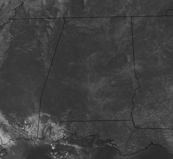
The upper ridge is intensifying across the Deep South, meaning continued dry weather with rising temperatures through the weekend. Today is featuring a mostly sunny sky with highs in the upper 80s, and it remains breezy with persistent easterly winds of 10-20 mph. For the weekend, both Saturday and Sunday will feature ample sunshine with highs in the upper 80s to low 90s, and perhaps some mid-90s.
CLOSE TO RECORD HEAT NEXT WEEK: The ridge holds in place across the Deep South, causing afternoon highs to climb into the mid-90s for many locations, which will be very close to records for this time of year. We will be looking for heat relief in the form of showers and storms, but with sinking air due to ridge and limited moisture levels, these will not materialize over Alabama. It looks like it may be sometime Memorial Day Weekend (May 29th-May 31st) before any meaningful rainfall returns to Alabama, if then. This looks to be a nearly two week span of no measurable rain for much of Alabama.
DOUBLE TROUBLE IN THE TROPICS: Though hurricane season officially begins, June 1st, we are already seeing two areas of concern.
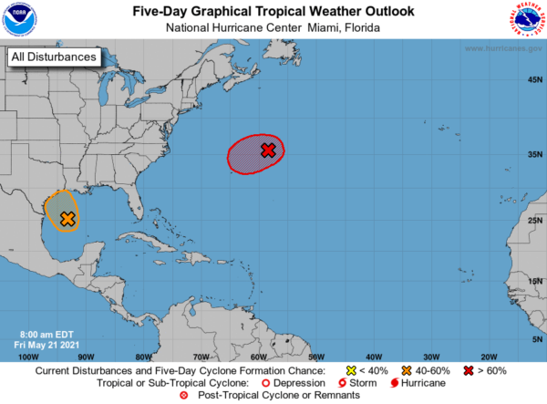
1. Showers and thunderstorms associated with a non-tropical low pressure area centered about 450 miles east-northeast of Bermuda have become better organized during the past several hours. The low has not yet acquired subtropical storm characteristics. However, if current trends continue advisories could be initiated on the system later today or tonight as it moves westward to west-southwestward to the northeast of Bermuda. Subsequently, the low is forecast to move northeastward into a more hostile environment by Saturday night or Sunday. Formation chance through 48 hours…high…90 percent.
2. Recent satellite imagery suggests that a low-level circulation is forming associated with the mid- to upper-level disturbance over the western Gulf of Mexico. However, shower and thunderstorm activity remains disorganized. Environmental conditions are expected to be marginally conducive for development, and a short-lived tropical depression or storm could form before the disturbance moves inland over the northwestern Gulf coast tonight. Regardless of development, the system could produce heavy rainfall over portions of southeastern Texas and southwestern Louisiana during the next few days. Formation chance through 48 hours…medium…40 percent.
If these two storms develop, they would be Ana and Bill.
BEACH FORECAST CENTER: Get the latest weather and rip current forecasts for the beaches from Fort Morgan to Panama City on our Beach Forecast Center page. There, you can select the forecast of the region that you are interested in visiting.
WORLD TEMPERATURE EXTREMES: Over the last 24 hours, the highest observation outside the U.S. was 117.5F at Jahra, Kuwait. The lowest observation was -98.9F at Vostok, Antarctica.
CONTIGUOUS TEMPERATURE EXTREMES: Over the last 24 hours, the highest observation was 105F at Rio Grande Village, TX. The lowest observation was 21F near Crater Lake, OR.
WEATHER ON THIS DATE IN 1860: A swarm of tornadoes occurred in the Ohio Valley. Tornadoes struck the cities of Louisville, KY, Cincinnati, OH, Chillicothe, OH, and Marietta, OH, causing a million dollars damage.
Category: Alabama's Weather, ALL POSTS
About the Author (Author Profile)
Macon, Georgia Television Chief Meteorologist, Birmingham native, and long time Contributor on AlabamaWX. Stormchaser. I did not choose Weather, it chose Me. College Football Fanatic. @Ryan_StinnetSubscribe
If you enjoyed this article, subscribe to receive more just like it.


