Midday Nowcast: Heavy Rain and a Flash Flood Watch
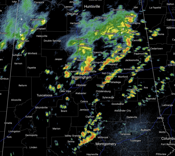
Widespread areas of very heavy rainfall continue to fall across much of North and Central Alabama as we roll into the afternoon hours. In fact, the NWS has issued a Flash Flood Watch for much of the area until 10PM tonight.
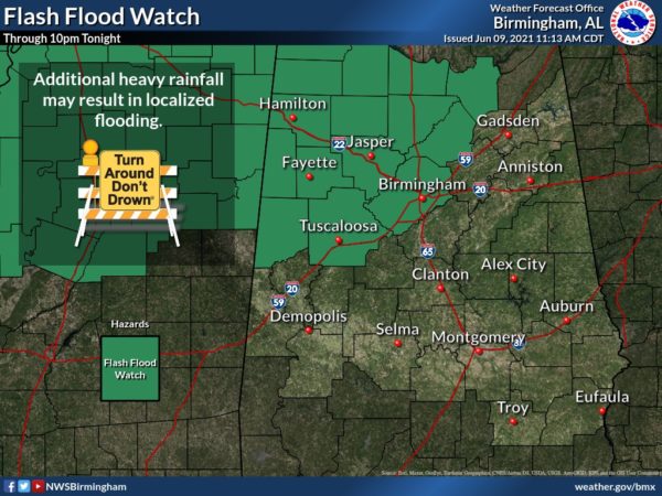
This includes Birmingham, Tuscaloosa, Jasper, and Cullman. Showers and storms are producing lots of lightning and torrential rainfall, and could result in areas of flash flooding, due the the high moisture content in the air.
REST OF THE WEEK: Not much change in the forecast for the rest of the week, as very muggy conditions persist. Each day we will see more clouds than sun, with temperatures heading into the upper 80s to lower 90s for most of locations. We will be watching the radar as showers and storms develop, and will be completely random in placement. Many locations will get wet during the afternoon and evening hours, while many others stay dry. Where the rain falls, it could be very heavy with areas of flash flooding, and rainfall totals will again vary greatly across the area, with some spots staying dry, and others possible getting 2-3 inches. The rain/storms gradually decrease in coverage overnight, but still lingering areas of rain will persist.
IN THE TROPICS: The Atlantic basin is quiet this morning, but a broad trough of low pressure is expected to develop over the southwestern Caribbean Sea during the next day or two. Significant development of this system appears unlikely as it drifts west-northwestward or northwestward toward Central America. Regardless of development, this system could produce heavy rainfall across northern Colombia and portions of Central America from Honduras southward later this week and into the weekend. Formation chance through 5 days…low…10 percent.
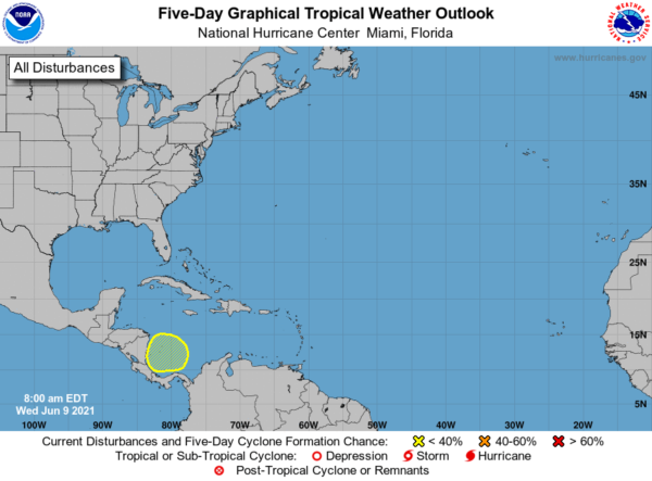
And, toward the latter half of next week, global models suggest a tropical low will form over the western Gulf of Mexico; just something to watch for now as it is way too early to be specific.
BEACH FORECAST CENTER: Get the latest weather and rip current forecasts for the beaches from Fort Morgan to Panama City on our Beach Forecast Center page. There, you can select the forecast of the region that you are interested in visiting.
WORLD TEMPERATURE EXTREMES: Over the last 24 hours, the highest observation outside the U.S. was 118.4F at Yenbo, Saudi Arabia. The lowest observation was -102.1F at Nico, Antarctica.
CONTIGUOUS TEMPERATURE EXTREMES: Over the last 24 hours, the highest observation was 115F at Rio Grande Village, TX. The lowest observation was 24F at Old Station, CA.
WEATHER ON THIS DATE IN 1987: Lightning struck Tire Mountain near Denver CO, destroying two million tires out of a huge pile of six million tires. Thunderstorms spawned three tornadoes around Denver, and a man was killed at Conifer CO when strong thunderstorm winds lifted up a porch and dropped it on him. A thunderstorm near Compton MD produced two inch hail, and high winds which destroyed twenty barns and ten houses injuring five persons.
Category: Alabama's Weather, ALL POSTS
About the Author (Author Profile)
Macon, Georgia Television Chief Meteorologist, Birmingham native, and long time Contributor on AlabamaWX. Stormchaser. I did not choose Weather, it chose Me. College Football Fanatic. @Ryan_StinnetSubscribe
If you enjoyed this article, subscribe to receive more just like it.


