

Sunday Weather Xtreme Video: One More Day of Storms, Then Drier Air Ahead, Still Watching for Late Week Gulf Tropical Development
June has started off on a wet note across Central Alabama, especially for areas west of I-65, but that will be changing in coming days thanks to a trough over the eastern United States that will begin to exert its will on our weather. It could also open the door for a little tropical trouble by mid to late week in the Gulf of Mexico and for the northern Gulf Coast. Let’s dig into the details.
SATURDAY HIGHS: Yesterday was a warm one, with high temperatures near 90F. Highs across Central Alabama included 90F at Tuscaloosa, and 91F at Birmingham, and Anniston. It was 92F at Montgomery and 93F at Troy. There were a few reports of wind damage in Morgan and Lauderdale Counties, as well as trees reported down in Greene County. But overall, the impact was minimal and the storms move south into the Mobile area during the evening. More storms will appear today with the heating of the day, aided by an upper-level trough over Alabama. Highs will once again be near 90F. The storms will die out quickly after sunset this evening.
CHANGES AHEAD: By tomorrow, the energy will be moving through the Great Lakes and Appalachians, sharpening the trough, and allowing a frontal boundary to make its way south into Alabama. The timing of the front should be such that Monday’s storm development is mainly over South Alabama. Again, the timing will be everything. The front should be most of the way through Central Alabama by Tuesday morning. And drier air will be following it.
LOWER DEWPOINTS AHEAD: Our current dewpoints in the 70s will be replaced by drier ones in the lower 60s for Tuesday, Wednesday, and Thursday. The drier air will mean on rain chances will be reduced to zero for all three days. Highs will be in near 90F on Tuesday, with lower and middle 80s on Wednesday, and upper 80s on Thursday. The low will be the best part. Morning readings on Wednesday will be in the lower and middle 60s.
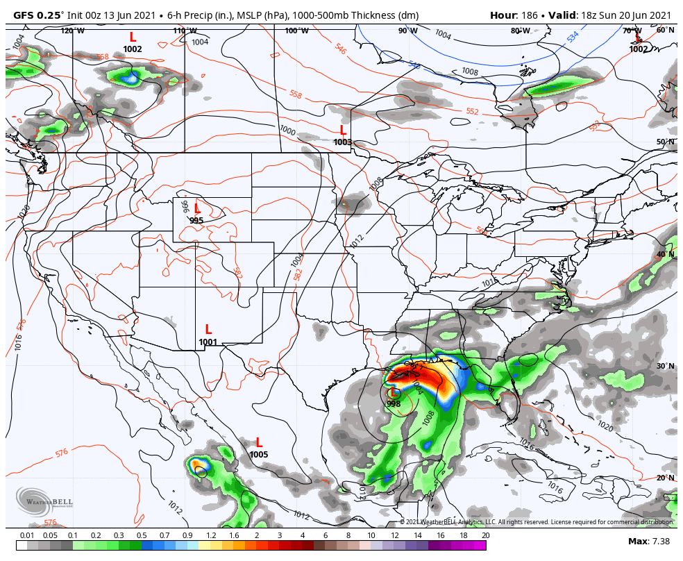
GFS Output for Next Sunday Showing a Tropical Storm approaching the Louisiana Coast.
TROPICAL POSSIBILITIES: An area of disturbed weather over the Bay of Campeche and southwestern Gulf of Mexico is drifting erratically and no development is expected in the short term. But by midweek, it appears that a low-pressure center may form over the southwestern Gulf and move northeastward. There is about a forty percent chance that a tropical depression or tropical storm could form by Wednesday. This system could bring heavy rain and tropical storm-force winds to the North Central Gulf of Mexico between Louisiana and Northwest Florida by Saturday or Sunday.
POTENTIAL IMPACTS FOR ALABAMA: A landfall on the Louisiana coast on Sunday could create a heavy rain event far in advance over parts of North and Central Alabama. Winds may become gusty across the area by Friday and Saturday ahead of the system. Heavy rain and winds of 30-40 mph could overspread South Alabama, Northwest Florida, and into southern Georgia by Sunday and Monday. This forecast is no certainty for sure, but there is a definite possibility that some version of this story will come true. We will be watching.
VOODOO TERRITORY: Out at the end of the period, around Monday the 28th, deep low pressure will be set up across the Great Lakes. This would position another front across Alabama and the Deep South, producing chances for showers and storms.
BEACHCAST: Fairly typical summertime weather in the week ahead along the beautiful beaches of Alabama and Northwest Florida. Just heat, humidity, scattered showers, and storms each day except Thursday, when high pressure should squelch any storms. After that, all eyes will be on the Gulf to see if it can spin up a tropical storm, which could bring wind and rain by the weekend.
Click here to see the Beach Forecast Center page.
DANCING WITH THE STATS: It was 110F at Tucson on Saturday, which broke the previous record for the date by 1 degree. More record heat is expected across Arizona and much of the Desert Southwest as a powerful high-pressure system takes hold across the region. Highs over the next seven days at Phoenix will range between 114 and 118. Several records could fall.
SIDEWALK: Birmingham’s world-class film festival returns to downtown venues this August. It is time to get your passes before prices increase on Tuesday. In any case, you can get 15% off your passes and tickets by using the discount code ALWX15 on checkout. Go to sidewalkfest.com for details!
WEATHERBRAINS: This week, the panel will entertain Mike Bates, who grew up loving The Weather Channel. When he realized the famed WeatherStar 4000 unit no longer existed, he decided to recreate it himself. We will talk to him Monday night on the show. Check out the show at www.WeatherBrains.com. You can also subscribe on iTunes. You can watch the show live at live.bigbrainsmedia.com or on James’ YouTube Channel You will be able to see the show on the James Spann 24×7 weather channel on cable or directly over the air on the dot 2 feed.
ON THIS DATE IN 2002: One of the most familiar and trusted faces on The Weather Channel was that of veteran hurricane forecaster John Raymond Hope. Hope died on this date of complications from heart surgery. He was 83 years old. Hope started with The Weather Channel as their tropical expert when the network debuted in 1982. Hope joined the National Hurricane Center in 1968 and quickly became a senior hurricane specialist. Known as “the man America watches when there is a hurricane,” Hope was a familiar and reassuring face to millions of Americans in coastal areas. Follow my weather history tweets on Twitter. I am @wxhistorian at Twitter.com.
Category: Alabama's Weather, ALL POSTS
About the Author (Author Profile)
Bill Murray is the President of The Weather Factory. He is the site's official weather historian and a weekend forecaster. He also anchors the site's severe weather coverage. Bill Murray is the proud holder of National Weather Association Digital Seal #0001 @wxhistorianSubscribe
If you enjoyed this article, subscribe to receive more just like it.


