PTC-3 Still Lacks Organization as of 10:00 pm
THE POTENTIAL TROPICAL CYCLONE REMAINS POORLY ORGANIZED AS IT MOVES OVER THE SOUTHWESTERN GULF OF MEXICO; EXPECTED TO BRING HEAVY RAINFALL AND FLOODING TO THE NORTHERN GULF COAST.
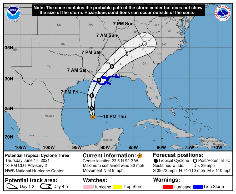
SUMMARY OF 1000 PM CDT…0300 UTC…INFORMATION
LOCATION…23.5N 92.2W
ABOUT 435 MI…695 KM S OF MORGAN CITY LOUISIANA
MAXIMUM SUSTAINED WINDS…30 MPH…45 KM/H
PRESENT MOVEMENT…N OR 360 DEGREES AT 9 MPH…15 KM/H
MINIMUM CENTRAL PRESSURE…1007 MB…29.74 INCHES
SUMMARY OF WATCHES AND WARNINGS IN EFFECT
A Tropical Storm Warning is in effect for…
* Intracoastal City Louisiana to the Alabama/Florida border
* Lake Pontchartrain, Lake Maurepas, and Metropolitan New Orleans
A Tropical Storm Warning means that tropical storm conditions are expected somewhere within the warning area within 36 hours. Interests elsewhere along the northern Gulf Coast should monitor the progress of this system.
FORECAST DISCUSSION
Satellite imagery and data from an Air Force Reserve Hurricane Hunter aircraft indicate that the low-pressure area over the southwestern Gulf of Mexico has changed little in organization during the past several hours, and the associated convection lies well to the east of the broad and poorly defined center. The initial intensity will be held at 25 kt based partially on ship reports from the northeastern and northern parts of the system.
Due to the poorly defined center, the initial motion is a highly uncertain 360/8. The system should move generally northward for the next 24-36 h to a position near the coast of Louisiana, followed by a motion toward the northeast across the southeastern United States as it moves through a weakness in the subtropical ridge caused by an upper-level trough over Texas, northern Mexico, and the adjacent Gulf of Mexico. The forecast track is basically an update of the previous forecast. It should be noted that the latest GFS run continues to forecast a re-formation of the center to the north sometime on Friday, and the forecast forward motion tries to account for this possibility.
The aforementioned upper-level trough is causing shear over the system, and present indications are that some shear will persist through landfall and hinder development. The intensity forecast calls for the low to become a tropical cyclone in about 12 h, followed by some modest strengthening to tropical storm strength at 24-36 h. This would be followed by weakening over land, with the system dissipating over the southeastern United States between 72-96 h. There is a chance that, due to the interaction with the upper-level trough, the system may take on subtropical cyclone characteristics instead of tropical cyclone characteristics. The new intensity forecast is similar to the previous forecast, and it lies at the upper edge of the intensity guidance envelope.
Given the current and anticipated structure of this system, users should not focus on the exact track of the center, as rainfall and wind hazards are likely to extend well east of the center and arrive well in advance of landfall.
KEY MESSAGES
1. The system is expected to produce heavy rainfall, considerable flash, urban and small stream flooding beginning Friday and continuing through the weekend along the Central Gulf Coast, spreading northeastward into the Southern Appalachians.
2. Tropical storm conditions are expected to begin Friday in areas near and well to the east of the center along portions of the central Gulf Coast from Intracoastal City, Louisiana, to the Alabama/Florida border, including New Orleans.
Category: Alabama's Weather, ALL POSTS, Severe Weather, Tropical
About the Author (Author Profile)
Scott Martin is an operational meteorologist, professional graphic artist, musician, husband, and father. Not only is Scott a member of the National Weather Association, but he is also the Central Alabama Chapter of the NWA president. Scott is also the co-founder of Racecast Weather, which provides forecasts for many racing series across the USA. He also supplies forecasts for the BassMaster Elite Series events including the BassMaster Classic.Subscribe
If you enjoyed this article, subscribe to receive more just like it.


