Latest on Claudette, Plus an Update on Central Alabama’s Weather at 8 pm
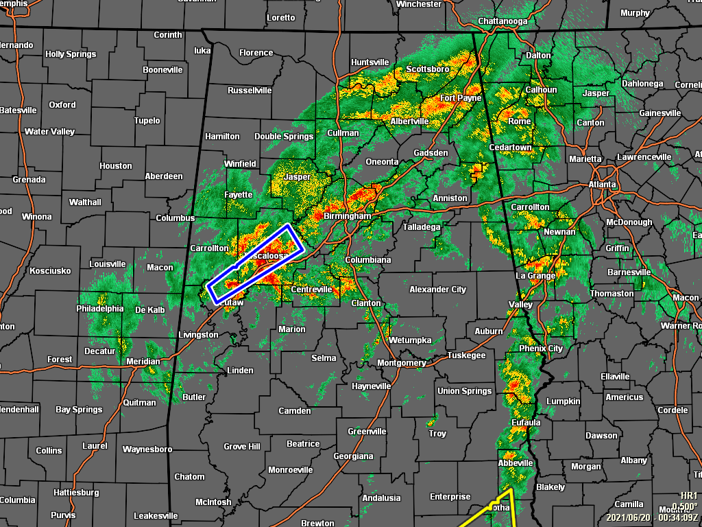
Much of the southern portions of Central Alabama have dried out from the torrential rains that fell during the morning and afternoon hours, while much of the activity continues along and north of the I-20 corridor. At this point, a Flash Flood Warning continues for portions of Greene and Tuscaloosa counties until 9:45 pm tonight as there will continue to be a threat as another 1 to 3 inches of rain may fall over the next couple of hours.
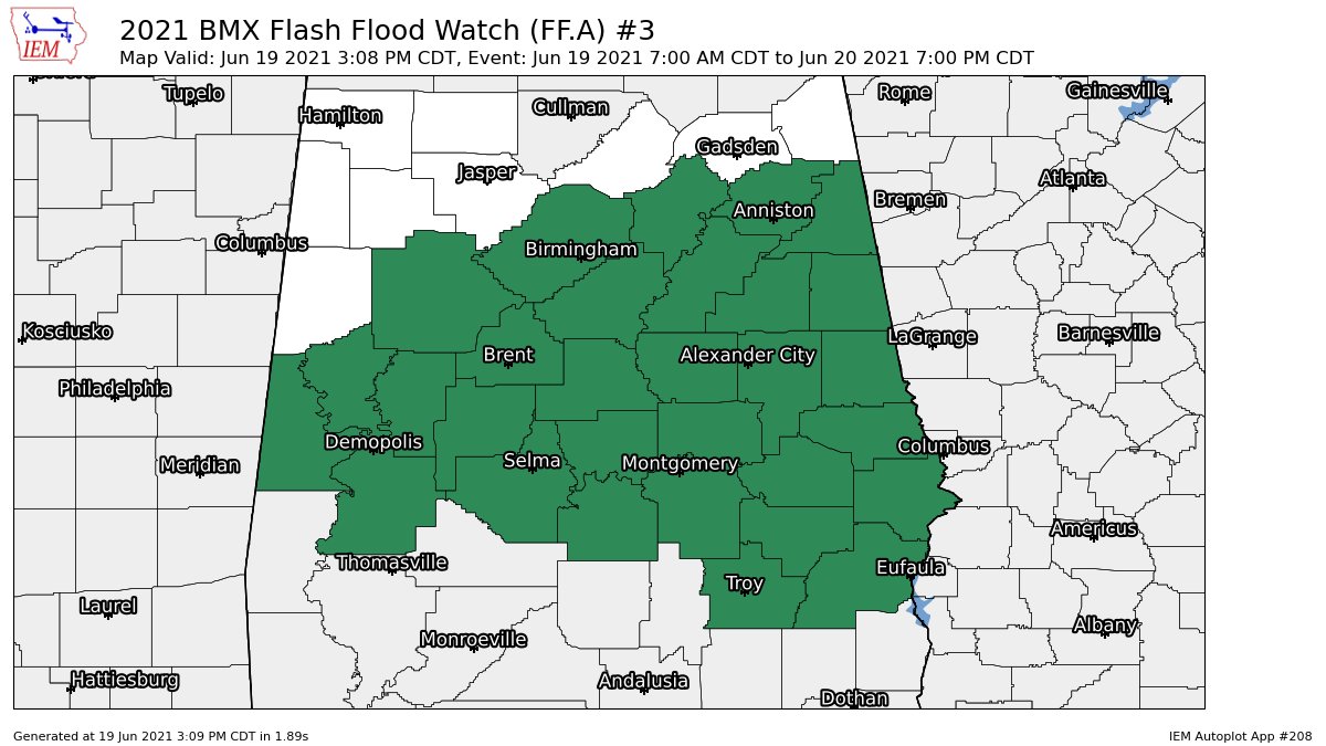
A Flash Flood Watch continues for Autauga, Bibb, Chilton, Coosa, Elmore, Jefferson, Lowndes, Montgomery, Shelby, St. Clair, Talladega, Calhoun, Chambers, Clay, Cleburne, Lee, Macon, Randolph, Russell, Tallapoosa, Barbour, Bullock, Pike, and Tuscaloosa counties until 7:00 pm Sunday evening.
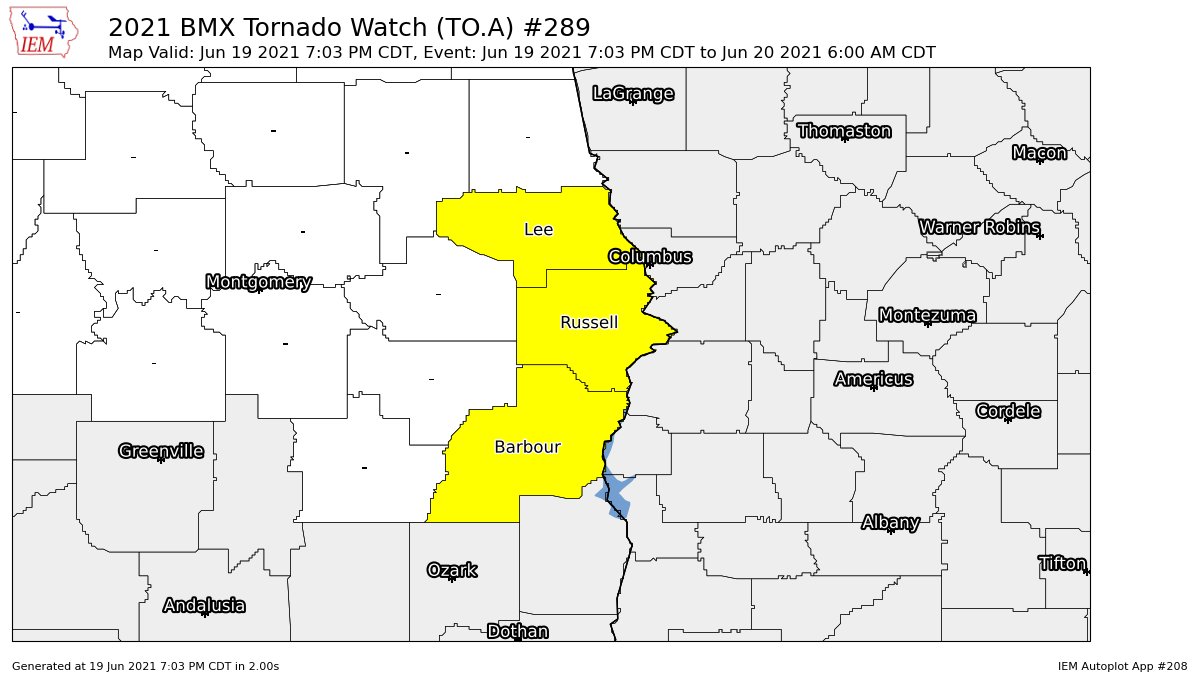
A Tornado Watch continues for Barbour, Lee, and Russell counties until 6:00 am Sunday morning.
Tropical showers and storms will continue across portions of the area through the rest of the night and through the overnight hours, but the good news is that it will continue to lose strength and rainfall will be in the process of diminishing somewhat in coverage as it all moves eastward. By sunrise on Sunday morning, the western half of Central Alabama looks to be rain-free while the back half of Claudette will be in the process of exiting the state. Believe it or not, all of Central Alabama looks to be dry by the midday hour and sunshine will make an appearance.
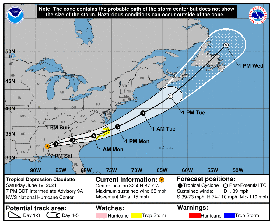
The latest update (7 pm) on Claudette has the center located around 75 miles west of Montgomery and moving to the northeast at 15 mph. Maximum sustained winds are at 35 mph with the pressure up to 1005 mb. While all tropical storm warnings have been discontinued along the Gulf Coast, the latest forecast has Claudette reemerging over the Atlantic Ocean off of the coast of North Carolina and restrengthening back to tropical storm strength. A Tropical Storm Watch has already been issued for the North Carolina coastline as Claudette passes over during the pre-dawn hours on Monday morning. After that, Claudette will turn more to the northeast and accelerate away from the US until becoming post-tropical and moving onshore over the extreme portions of northeastern Canada. Here are the latest key messages on Claudette:
1. Claudette is expected to produce heavy rainfall and flash flooding across portions of the Florida Panhandle, eastern Alabama, and Georgia through tonight, and into the Carolinas on Sunday. Considerable flash, urban, and small stream flooding impacts are expected across these areas.
2. Tropical storm conditions are possible along portions of the North Carolina coast Sunday night and Monday, where a Tropical Storm Watch is in effect.
Category: Alabama's Weather, ALL POSTS, Severe Weather, Tropical
About the Author (Author Profile)
Scott Martin is an operational meteorologist, professional graphic artist, musician, husband, and father. Not only is Scott a member of the National Weather Association, but he is also the Central Alabama Chapter of the NWA president. Scott is also the co-founder of Racecast Weather, which provides forecasts for many racing series across the USA. He also supplies forecasts for the BassMaster Elite Series events including the BassMaster Classic.Subscribe
If you enjoyed this article, subscribe to receive more just like it.


