Flash Flood Warning for Jefferson County Extended Until 2 a.m.
The Flash Flood Warning for Jefferson County has been extended until 2 a.m..
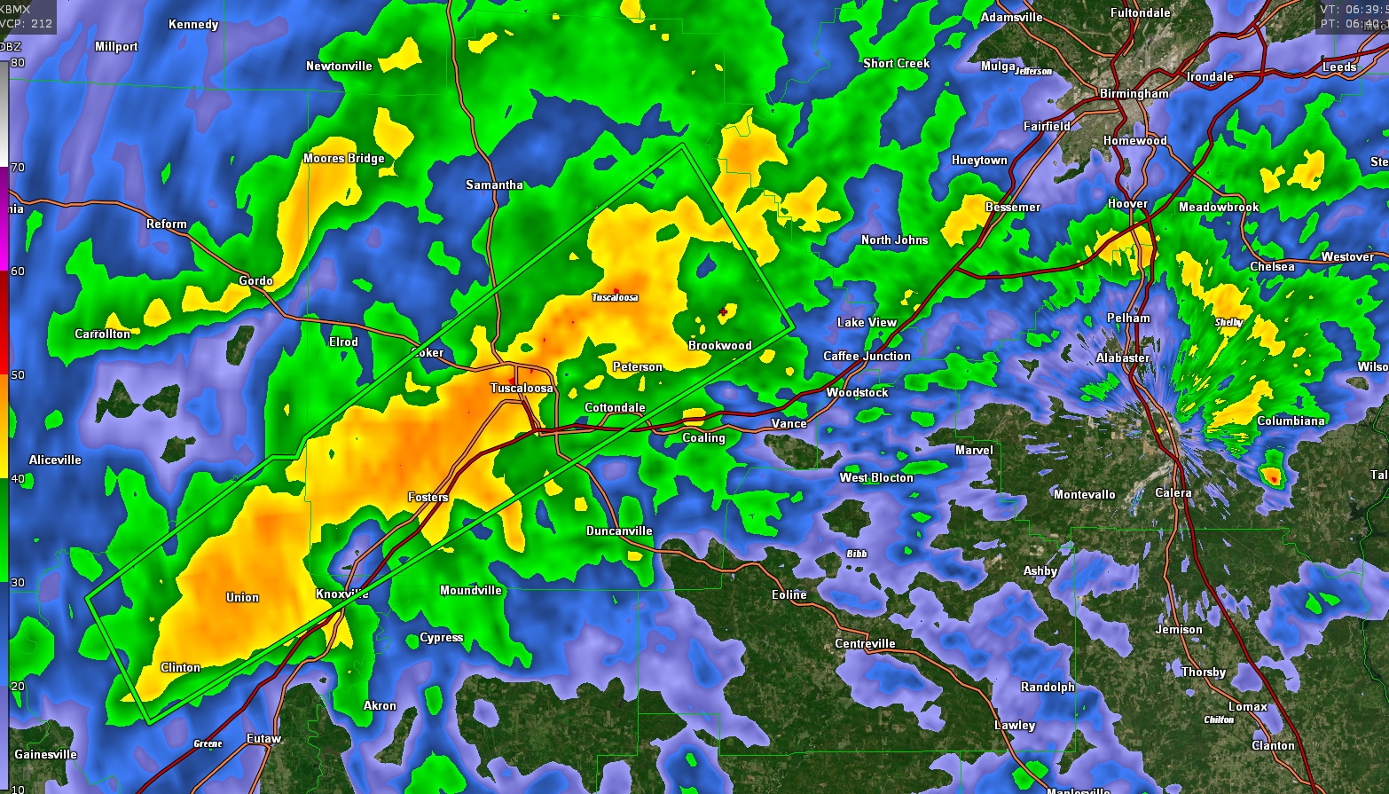
Life-threatening flooding is ongoing across the Birmingham Metro area with numerous water rescues underway.
WE still have several more hours of moderate rain to endure across the Birmingham area.
ORIGINAL POST
WEA Alerts are sounding across the Biringham area as the NWS has upgraded the Jefferson County Flash Flood Warning with a CONSIDERABLtag indicating LIFE THREATENING flash flooding.
Several roasd are flooded in Tarrant. Cars are stalled at 1t Avenue and 41st Street,
FLASH FLOOD STATEMENT
NATIONAL WEATHER SERVICE BIRMINGHAM AL
949 PM CDT SAT JUN 19 2021
ALC073-200515-
/O.CON.KBMX.FF.W.0031.000000T0000Z-210620T0515Z/
/00000.0.ER.000000T0000Z.000000T0000Z.000000T0000Z.OO/
JEFFERSON AL-
949 PM CDT SAT JUN 19 2021
…FLASH FLOOD WARNING REMAINS IN EFFECT UNTIL 1215 AM CDT SUNDAY
FOR JEFFERSON COUNTY…
AT 949 PM CDT, DOPPLER RADAR INDICATED THUNDERSTORMS PRODUCING HEAVY
RAIN ACROSS THE WARNED AREA. BETWEEN 2 AND 4 INCHES OF RAIN HAVE
FALLEN. ADDITIONAL RAINFALL AMOUNTS OF 1 TO 3 INCHES ARE POSSIBLE IN
THE WARNED AREA. FLASH FLOODING IS ALREADY OCCURRING.
HAZARD…LIFE THREATENING FLASH FLOODING. THUNDERSTORMS PRODUCING
FLASH FLOODING.
SOURCE…RADAR.
IMPACT…LIFE THREATENING FLASH FLOODING OF CREEKS AND STREAMS,
URBAN AREAS, HIGHWAYS, STREETS AND UNDERPASSES.
SOME LOCATIONS THAT WILL EXPERIENCE FLASH FLOODING INCLUDE…
BIRMINGHAM, HOOVER, VESTAVIA HILLS, BESSEMER, HOMEWOOD, PELHAM,
MOUNTAIN BROOK, TRUSSVILLE, HELENA, HUEYTOWN, GARDENDALE,
IRONDALE, LEEDS, MOODY, FAIRFIELD, FULTONDALE, CENTER POINT,
PLEASANT GROVE, CLAY AND PINSON.
PRECAUTIONARY/PREPAREDNESS ACTIONS…
TURN AROUND, DON’T DROWN WHEN ENCOUNTERING FLOODED ROADS. MOST FLOOD
DEATHS OCCUR IN VEHICLES.
&&
LAT…LON 3347 8667 3342 8672 3342 8675 3337 8678
3336 8683 3333 8683 3333 8688 3325 8698
3325 8707 3328 8707 3331 8716 3340 8725
3359 8708 3382 8673 3377 8665 3377 8654
3366 8653 3347 8660
FLASH FLOOD…RADAR INDICATED
FLASH FLOOD DAMAGE THREAT…CONSIDERABLE
ORIGINAL POST
Heavy rain continues in the Birmingham Metro, and even more, intense rainfall is pushing toward the area.
Serious flooding is occurring in Tuscaloosa. please don’t drive if you don’t have to.
BULLETIN – EAS ACTIVATION REQUESTED
Flash Flood Warning
National Weather Service Birmingham AL
906 PM CDT Sat Jun 19 2021
The National Weather Service in Birmingham has issued a
* Flash Flood Warning for…
Jefferson County in central Alabama…
* Until 1215 AM CDT.
* At 906 PM CDT, Doppler radar indicated thunderstorms producing
heavy rain across the warned area. Between 2 and 3 inches of rain
have fallen. Additional rainfall amounts of 1 to 3 inches are
possible in the warned area. Flash flooding is ongoing or expected
to begin shortly.
HAZARD…Flash flooding caused by thunderstorms.
SOURCE…Radar.
IMPACT…Flash flooding of small creeks and streams, urban
areas, highways, streets and underpasses as well as
other poor drainage and low-lying areas.
* Some locations that will experience flash flooding include…
Birmingham, Hoover, Vestavia Hills, Bessemer, Homewood, Pelham,
Mountain Brook, Trussville, Helena, Hueytown, Gardendale,
Irondale, Leeds, Moody, Fairfield, Fultondale, Center Point,
Pleasant Grove, Clay and Pinson.
PRECAUTIONARY/PREPAREDNESS ACTIONS…
Turn around, don’t drown when encountering flooded roads. Most flood
deaths occur in vehicles.
Category: Alabama's Weather, ALL POSTS, Severe Weather, Tropical
About the Author (Author Profile)
Bill Murray is the President of The Weather Factory. He is the site's official weather historian and a weekend forecaster. He also anchors the site's severe weather coverage. Bill Murray is the proud holder of National Weather Association Digital Seal #0001 @wxhistorianSubscribe
If you enjoyed this article, subscribe to receive more just like it.


