Weather Xtreme for Sunday, June 20, 2021: Happy Father’s Day After A Night of Heavy Rain and Flooding
BYE CLAUDETTE: Tropical Storm Claudette finally got a name early Saturday morning in the last few hours before landfall in southern Louisiana. The storm finally got a closed circulation and could be designated as a tropical cyclone. The storm caused heavy rain, tropical storm force winds, a storm surge of 2-5 feet, tornadoes, and south seas and rip currents.
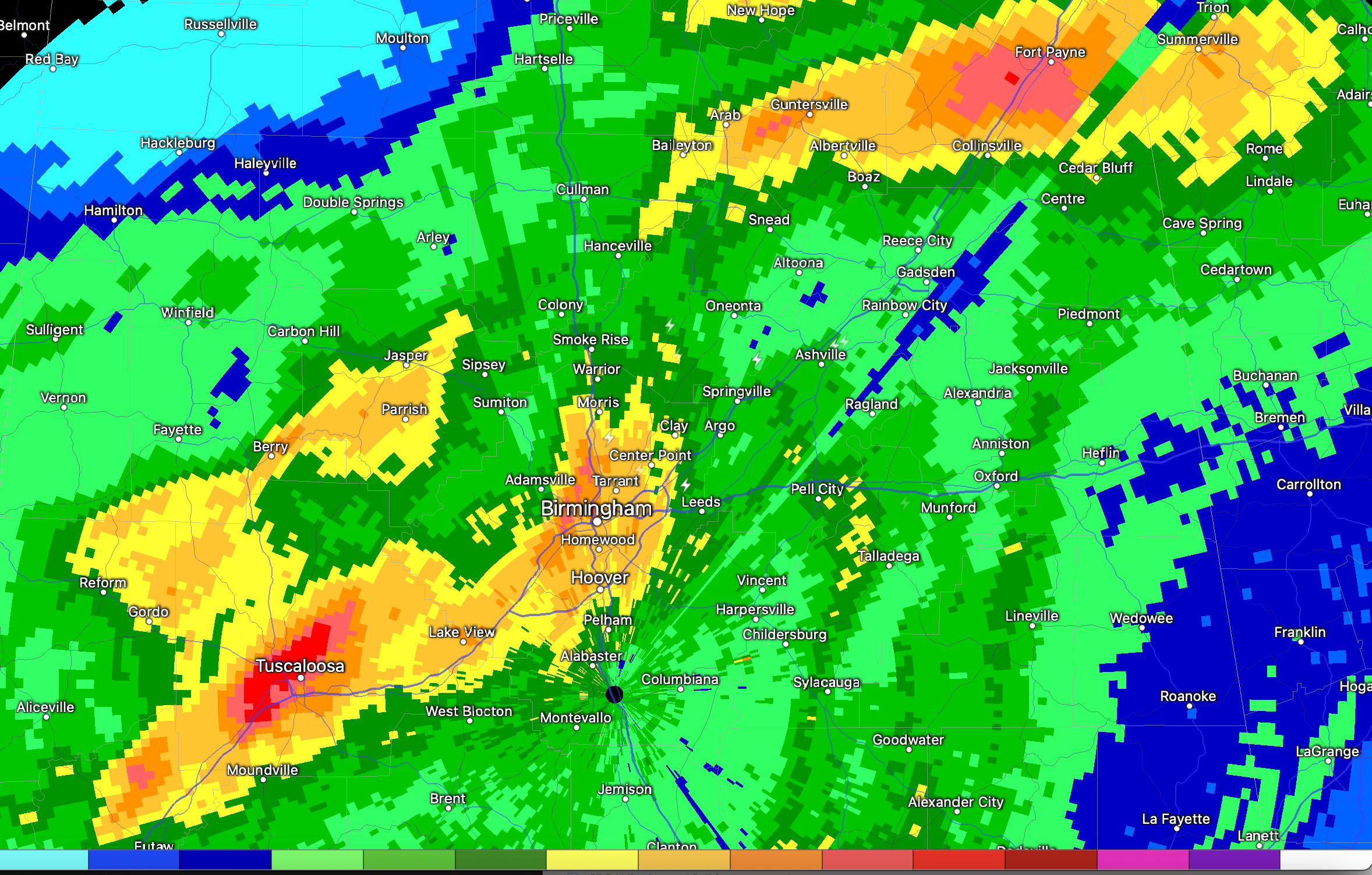
CENTRAL ALABAMA FLOODING: The above image shows accumulated rainfall over North Central Alabama for Saturday, with totals surpassing 4-7 inches in the Tuscaloosa and Birmingham area. By late afternoon, an area of low-level convergence and upper-level divergence caused an explosion of thunderstorms over West Alabama. Tuscaloosa and Greene Counties were the bullseye for several hours of heavy rain that dumped 7-8 inches of the Tuscaloosa/Northport area. Flooding was terrible in those communities, with numerous roads impassable and even a mudslide in downtown T-Town. The flooding rains reached the Birmingham area by mid-evening, and flash flood warnings were necessary.
IMPROVING CONDITIONS: A few leftover showers on the backside of the circulation of the tropical depression are affecting Alabama early this morning. The center of the depression is near LaGrange, Georgia this morning, just across the border from Lanett, Alabama. Top winds are down to 30 mph. The system will continue progressing across Georgia today and will be into South Carolina by evening. Skies should slowly clear from the west today, with areas west of I-65 sunny by afternoon and by over eastern sections by mid to late afternoon. A healthy cumulus field will pop up in the sunshine on the backside of the system. Temperatures today will be in the middle 80s generally across Alabama. Lows tonight will be in the muggy lower 70s with a southwest wind gusting at times to 15-20 mph.
ANOTHER FRONT: Another upper-level trough will begin amplifying to our northwest by Monday and by early Tuesday, it will propel a fairly decent cold front for July into Alabama. Monday will feature a soupy, warm, moist airmass across Alabama and with plenty of instability and an approaching front, showers and thunderstorms will be fairly numerous. Afternoon readings will be in the muggy middle 80s. Chances for rain and storms will stay with us through the overnight hours Monday night as the front draws closer. The front should push through Northwest Alabama Tuesday morning. The main push of storms on Tuesday will be south of I-59. Some of those could be strong for sure. The front will settle into South Alabama Tuesday night. A wave rippling along the front could trigger a northward advance of showers and storms on Wednesday. Rinse and repeat for Thursday when the frontal boundary could light up again with showers and storms. Highs all week will be in the middle 80s with lows generally in the upper 60s to near 70F, except Wednesday morning, when a few lower and middle 60s will be observed.
WEEKEND OUTLOOK: It looks like a couple of other fronts will plague the area Friday and Sunday, keeping us in rain chances all three days. Highs will be in the middle 80s. Lows will be near 70F.
BEACHCAST: Showers and storms will be an integral part of the forecast along the beaches of Alabama and Northwest Florida. Highs will be in the middle 80s. Lows in the middle 70s. Water temperatures are near 80F. There will be a high rip current risk through Tuesday night.
Click here to see the Beach Forecast Center page.
DANCING WITH THE STATS: Claudette is the 8th Atlantic tropical cyclone to bear the unusual and beautiful name. It is left over from the 1979 list of named storms that was the first to contain male names. 1979’s Claudette was a memorable storm because it dumped 42 inches of rain at Alvin, Texas in 24 hours, a record that still stands for the lower 48. The 1985 iteration was a long-lived hurricane that remained out over the open Atlantic. The 1991 version was a low-end Category 4 that remained over water its entire life. 1997 Claudette was a short-lived storm that formed after a frontal system moved off the U.S. Atlantic coast. Hurricane Claudette in 2003 hit Mexico and then South Texas. The Claudette of 2009 formed over the Gulf of Mexico and made landfall on the Florida Panhandle. The 2015 edition was a short-lived tropical storm that formed off the U.S. East Coast and dissipated over the open Atlantic without making landfall. 9 C names have been retired from the list over the years. Claudette’s place on the 2027 list is safe.
ADVERTISE WITH US: Deliver your message to a highly engaged audience by advertising on the AlabamaWX.com website. The site enjoyed 25 MILLION page views in the past 12 months. Don’t miss out! We can customize a creative, flexible, and affordable package that will suit your organization’s needs. Contact me, Bill Murray, at (205) 687-0782 and let’s talk.
WEATHERBRAINS: This week’s show is in the can already with James’ imminent vacation. We visited with Storm Chaser Aaron Rigsby on the show, which will be released tomorrow night on the normal channels. Check out the show at www.WeatherBrains.com. You can also subscribe on iTunes. You can watch the show live at live.bigbrainsmedia.com or on James’ YouTube Channel You will be able to see the show on the James Spann 24×7 weather channel on cable or directly over the air on the dot 2 feed.
ON THIS DATE IN 1957: A violent tornado tore through Fargo ND. 10 people were killed, 103 were injured. 1,300 homes were damaged or destroyed. The twister tore a 56 mile-long, 800 yards wide path through the city. The tornado caused $10 million in damage. As the tornado moved toward the city, warnings were broadcast on television and radio. Instead of taking cover, many residents ran outside to photograph and film the twister. Tornado researcher Ted Fujita was able to collect many of the home videos and photographs. Fujita was able to dissect the life cycle of the supercell storm and the tornado it produced. He coined names for the wall cloud, the collar cloud, and the tail cloud, terms that are at the center of the spotter lexicon today. The watershed study of the supercell showed that these formations were not random occurrences, but symptoms of processes that are ongoing in a severe thunderstorm and therefore important visual clues to what the storm is going to do. Follow my weather history tweets on Twitter. I am @wxhistorian at Twitter.com.
Category: Alabama's Weather, ALL POSTS, Severe Weather, Tropical
About the Author (Author Profile)
Bill Murray is the President of The Weather Factory. He is the site's official weather historian and a weekend forecaster. He also anchors the site's severe weather coverage. Bill Murray is the proud holder of National Weather Association Digital Seal #0001 @wxhistorianSubscribe
If you enjoyed this article, subscribe to receive more just like it.


