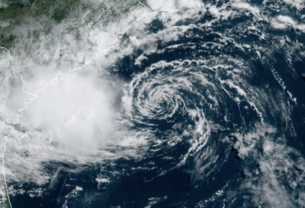
Midday Nowcast: Mainly Dry Today; Tropical Depression Four Develops
The final Monday of June is not too bad across Alabama; we are seeing more sun than clouds, but do note clouds are increasing from the southeast as tropical moisture streams inland associated with the tropical system off the Southeast Coast. It will remain mainly dry today, with only a few isolated storms this afternoon, but these will remain few and far between. Temperatures this afternoon will range from the upper 80s to lower 90s.
IN THE TROPICS: Tropical Depression Four has formed off the Southeast coast, and will likely be Danny before it makes landfall later this evening or tonight.
Latest update from the NHC: The center of Tropical Depression Four was located near latitude 31.9 North, longitude 78.3 West. The depression is moving toward the west-northwest near 16 mph and this general motion is expected to continue for the next couple of days. On the forecast track, the center of the tropical cyclone should make landfall along coast of South Carolina in the warning area later this evening.
Maximum sustained winds are near 35 mph with higher gusts. Some slight strengthening is expected today, and the depression is forecast to become a tropical storm before it makes landfall. Rapid weakening is forecast after landfall occurs.The estimated minimum central pressure is 1013 mb (29.92 inches).
Also, Invest-95L continues as a broad area of low pressure associated with a tropical wave is producing a small cluster of showers and thunderstorms over the central tropical Atlantic Ocean. Some slow development is possible through the end of the week while this system moves quickly westward to west-northwestward at about 20 mph, likely reaching the Lesser Antilles Wednesday night. Formation chance through 5 days…medium…40 percent.
INCREASING RAIN CHANCES: Tropical Depression Four (likely Danny) will move into the Georgia coast this evening, and the remnant low will move westward into North Alabama tomorrow. This will bring higher rain chances for tomorrow as scattered to numerous showers and storms will develop across the Alabama landscape, especially during the afternoon hours. Highs tomorrow will be in the 80s. For Wednesday and Thursday, higher moisture levels will linger across the state, meaning both days will feature scattered, mostly afternoon and evening showers and thunderstorms. These days will feature a mix of sun and clouds with highs in the upper 80s.
LONG HOLIDAY WEEKEND: A trough develops over the eastern half of the U.S., which looks to allow a surface front to drop into and stall across Alabama this weekend. Friday through Sunday will feature partly sunny conditions and highs in the 80s, we are forecasting higher rain chances with scattered and numerous showers and storms these three days. Of course, there are many outdoor events planned for the Fourth of July, and though we will have to deal with occasional showers and storms along the way, the weekend won’t be a total “wash out”. Rain amounts on these three days will likely be in the two inch range for many places.
BEACH FORECAST CENTER: Get the latest weather and rip current forecasts for the beaches from Fort Morgan to Panama City on our Beach Forecast Center page. There, you can select the forecast of the region that you are interested in visiting.
WORLD TEMPERATURE EXTREMES: Over the last 24 hours, the highest observation outside the U.S. was 126.5F at Jahra, Kuwait. The lowest observation was -108.0F at Vostok, Antarctica.
CONTIGUOUS TEMPERATURE EXTREMES: Over the last 24 hours, the highest observation was 122F at Death Valley, CA. The lowest observation was 29F at Peter Sinks, UT.
Category: Alabama's Weather, ALL POSTS, Tropical


