

Midday Nowcast: Mainly Sunny, Waiting on Scattered Afternoon Storms
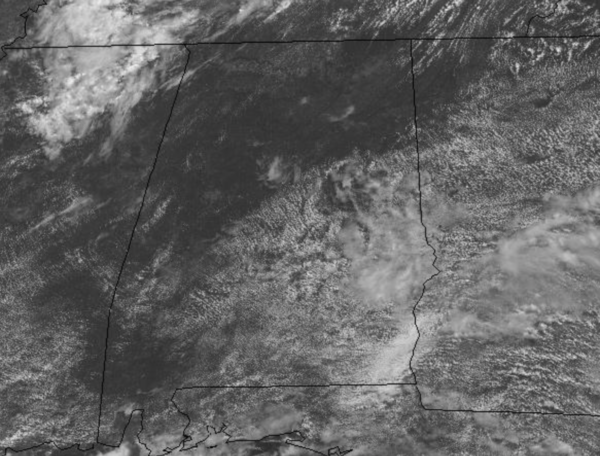
Today is muggy as tropical moisture remains in place across the state. We are seeing more sun than clouds through the morning hours, but heading into the afternoon, clouds are increasing and these will become those randomly scattered, showers and thunderstorms this afternoon and evening. Pretty routine for summertime in Alabama, before the storms get going, temperature are heading into the upper 80s and lower 90s across the state. For tomorrow, rinse and repeat today.
ACROSS THE USA: The historic heat wave continues in the Northwestern quadrant of the U.S. with record shattering temperatures across interior portions of the region. Meanwhile, sweltering heat also consumes a large part of the Northeast and Mid-Atlantic, including the Boston, New York and Philadelphia metro areas. Finally, severe thunderstorms with damaging winds will be common in the Northeast on Wednesday.
IN THE TROPICS: Elsa maybe coming sooner than later.
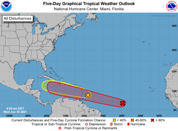
INVEST 97L: A broad area of low pressure, associated with a tropical wave, is located about midway between the west coast of Africa and the Windward Islands. This system is producing a large area of showers and thunderstorms that continues to show some signs of organization. Environmental conditions appear generally favorable for development, and a tropical depression is likely to form during the next few days while the system moves west-northwestward at about 20 mph. Interests in the Windward and Leeward Islands should closely monitor this system as it will likely be moving through that region on Friday. Formation chance through 5 days…high…80 percent. We will have to keep an eye on this system through the weekend, but it is too early to know if this system will ultimately reach the Gulf of Mexico, or turn northward before impacting the U.S. Nobody knows the ultimate destination or intensity now…once the system develops, and we get upper air dropsonde data from hurricane hunters, confidence in the forecast track will increase.
INVEST 95L: Disorganized showers and thunderstorms continue in association with a tropical wave located just east of the Lesser Antilles. Significant development of this system is unlikely while it moves quickly westward to west-northwestward at 20 to 25 mph, passing through the Lesser Antilles today and then across the eastern and central Caribbean Sea later this week. Regardless of development, this system could bring locally heavy rainfall to portions of the Lesser Antilles during the next day or two. Formation chance through 5 days…low…10 percent.
FRIDAY FRONT: A developing trough over the eastern half of the U.S. will allow a surface front to drop into Alabama. This front will be increasing our rain chances and Friday looks to be a rather wet day for the state. The will be cloudy with periods of rain and storms, with rain amounts over an inch in most locations. Due to the clouds and rain, high Friday will struggle to reach the 80s across North/Central Alabama.
BEACH FORECAST CENTER: Get the latest weather and rip current forecasts for the beaches from Fort Morgan to Panama City on our Beach Forecast Center page. There, you can select the forecast of the region that you are interested in visiting.
WORLD TEMPERATURE EXTREMES: Over the last 24 hours, the highest observation outside the U.S. was 124.2F at Jahra, Kuwait. The lowest observation was -101.6F at Ago-4, Antarctica.
CONTIGUOUS TEMPERATURE EXTREMES: Over the last 24 hours, the highest observation was 121F at Death Valley, CA. The lowest observation was 28F at Albany, WY.
WEATHER ON THIS DATE IN 1987: Hot weather prevailed in the Pacific Northwest, with readings above 100 degrees reported as far north as southern British Columbia. Yakima, WA, reported a record high of 100 degrees, while temperatures near the Washington coast hovered near 60 degrees all day.
Category: Alabama's Weather, ALL POSTS
About the Author (Author Profile)
Macon, Georgia Television Chief Meteorologist, Birmingham native, and long time Contributor on AlabamaWX. Stormchaser. I did not choose Weather, it chose Me. College Football Fanatic. @Ryan_StinnetSubscribe
If you enjoyed this article, subscribe to receive more just like it.


