Elsa Strengthens As It Transitions Into the Caribbean Sea
SUMMARY OF 200 PM AST…1800 UTC…INFORMATION
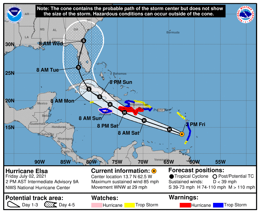
LOCATION…13.7N 62.5W
ABOUT 95 MI…155 KM WNW OF ST. VINCENT
ABOUT 580 MI…935 KM ESE OF SANTO DOMINGO, DOMINICAN REPUBLIC
MAXIMUM SUSTAINED WINDS…85 MPH…140 KM/H
PRESENT MOVEMENT…WNW OR 290 DEGREES AT 29 MPH…46 KM/H
MINIMUM CENTRAL PRESSURE…991 MB…29.26 INCHES
WATCHES AND WARNINGS
A Hurricane Warning is in effect for…
* Southern coast of the Dominican Republic from Punta Palenque to the border with Haiti
* Southern portion of Haiti from Port-au-Prince to the southern border with the Dominican Republic
A Tropical Storm Warning is in effect for…
* St. Vincent and the Grenadines
* St. Lucia
* Martinique
* Dominica
* The coast of Haiti north of Port-au-Prince
* South coast of the Dominican Republic east of Punta Palenque to Cabo Engano
* Jamaica
A Hurricane Watch is in effect for…
* Jamaica
A Tropical Storm Watch is in effect for…
* Grenada and its dependencies
* Saba and Sint Eustatius
* North coast of the Dominican Republic from Cabo Engano to Bahia de Manzanillo
* Cayman Brac and Little Cayman
Interests elsewhere in the Windward Islands, Leeward Islands, the Virgin Islands, Puerto Rico, the Dominican Republic, Cuba, and the Cayman Islands should monitor the progress of Elsa. Additional watches and warnings will likely be required later today.
DISCUSSION AND OUTLOOK
At 200 PM AST (1800 UTC), the center of Hurricane Elsa was located near latitude 13.7 North, longitude 62.5 West. Elsa is moving toward the west-northwest near 29 mph (46 km/h), and this motion is expected to continue during the next couple of days, with some decrease in forward speed expected Sunday night. On the forecast track, Elsa will move away from the Windward Islands during the next several hours, move across the eastern Caribbean Sea this afternoon and tonight, and move near the southern coast of Hispaniola late Saturday or Saturday night. By Sunday, Elsa is forecast to move near Jamaica and portions of eastern Cuba, and move near portions of central and western Cuba Sunday night and early Monday.
Reports from a NOAA Hurricane Hunter aircraft indicate that maximum sustained winds are now near 85 mph (140 km/h) with higher gusts. Little change in strength is forecast during the next 48 hours. Some decrease in winds is possible on Monday as Elsa interacts with Cuba.
Hurricane-force winds extend outward up to 25 miles (35 km) from the center, and tropical-storm-force winds extend outward up to 140 miles (220 km). The minimum central pressure estimated from the NOAA Hurricane Hunter data is 991 mb (29.26 inches).
HAZARDS AFFECTING LAND
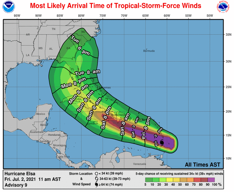
WIND: Tropical storm conditions are expected in the tropical storm warning area in the Windward Islands for the next few hours. Tropical storm conditions are expected in portions of the Windward and southern Leeward Islands within the tropical storm warning areas, and are possible in the tropical storm watch areas later today. Hurricane conditions are expected in the hurricane warning area in Haiti by late Saturday, and are possible in the hurricane watch area in the Dominican Republic by late Saturday. Hurricane conditions are possible on Jamaica late Saturday or Sunday.
STORM SURGE: A storm surge will raise water levels by as much as 1 to 3 feet above normal tide levels in areas of onshore winds in the hurricane warning area in the Windward Islands and 2 to 4 feet above normal tide levels along the southern coast of Hispaniola.
RAINFALL: Elsa is expected to produce rainfall totals of 4 to 8 inches, with maximum amounts of 15 inches today across the Windward and southern Leeward Islands, including Barbados. This rain may lead to isolated flash flooding and mudslides.
Over Puerto Rico, rainfall of 1 to 3 inches, with localized amounts of 5 inches, is expected late today into Saturday. This rain may lead to isolated flash flooding and minor river flooding, along with the potential for mudslides.
Across portions of southern Hispaniola and Jamaica, rainfall of 4 to 8 inches, with isolated maximum amounts of 15 inches, is possible Saturday into Sunday. This rain may lead to scattered flash flooding and mudslides.
SURF: Swells generated by Elsa will spread westward across the Caribbean Sea during the next few days. These swells are likely to cause life-threatening surf and rip current conditions.
Category: ALL POSTS, Severe Weather, Tropical
About the Author (Author Profile)
Scott Martin is an operational meteorologist, professional graphic artist, musician, husband, and father. Not only is Scott a member of the National Weather Association, but he is also the Central Alabama Chapter of the NWA president. Scott is also the co-founder of Racecast Weather, which provides forecasts for many racing series across the USA. He also supplies forecasts for the BassMaster Elite Series events including the BassMaster Classic.Subscribe
If you enjoyed this article, subscribe to receive more just like it.


