Midday Nowcast: Rain and Storms Dropping South with Front
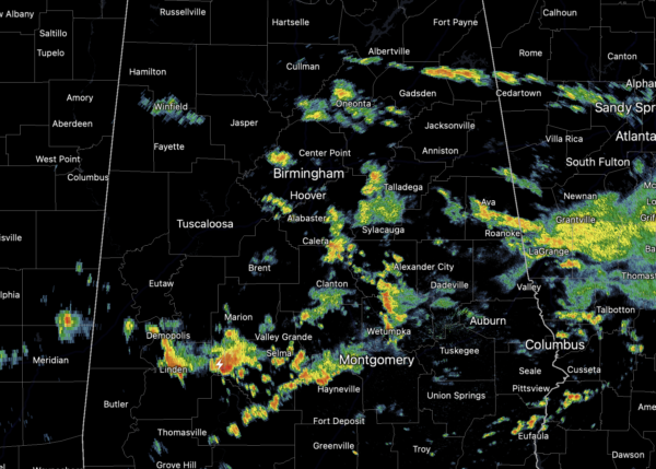
The surface front is dropping through Alabama today allowing for all the widespread rain and storms across the state. The radar has been active this morning, and will continue to be so through the afternoon. Due to the clouds and rain, temperatures are mainly in the upper 70s and low 80s across the state. The rain will end later this evening from north to south as the front moves south.
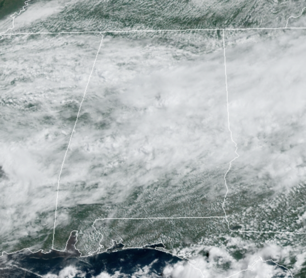
INDEPENDENCE WEEKEND WEATHER: The front pushes down into South Alabama tonight taking the rain and storms with it. Along and south of the front, rain and storms will be common over the weekend from Mobile over the Panama City, if you are beachbound this weekend, be prepared for rain and storms at times. For the northern two-thirds of the state, unseasonably dry air for summer settles in, allowing for ample sunshine and lower humidity levels. Highs will be in the 80s, while nights will be very comfortable with widespread 60s and 50s.
HURRICANE ELSA: Late morning update: The center of Hurricane Elsa was located near latitude 13.4 North, longitude 61.2 West. Elsa is moving toward the west-northwest near 29 mph, and this motion is expected to continue during the next couple of days, with some decrease in forward speed expected Sunday night. On the forecast track, Elsa will move away from the Windward Islands during the next several hours, move across the eastern Caribbean Sea later today and tonight, and move near the southern coast of Hispaniola late Saturday or Saturday night. By Sunday, Elsa is forecast to move near Jamaica and portions of eastern Cuba, and move near portions of central and western Cuba Sunday night and early Monday. Beyond that, it looks to eye the Gulf Coast side of the Florida Peninsula late Tuesday.

Maximum sustained winds are near 75 mph with higher gusts. Little change in strength is forecast during the next 48 hours. Some decrease in winds is possible on Monday as Elsa interacts with Cuba. Hurricane-force winds extend outward up to 25 miles from the center and tropical-storm-force winds extend outward up to 140 miles. The Hewanorra Airport on St. Lucia recently reported sustained winds of 46 mph with a wind gust of 79 mph The estimated minimum central pressure is 995 mb (29.39 inches).
BEACH FORECAST CENTER: Get the latest weather and rip current forecasts for the beaches from Fort Morgan to Panama City on our Beach Forecast Center page. There, you can select the forecast of the region that you are interested in visiting.
WORLD TEMPERATURE EXTREMES: Over the last 24 hours, the highest observation outside the U.S. was 128.3F at Jahra, Kuwait. The lowest observation was -104.3F at Vostok, Antarctica.
CONTIGUOUS TEMPERATURE EXTREMES: Over the last 24 hours, the highest observation was 117F at Death Valley, CA. The lowest observation was 30F at Peter Sinks, UT.
Category: Alabama's Weather, ALL POSTS
About the Author (Author Profile)
Macon, Georgia Television Chief Meteorologist, Birmingham native, and long time Contributor on AlabamaWX. Stormchaser. I did not choose Weather, it chose Me. College Football Fanatic. @Ryan_StinnetSubscribe
If you enjoyed this article, subscribe to receive more just like it.


