Elsa Slightly Weakens for Now, Expected to Reintensify by Late Saturday
SUMMARY OF 10 PM CDT…0300 UTC…INFORMATION
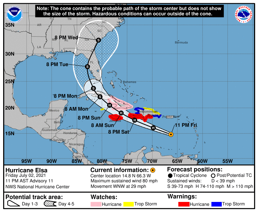
LOCATION…14.8N 66.3W
ABOUT 395 MI…635 KM ESE OF ISLA BEATA, DOMINICAN REPUBLIC
ABOUT 730 MI…1175 KM ESE OF KINGSTON, JAMAICA
MAXIMUM SUSTAINED WINDS…80 MPH…130 KM/H
PRESENT MOVEMENT…WNW OR 285 DEGREES AT 29 MPH…46 KM/H
MINIMUM CENTRAL PRESSURE…995 MB…29.39 INCHES
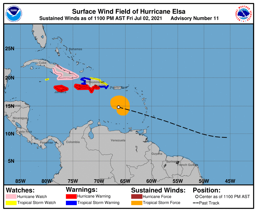
WATCHES AND WARNINGS
A Hurricane Warning is in effect for…
* Southern coast of the Dominican Republic from Punta Palenque to the border with Haiti
* Southern portion of Haiti from Port-au-Prince to the southern border with the Dominican Republic
* Jamaica
A Tropical Storm Warning is in effect for…
* The coast of Haiti north of Port-au-Prince
* South coast of the Dominican Republic east of Punta Palenque to Cabo Engano
A Hurricane Watch is in effect for…
* The Cuban provinces of Camaguey, Granma, Guantanamo, Holguin, Las Tunas, and Santiago de Cuba
A Tropical Storm Watch is in effect for…
* North coast of the Dominican Republic from Cabo Engano to Bahia de Manzanillo
* Cayman Brac and Little Cayman
FORECAST DISCUSSION
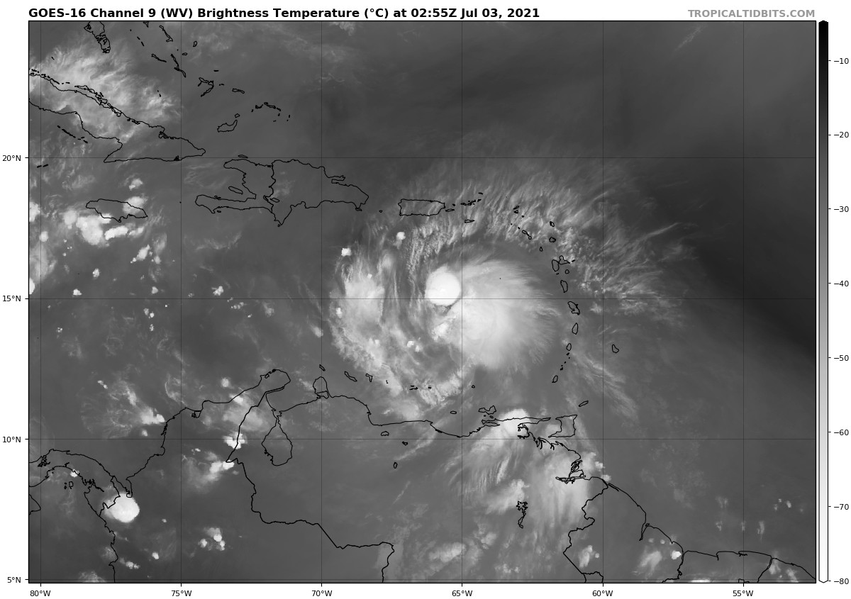
Data from an Air Force Reserve hurricane hunter aircraft indicate that Elsa has weakened slightly, and that the flight-level and surface centers are not vertically aligned. The maximum 700-mb wind speed measured was 75 kt, and the highest SFMR surface wind sampled was 61 kt in the northeastern quadrant. However, these data were collected outside of the strongest convection that was occurring just east of the flight track, so the intensity has only been lowered to 70 kt, which is supported by the slightly higher central pressure of 995 mb sampled by a dropsonde.
The initial motion estimate now is 285/25 kt. There remains little significant change to the previous track forecast or reasoning. The latest 00Z model guidance has become more convergent and now lies nearly on top of the previous advisory track. Over the last 48 h, the ECMWF model has steadily shifted Elsa’s track westward by about 1 degree of longitude each model cycle, with the latest ECMWF forecast track now being located about 240 nmi west of its forecast track two days ago. As a result, less weight has been placed on the ECMWF solution for this advisory. However, even its latest solution no longer takes Elsa over the heart of Hispaniola. Elsa should continue to move generally west-northwestward for the next 48 h, accompanied by a slow but steady decrease in forward speed. By the time the hurricane nears southern Cuba, the forward speed should be less than 15 kt. Thereafter, Elsa should gradually turn northwestward and eventually northward through a developing weakness in the subtropical ridge This motion should take Elsa across Cuba and over the eastern Gulf of Mexico or the nearby Florida Peninsula on day 4, followed by a motion over the coastal regions of the southeastern United States on day 5. The new NHC forecast track is essentially just an update of the previous advisory, and closely follows a blend of the GFS, UKMET, and HWRF models, and the TVCA simple consensus model.
Elsa’s fast forward speed and recent entrainment of dry mid-level air into the western semicircle has eroded some of the inner-core convection, resulting in the aforementioned weakening. In fact, NOAA G-IV dropsondes launched around 2100 UTC northwest of Elsa indicated a significant dry-air layer between 400-500-hPa that may have been imported by moderate northwesterly mid-level shear. However, as the cyclone’s forward speed steadily decreases, the low-, mid-, and upper-level circulations should become more vertically aligned, which should allow for at least some slight re-strengthening during the next 24 h or so. Possible interaction with the landmasses of Haiti, southeastern Cuba, and Jamaica is the primary reason for not showing a more robust intensity forecast, given the very warm water beneath the hurricane and a very favorable upper-level wind flow regime. The latest GFS and UKMET models indicate that Elsa will be moving into the center of a 300-200-mb synoptic-scale anticyclone, which would produce enhanced outflow jets to the north and south of the cyclone, resulting in significant strengthening. If Elsa ends up ‘threading-the-needle’ between Haiti, Jamaica, and Cuba, then subsequent intensity forecasts may have to be increased similar to the much stronger HWRF model. For now, the official NHC intensity forecast maintains continuity with the previous advisory, and shows only slight re-strengthening due to possible interaction with land.
It should be noted that the average NHC track errors are 175 miles and 200 miles at days 4 and 5, respectively. Given the larger-than-normal uncertainty and because hazards will extend well away from the center of the storm, users are urged to not focus on the exact forecast points.
KEY MESSAGES
1. Hurricane conditions and dangerous storm surge are expected within the Hurricane Warning areas in Haiti and the Dominican Republic beginning Saturday, and in Jamaica beginning Sunday.
2. The outer rain bands from Elsa will impact Puerto Rico by late tonight, with widespread heavy rain moving into southern Hispaniola and Jamaica Saturday into Sunday. Isolated to scattered flash flooding and mudslides are possible. Through early next week, heavy rain is expected to impact the Cayman Islands and Cuba, resulting in significant flooding with mudslides possible in Cuba.
3. Hurricane conditions and dangerous storm surge are possible in portions of eastern Cuba beginning early Sunday, where a Hurricane Watch is in effect. There is an increasing risk of wind, storm surge, and rainfall impacts elsewhere in Cuba Sunday and Monday.
4. There is an increasing risk of storm surge, wind, and rainfall impacts beginning Monday in the Florida Keys and spreading northward along the Florida Peninsula through Tuesday. However, the forecast uncertainty remains larger than usual due to Elsa’s potential interaction with the islands of Hispaniola and Cuba this weekend. Interests throughout Florida should monitor Elsa’s progress and updates to the forecast.
Category: ALL POSTS, Severe Weather, Tropical
About the Author (Author Profile)
Scott Martin is an operational meteorologist, professional graphic artist, musician, husband, and father. Not only is Scott a member of the National Weather Association, but he is also the Central Alabama Chapter of the NWA president. Scott is also the co-founder of Racecast Weather, which provides forecasts for many racing series across the USA. He also supplies forecasts for the BassMaster Elite Series events including the BassMaster Classic.Subscribe
If you enjoyed this article, subscribe to receive more just like it.


