7 pm Update: Elsa Passing Just East of Havana, Cuba; Expected to Move Near the Florida Keys on Tuesday
SUMMARY OF 7 PM CDT…0000 UTC…INFORMATION
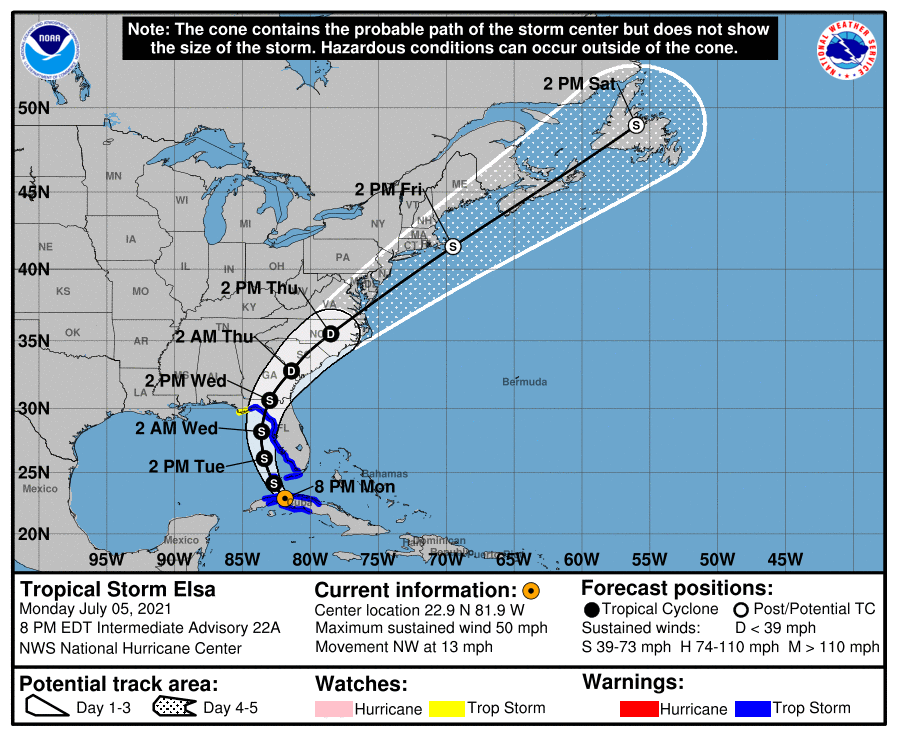
LOCATION…22.9N 81.9W
ABOUT 30 MI…50 KM E OF HAVANA CUBA
ABOUT 115 MI…185 KM S OF KEY WEST FLORIDA
MAXIMUM SUSTAINED WINDS…50 MPH…85 KM/H
PRESENT MOVEMENT…NW OR 325 DEGREES AT 13 MPH…20 KM/H
MINIMUM CENTRAL PRESSURE…1008 MB…29.77 INCHES
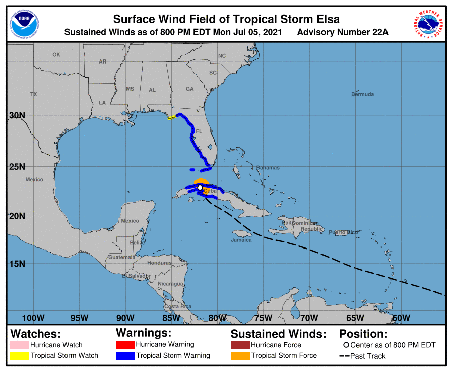
WATCHES AND WARNINGS
A Storm Surge Warning is in effect for…
* West coast of Florida from Bonita Beach to the Aucilla River including Tampa Bay
A Tropical Storm Warning is in effect for…
* The Cuban provinces of Cienfuegos, Matanzas, Villa Clara, Mayabeque, Havana, and Artemisa
* The Florida Keys from Craig Key westward to the Dry Tortugas
* West coast of Florida from Flamingo northward to Ochlockonee River
A Storm Surge Watch is in effect for…
* West of the Aucilla River to the Ochlockonee River
A Tropical Storm Watch is in effect for…
* West of the Ochlockonee River to Indian Pass, Florida
DISCUSSION AND OUTLOOK
At 800 PM EDT (0000 UTC), the center of Tropical Storm Elsa was located by radars from Key West, Florida, and Havana, Cuba, near latitude 22.9 North, longitude 81.9 West. Elsa is moving toward the northwest near 13 mph (20 km/h), and this general motion is expected to continue tonight, followed by a turn toward the north-northwest on Tuesday, and a turn toward the north on Tuesday night. A north-northeastward motion is expected on Wednesday. On the forecast track, Elsa should emerge off the coast western Cuba during the next hour or so, move into the Florida Straits this evening, and pass near the Florida Keys early Tuesday. Elsa is then forecast to move near or over portions of the west coast of Florida by late Tuesday and continuing into Wednesday.
Data from the NOAA Doppler weather radar in Key West indicate that maximum sustained winds are near 50 mph (85 km/h) with higher gusts over water. Some restrengthening is forecast after Elsa moves over the Straits of Florida tonight and over the Gulf of Mexico on Tuesday. An Air Force Reserve reconnaissance aircraft is en route to investigate Elsa once the storm moves back over water.
Tropical-storm-force winds extend outward up to 70 miles (110 km), mainly north through northeast of the center. The estimated minimum central pressure is 1008 mb (29.77 inches).
HAZARDS AFFECTING LAND
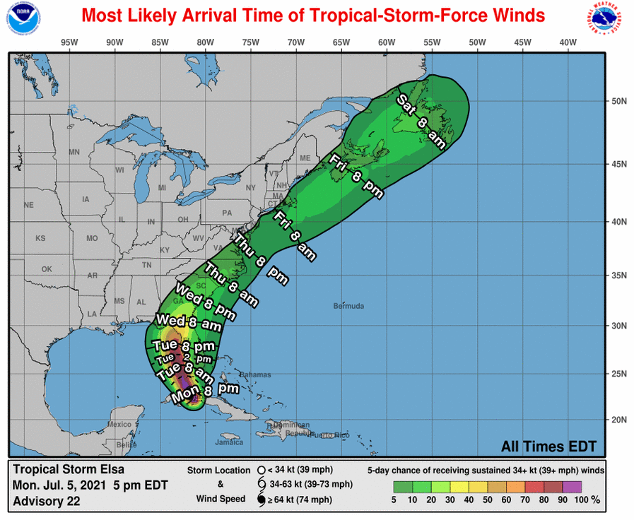
WIND: Tropical storm conditions should continue over portions of central and western Cuba for the next several hours. Tropical storm conditions are expected in the warning area in the Florida Keys beginning tonight and along the Florida west coast beginning Tuesday. Tropical storm conditions are expected to spread northward into the Florida Big Bend region within the Tropical Storm Warning area Tuesday night and early Wednesday. Tropical storm conditions are possible in the watch area beginning late Tuesday night.
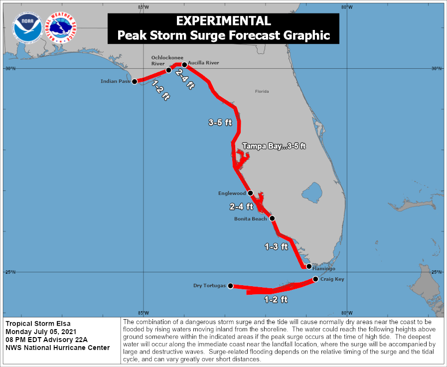
STORM SURGE: A storm surge will raise water levels above normal tide levels by as much as the following amounts in areas of onshore winds within the Tropical Storm Warning areas…
* Southern coast of Cuba…2 to 4 ft
The combination of a storm surge and the tide will cause normally dry areas near the coast to be flooded by rising waters moving inland from the shoreline. The water could reach the following heights above ground somewhere in the indicated areas if the peak surge occurs at the time of high tide…
* Englewood, FL to Aucilla River including Tampa Bay…3 to 5 ft
* Bonita Beach, FL to Englewood, FL including Charlotte Harbor…2 to 4 ft
* Aucilla River to Ochlockonee River…2 to 4 ft
* Flamingo, FL to Bonita Beach, FL…1 to 3 ft
* Craig Key, FL to Dry Tortugas…1 to 2 ft
* Ochlockonee River to Indian Pass…1 to 2 ft
Surge-related flooding depends on the relative timing of the surge and the tidal cycle, and can vary greatly over short distances.
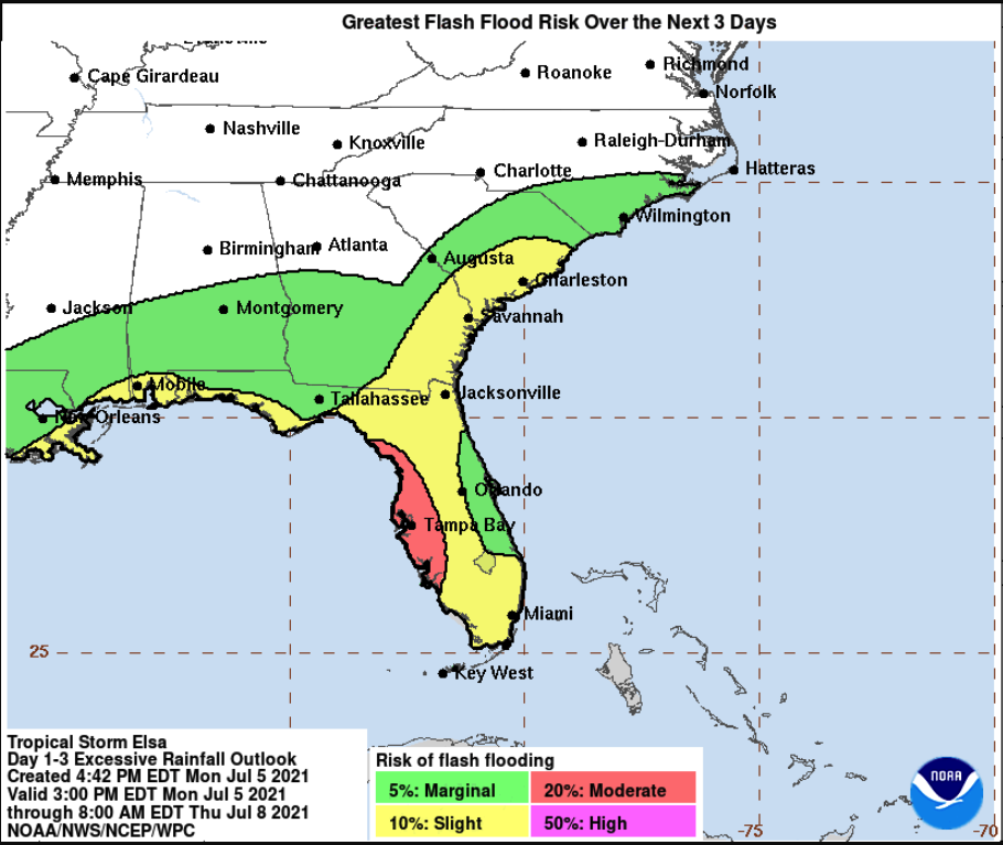
RAINFALL: Across portions of Cuba tonight, rainfall of 5 to 10 inches with isolated maximum amounts of 15 inches is expected. This will result in significant flash flooding and mudslides. Across the Cayman Islands tonight, rainfall of 3 to 5 inches is expected. This rain may lead to scattered flash flooding.
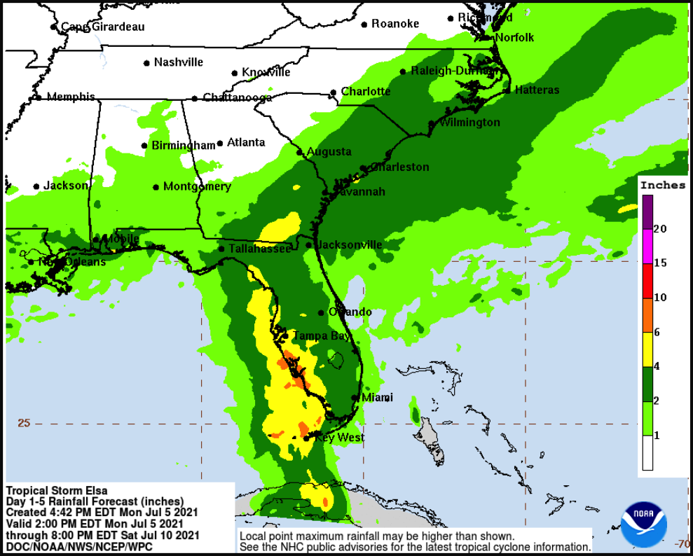
Elsa is expected to produce the following rainfall amounts and impacts this week:
Across the Keys into southwest and western portions of the Florida Peninsula…3 to 5 inches with localized maximum totals up to 8 inches through Wednesday, which may result in considerable flash and urban flooding, along with minor to isolated moderate river flooding.
Across the rest of Florida into southeast Georgia and the Low Country of South Carolina…2 to 4 inches with localized maximum totals up to 6 inches through Wednesday night, which may result in isolated flash, urban, and minor river flooding.
Across coastal portions of North Carolina into southeastern Virginia…1 to 3 inches with isolated totals up to 5 inches Wednesday night through Thursday night, which could lead to isolated flash and urban flooding.
TORNADOES: A few tornadoes are possible across south Florida tonight and across the Florida Peninsula on Tuesday.
SURF: Swells generated by Elsa will spread westward along the southern coast of Cuba tonight. Swells will increase near the Florida Keys and south Florida tonight and spread northward along the west coast of Florida tonight through Tuesday night.
Category: ALL POSTS, Severe Weather, Tropical
About the Author (Author Profile)
Scott Martin is an operational meteorologist, professional graphic artist, musician, husband, and father. Not only is Scott a member of the National Weather Association, but he is also the Central Alabama Chapter of the NWA president. Scott is also the co-founder of Racecast Weather, which provides forecasts for many racing series across the USA. He also supplies forecasts for the BassMaster Elite Series events including the BassMaster Classic.Subscribe
If you enjoyed this article, subscribe to receive more just like it.


