Midday Nowcast: Rain Chances on the Rise
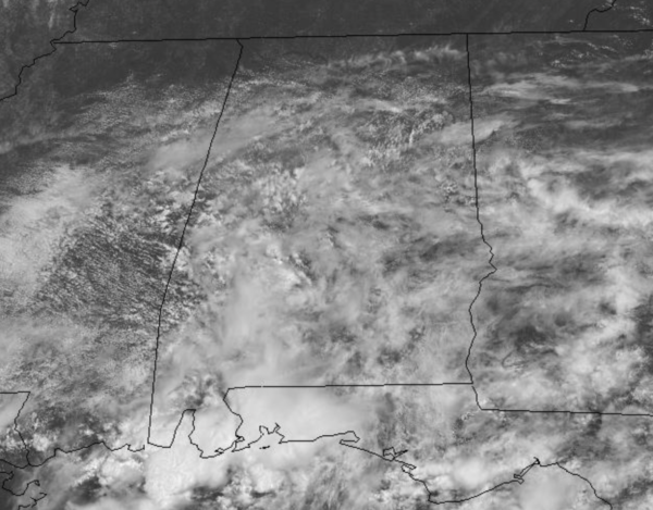
Moisture levels are on the rise today as a warm front lifts north through the state. Clouds are increasing and showers and storms are returning to the area as we head into the afternoon hours. Temperatures top out in the mid and upper 80s across North/Central Alabama later today. Tonight will be mainly cloudy with some scattered showers.
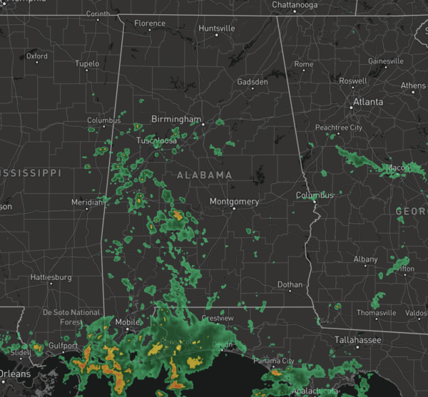
REST OF WEEK: High moisture levels will remain in place and with a nearby upper trough, widespread and numerous showers and storms are the main features in our weather forecast tomorrow and Thursday. Due to the clouds and rain, highs will be in the upper 70s to lower 80s these days, which are well-below average for July in Alabama. By Friday, rain chances should decrease a bit, but we will continue to mention scattered showers and storms in the forecast; highs should return to the mid and upper 80s.
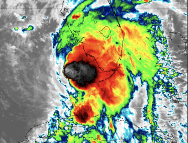
LATEST ON ELSA: The center of Tropical Storm Elsa was located near latitude 24.9 North, longitude 82.8 West. Elsa is moving toward the north-northwest near 10 mph and a generally northward motion is expected today and tonight. A turn toward the north-northeast is expected on Wednesday, followed by a faster northeastward by late Thursday. On the forecast track, Elsa will continue to pass near the Florida Keys this morning, and move near or over portions of the west coast of Florida later today through tonight. On Wednesday morning, Elsa is forecast to make landfall along the north Florida Gulf coast and then move across the southeastern United States through Thursday.
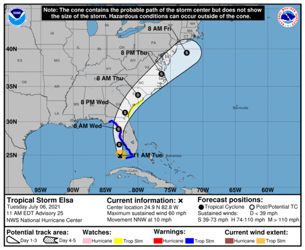
Maximum sustained winds are near 60 mph with higher gusts. Slow strengthening is forecast through tonight, and Elsa could be near hurricane strength before it makes landfall in Florida. Weakening is expected after Elsa moves inland. Tropical-storm-force winds extend outward up to 70 miles from the center. A C-MAN station at Sand Key, Florida, recently measured a peak 1-minute sustained wind of 56 mph gusting to 64 mph. The Key West International Airport also recently measured a peak sustained wind of 43 mph gusting to 59 mph. The estimated minimum central pressure is 1007 mb (29.74 inches).
KEY MESSAGES:
WIND: Tropical storm conditions will continue over portions of the warning area in the Florida Keys through this evening. Tropical storm conditions are expected to spread northward into west-central Florida and the Florida Big Bend region tonight and early Wednesday, where hurricane conditions are possible. Tropical storm conditions are possible in the watch area in Georgia and South Carolina Wednesday night and early Thursday.
STORM SURGE: The combination of a storm surge and the tide will cause normally dry areas near the coast to be flooded by rising waters moving inland from the shoreline as a surge of 3 to 5 feet should be common. Surge-related flooding depends on the relative timing of the surge and the tidal cycle, and can vary greatly over short distances.
RAINFALL: Across the Florida Keys into southwest and western portions of the Florida Peninsula…3 to 5 inches. Across the rest of Florida…2 to 4 inches with localized maximum totals up to 6 inches through Wednesday night, which may result in isolated flash, urban, and minor river flooding.
Across portions of southeast Georgia and the Lowcountry of South Carolina, 3 to 5 inches with isolated maximum totals up to 8 inches will be possible, which may result in considerable flash and urban flooding. Across coastal portions of North Carolina into southeastern Virginia…1 to 3 inches with isolated totals up to 5 inches Wednesday night through Thursday night, which could lead to isolated flash and urban flooding..
TORNADOES: A few tornadoes are possible today through tonight across the Florida Peninsula. The tornado threat will continue on Wednesday across north Florida, southeast Georgia, and the Lowcountry of South Carolina. The tornado threat should shift to the easternCarolinas and far southeast Virginia on Thursday.
SURF: Swells will spread northward across portions of the Florida Keys and the west coast of Florida through early Wednesday. Theseswells are likely to cause life-threatening surf and rip current conditions.
Though Elsa will remain east of Alabama, and we expect little to no impacts from the system, we will mention rip currents in the Gulf will be running high this week, with the system in the Gulf. Just be mindful of that and pay attention to the flag warning system along the Gulf.
BEACH FORECAST CENTER: Get the latest weather and rip current forecasts for the beaches from Fort Morgan to Panama City on our Beach Forecast Center page. There, you can select the forecast of the region that you are interested in visiting.
WORLD TEMPERATURE EXTREMES: Over the last 24 hours, the highest observation outside the U.S. was 121.5F at Hassi-Messaoud, Algeria. The lowest observation was -88.6F at Concordia, Antarctica.
CONTIGUOUS TEMPERATURE EXTREMES: Over the last 24 hours, the highest observation was 120F at Death Valley, CA. The lowest observation was 32F at Wolcott, CO.
WEATHER ON THIS DATE IN 1893: A violent tornado killed 71 persons on its forty-mile track across northwestern Iowa. Forty-nine persons were killed around Pomeroy, where eighty percent of the buildings were destroyed, with most leveled to the ground. Photos showed most of the town without a wall or tree left standing.
Category: Alabama's Weather, ALL POSTS
About the Author (Author Profile)
Macon, Georgia Television Chief Meteorologist, Birmingham native, and long time Contributor on AlabamaWX. Stormchaser. I did not choose Weather, it chose Me. College Football Fanatic. @Ryan_StinnetSubscribe
If you enjoyed this article, subscribe to receive more just like it.


