7 pm Update: Elsa Has Restrengthened Into a Hurricane
SUMMARY OF 7 PM CDT…0000 UTC…INFORMATION
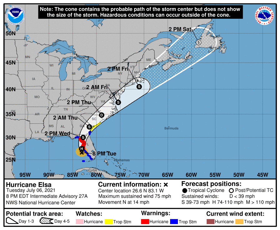
LOCATION…26.6N 83.1W
ABOUT 100 MI…165 KM SSW OF TAMPA FLORIDA
MAXIMUM SUSTAINED WINDS…75 MPH…120 KM/H
PRESENT MOVEMENT…N OR 360 DEGREES AT 14 MPH…22 KM/H
MINIMUM CENTRAL PRESSURE…996 MB…29.41 INCHES
WATCHES AND WARNINGS
A Storm Surge Warning is in effect for…
* West coast of Florida from Bonita Beach to the Aucilla River, including Tampa Bay
A Hurricane Warning is in effect for…
* Egmont Key to the Steinhatchee River, Florida
A Tropical Storm Warning is in effect for…
* The Dry Tortugas
* West coast of Florida from Flamingo to south of Egmont Key
* West coast of Florida north of Steinhatchee River to Ochlockonee River
* Coast of Georgia from the Mouth of the St. Marys River to Altamaha Sound
A Storm Surge Watch is in effect for…
* West of the Aucilla River to the Ochlockonee River, Florida
A Tropical Storm Watch is in effect for…
* North of Altamaha Sound, Georgia, to South Santee River, South Carolina
DISCUSSION AND OUTLOOK
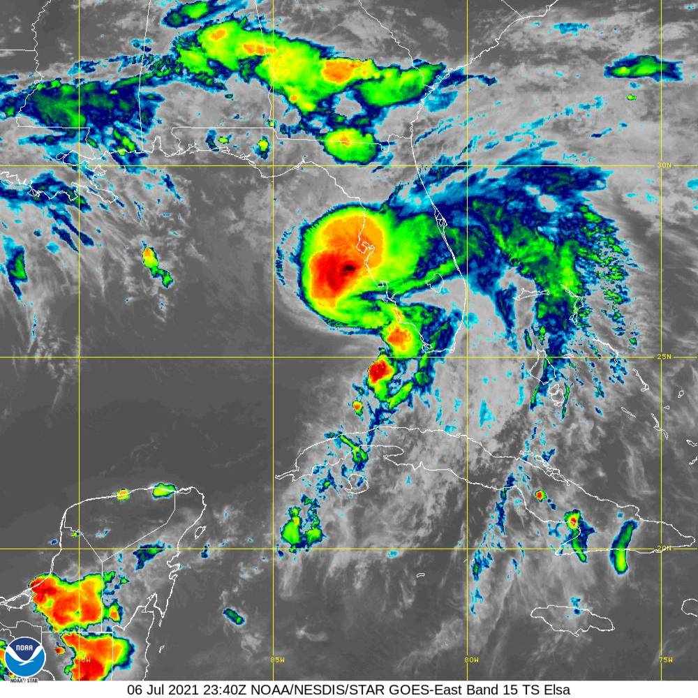
At 800 PM EDT (0000 UTC), the center of Hurricane Elsa was located by NOAA Doppler weather radars near latitude 26.6 North, longitude 83.1 West. Elsa is moving toward the north near 10 mph (22 km/h), and this general motion is expected to continue through tonight. A turn toward the north-northeast is expected on Wednesday, followed by a faster northeastward motion by late Thursday. On the forecast track, Elsa will move near or over portions of the west coast of Florida later tonight and early Wednesday morning. Elsa is forecast to make landfall along the north Florida Gulf coast by late Wednesday morning and then move across the southeastern United States through Thursday.
Data from the NOAA Doppler weather radar in Tampa Bay indicate that maximum sustained winds are near 75 mph (120 km/h) with higher gusts. Some additional slight strengthening will be possible overnight. Weakening will begin after Elsa moves inland by late Wednesday morning.
Tropical-storm-force winds extend outward up to 90 miles (150 km) from the center. Buoy 42013, located due north of Elsa, recently measured a peak 1-minute sustained wind of 38 mph (61 km/h) gusting to 47 mph (76 km/h). A wind gust to 43 mph (69 mph) was recently measured on North Captiva Island. The estimated minimum central pressure is 996 mb (29.41 inches).
HAZARDS AFFECTING LAND
WIND: Hurricane conditions are expected within the Hurricane Warning area on the Florida Gulf coast beginning this evening. Tropical storm conditions will continue over portions of the warning area in the Florida Keys through this evening. Tropical storm conditions are expected to spread northward into west-central Florida and the Florida Big Bend region in the warning areas tonight and early Wednesday. Tropical storm conditions are expected in the Tropical Storm Warning area along the Georgia coast by late Wednesday and are possible in the watch area in Georgia and South Carolina Wednesday night and early Thursday.
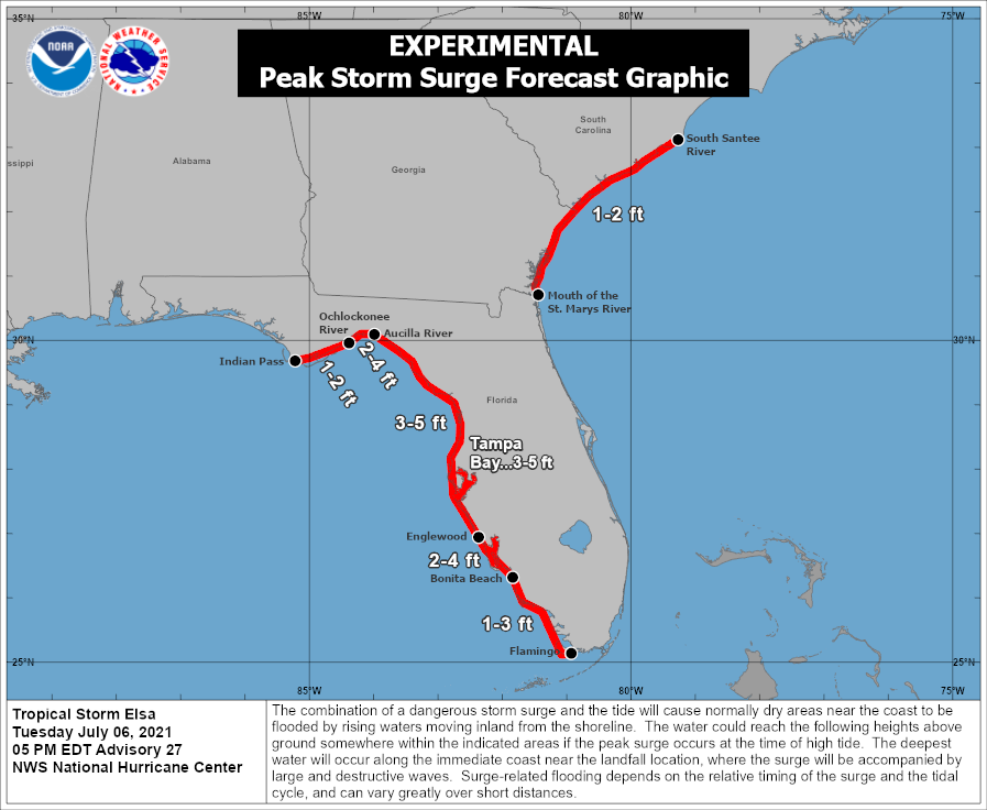
STORM SURGE: The combination of a storm surge and the tide will cause normally dry areas near the coast to be flooded by rising waters moving inland from the shoreline. The water could reach the following heights above ground somewhere in the indicated areas if the peak surge occurs at the time of high tide…
Englewood, FL to Aucilla River including Tampa Bay…3 to 5 ft
Bonita Beach, FL to Englewood, FL including Charlotte Harbor…2 to 4 ft
Aucilla River to Ochlockonee River…2 to 4 ft
Flamingo, FL to Bonita Beach, FL…1 to 3 ft
Ochlockonee River to Indian Pass…1 to 2 ft
Mouth of St. Marys River to South Santee River, SC…1 to 2 ft
Surge-related flooding depends on the relative timing of the surge and the tidal cycle, and can vary greatly over short distances. For information specific to your area, please see products issued by your local National Weather Service forecast office.
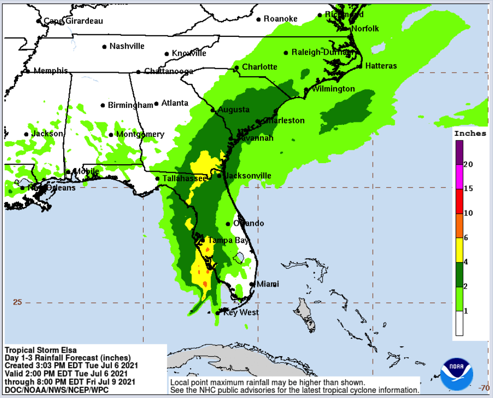
RAINFALL: Across portions of Cuba through tonight, outer bands south of Elsa will produce an additional 1 to 3 inches of rainfall. Isolated storm totals of 15 inches are expected, which will maintain areas of significant flash flooding and mudslides through tonight.
Elsa is expected to produce the following rainfall amounts and impacts this week:
Across the Florida Keys into southwest and western portions of the Florida Peninsula…3 to 6 inches with localized maximum totals up to 9 inches through Wednesday, which may result in considerable flash and urban flooding, along with minor to isolated moderate river flooding.
Across the rest of Florida…2 to 4 inches with localized maximum totals up to 6 inches through Wednesday night, which may result in considerable isolated flash and urban flooding along with minor to isolated moderate river flooding.
Across portions of southeast Georgia and the Lowcountry of South Carolina, 3 to 5 inches with isolated maximum totals up to 8 inches will be possible, which may result in considerable flash and urban flooding.
Across coastal portions of North Carolina into southeastern Virginia…1 to 3 inches with isolated totals up to 5 inches Wednesday night through Thursday night, which could lead to isolated flash and urban flooding.
TORNADOES: A few tornadoes are possible through tonight across the Florida Peninsula. The tornado threat will continue on Wednesday across north Florida, southeast Georgia, and the Lowcountry of South Carolina. The tornado threat should shift to the eastern Carolinas and far southeast Virginia on Thursday.
SURF: Swells will spread northward across portions of the Florida Keys and the west coast of Florida through early Wednesday. These swells are likely to cause life-threatening surf and rip current conditions. Please consult products from your local weather office for more details.
All images, forecasts, and documents are courtesy of their respective publishers.
Category: ALL POSTS, Severe Weather, Tropical
About the Author (Author Profile)
Scott Martin is an operational meteorologist, professional graphic artist, musician, husband, and father. Not only is Scott a member of the National Weather Association, but he is also the Central Alabama Chapter of the NWA president. Scott is also the co-founder of Racecast Weather, which provides forecasts for many racing series across the USA. He also supplies forecasts for the BassMaster Elite Series events including the BassMaster Classic.Subscribe
If you enjoyed this article, subscribe to receive more just like it.


