7 a.m. Advisory: Elsa Nearing Landfall
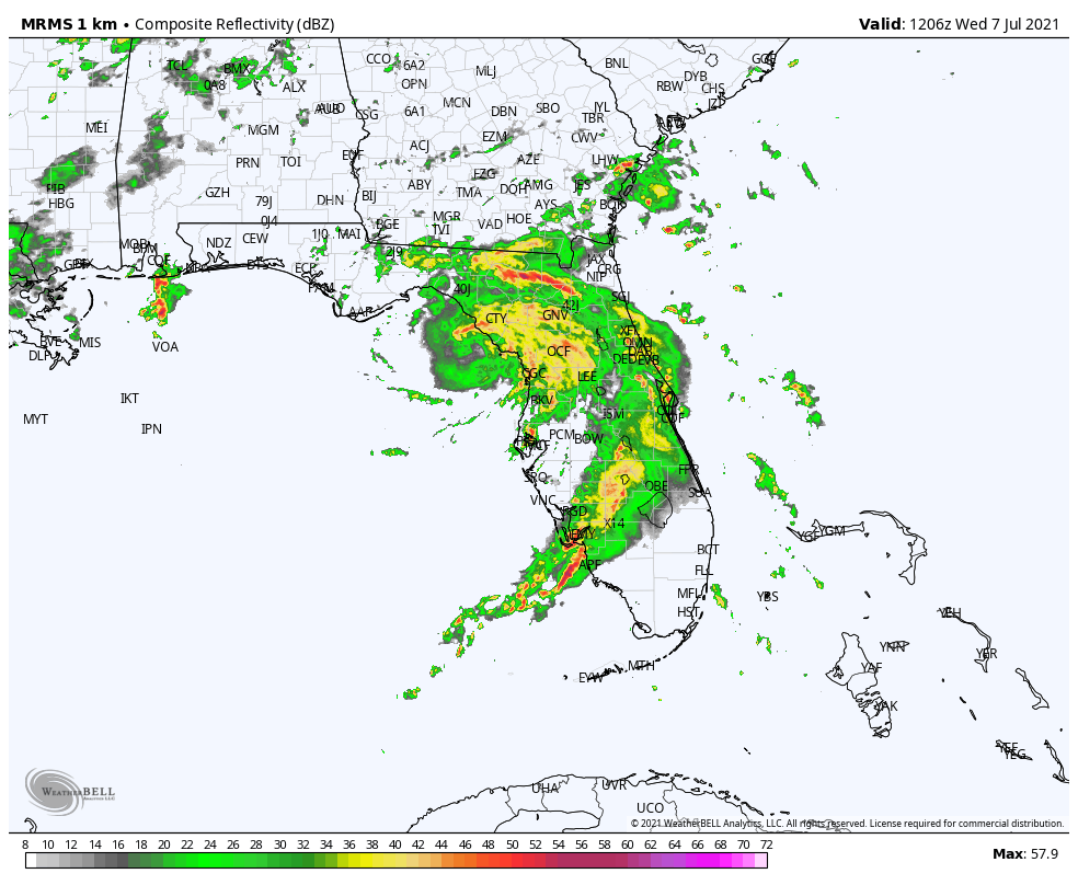
After weakening some overnight and being downgraded back to a tropical storm, Elsa has re-intensified a bit this morning with increased convection appearing.
Air Force recon found a minimum surface pressure of 999 millibars. Max winds are at 65 mph.
The system jogged a bit to the west this morning but is expected to begin the turn to the north northeast this morning. It will make landfall in Taylor or Dixie County Florida in the Florida Big Bend around 9-10 a.m.
A 56 mph wind gust was reported at Cedar Key just before 6 a.m. CDT. Tampa was reporting winds SE at 14 gusting to 26 mph. CLearwater Beach had a wind gust to 36 knots or 42 mph.
A storm surge of 1.6 feet was being reported at Cedar Key. Surge levels could reach 3 to 5 ft from the Anclote River to Aucilla River.
There were several tornado warnings earlier this morning from near Gainesville to south of Lake City in one of the feeder bands. There is a tornado watch for northeastern Florida and southeastern Georgia.
Here is the full text of the advisory:
BULLETIN
Tropical Storm Elsa Intermediate Advisory Number 29A
NWS National Hurricane Center Miami FL AL052021
800 AM EDT Wed Jul 07 2021
…ELSA APPROACHING THE NORTHERN FLORIDA GULF COAST…
SUMMARY OF 800 AM EDT…1200 UTC…INFORMATION
———————————————-
LOCATION…29.2N 83.6W
ABOUT 35 MI…55 KM W OF CEDAR KEY FLORIDA
ABOUT 115 MI…185 KM NW OF TAMPA FLORIDA
MAXIMUM SUSTAINED WINDS…65 MPH…100 KM/H
PRESENT MOVEMENT…N OR 360 DEGREES AT 14 MPH…22 KM/H
MINIMUM CENTRAL PRESSURE…999 MB…29.50 INCHES
WATCHES AND WARNINGS
——————–
CHANGES WITH THIS ADVISORY:
The Tropical Storm and Storm Surge Warnings have been discontinued
south of the Middle of Longboat Key.
SUMMARY OF WATCHES AND WARNINGS IN EFFECT:
A Storm Surge Warning is in effect for…
* West coast of Florida from the Middle of Longboat Key to the
Aucilla River, including Tampa Bay
A Hurricane Warning is in effect for…
* West coast of Florida from Chassahowitzka to the Steinhatchee
River
A Tropical Storm Warning is in effect for…
* West coast of Florida from south of Chassahowitzka to the Middle
of Longboat Key
* West coast of Florida north of the Steinhatchee River to
Ochlockonee River
* Mouth of St. Marys River, Georgia to Little River Inlet, South
Carolina
A Storm Surge Watch is in effect for…
* West of the Aucilla River to the Ochlockonee River, Florida
A Tropical Storm Watch is in effect for…
* North of Little River Inlet, South Carolina to Chincoteague,
Virginia
* Pamlico and Albemarle Sounds
A Storm Surge Warning means there is a danger of life-threatening
inundation, from rising water moving inland from the coastline,
in the indicated locations. For a depiction of areas at risk,
please see the National Weather Service Storm Surge Watch/Warning
Graphic, available at hurricanes.gov. This is a life-threatening
situation. Persons located within these areas should take all
necessary actions to protect life and property from rising water
and the potential for other dangerous conditions. Promptly follow
evacuation and other instructions from local officials.
A Tropical Storm Warning means that tropical storm conditions are
expected somewhere within the warning area.
A Storm Surge Watch means there is a possibility of life-
threatening inundation, from rising water moving inland from the
coastline, in the indicated locations. For a depiction of areas at
risk, please see the National Weather Service Storm Surge
Watch/Warning Graphic, available at hurricanes.gov.
A Tropical Storm Watch means that tropical storm conditions are
possible within the watch area.
Interests elsewhere in the Carolinas, the mid-Atlantic coast,
southeastern New England, and the Canadian Maritimes should
monitor the progress of Elsa.
For storm information specific to your area, including possible
inland watches and warnings, please monitor products issued by your
local National Weather Service forecast office.
DISCUSSION AND OUTLOOK
———————-
At 800 AM EDT (1200 UTC), the center of Tropical Storm Elsa was
located by an Air Force Hurricane Hunter aircraft and NWS
Doppler radars near latitude 29.2 North, longitude 83.6 West. Elsa
is moving toward the north near 14 mph (22 km/h), and a general
northward motion is expected to continue through this afternoon. A
turn toward the north-northeast is expected late this afternoon or
tonight, followed by a faster northeastward motion by late Thursday.
On the forecast track, Elsa will make landfall along the north
Florida Gulf coast by late this morning or this afternoon. The
storm should then move across the southeastern and mid-Atlantic
United States through Thursday.
Maximum sustained winds are near 65 mph (100 km/h) with higher
gusts. Little change in strength is likely until landfall later
today. Weakening will begin after Elsa moves inland later today.
Tropical-storm-force winds extend outward up to 90 miles (150 km)
from the center. A C-MAN station at Cedar Key, Florida, recently
measured a sustained wind of 41 mph (66 km/h) gusting to 51 mph (66
km/h).
The minimum central pressure estimated from Air Force Hurricane
Hunter observations is 999 mb (29.50 inches).
HAZARDS AFFECTING LAND
———————-
Key messages for Elsa can be found in the Tropical Cyclone
Discussion under AWIPS header MIATCDAT5, WMO header WTNT45 KNHC and
on the web at
www.hurricanes.gov/graphics_at5.shtml?key_messages.
WIND: Hurricane conditions could still occur in the hurricane
warning area this morning. Tropical storm conditions will continue
along the Gulf coast of Florida in the warning area today. Tropical
storm conditions are expected in the Tropical Storm Warning area
along the Georgia coast by late today or tonight and along the South
Carolina coast tonight and early Thursday. Tropical storm
conditions are possible in the watch area in the mid-Atlantic states
by Thursday night and Friday.
STORM SURGE: The combination of a storm surge and the tide will
cause normally dry areas near the coast to be flooded by rising
waters moving inland from the shoreline. The water could reach the
following heights above ground somewhere in the indicated areas if
the peak surge occurs at the time of high tide…
Anclote River to Aucilla River…3 to 5 ft
Middle of Longboat Key, FL to Anclote River including Tampa Bay…2
to 4 ft
Bonita Beach, FL to Middle of Longboat Key, FL including Charlotte
Harbor…1 to 3 ft
Aucilla River to Ochlockonee River…2 to 4 ft
Ochlockonee River to Indian Pass…1 to 2 ft
Mouth of St. Marys River to South Santee River, SC…1 to 2 ft
Surge-related flooding depends on the relative timing of the surge
and the tidal cycle, and can vary greatly over short distances. For
information specific to your area, please see products issued by
your local National Weather Service forecast office.
RAINFALL: Elsa is expected to produce the following rainfall amounts
and impacts the rest of this week:
Across western and northern portions of the Florida Peninsula…3 to
6 inches with localized maximum storm totals up to 9 inches today,
which may result in considerable flash and urban flooding, along
with minor to isolated moderate river flooding.
Across portions of southeast Georgia and the Lowcountry of South
Carolina, 2 to 4 inches with isolated maximum totals up to 6 inches
will be possible, which may result in considerable flash and urban
flooding.
Across coastal portions of North Carolina into southeastern
Virginia…1 to 3 inches with isolated totals up to 5 inches tonight
through Thursday night, which could lead to isolated flash and urban
flooding.
Across the Northeast and New England, 1 to 3 inches with isolated
totals up to 5 inches Thursday into Friday will be possible. This
could lead to isolated flash and urban flooding.
TORNADOES: A few tornadoes remain possible across west-central to
north Florida into this afternoon. The tornado threat will continue
later today through tonight across southeast Georgia and eastern
South Carolina. The tornado threat should shift to the eastern
Carolinas and far southeast Virginia on Thursday.
SURF: Swells will spread northward across portions of the west
coast of Florida through today. These swells are likely to cause
life-threatening surf and rip current conditions. Please consult
products from your local weather office for more details.
NEXT ADVISORY
————-
Next complete advisory at 1100 AM EDT.
$$
Forecaster Pasch/Papin/Brown
Category: Alabama's Weather, ALL POSTS, Tropical
About the Author (Author Profile)
Bill Murray is the President of The Weather Factory. He is the site's official weather historian and a weekend forecaster. He also anchors the site's severe weather coverage. Bill Murray is the proud holder of National Weather Association Digital Seal #0001 @wxhistorianSubscribe
If you enjoyed this article, subscribe to receive more just like it.


