4 pm Update: Elsa Moving Into Southern Georgia; Tornado Threat Continues
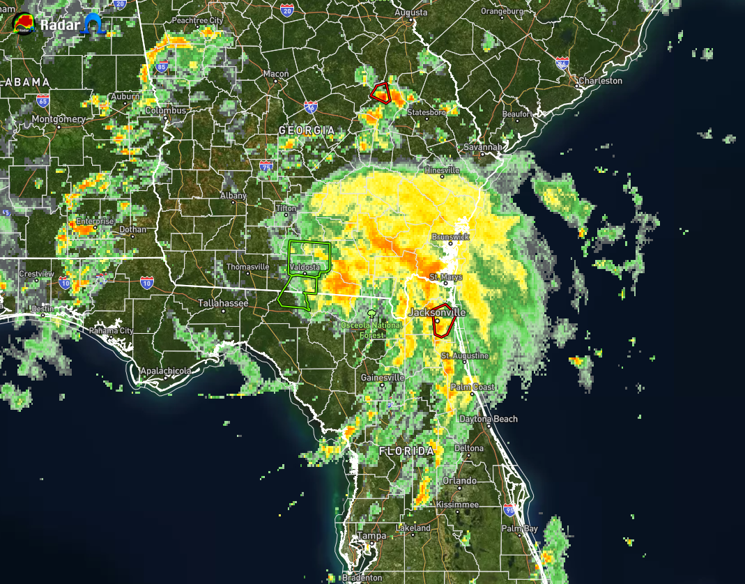
As of 3:50 pm, much of the shield of moderate to heavy tropical precipitation associated with Tropical Storm Elsa has moved into the southeastern portions of Georgia, with the trailing tails of showers and storms stretching back across northeastern Florida and down into the central portions of the peninsula.
A Tornado Warning was in effect until 5 pm EDT for eastern Duvall County, Florida, which includes the cities of Jacksonville, San Marco, Arlington, Fort Caroline, Craig Field, and Oceanway.
A Tornado Warning was in effect until 5 pm EDT for central Emanuel County, Georgia, but the storm is weakening below severe limits, and no longer appears capable of producing a tornado.
Here is the 4pm update from the National Hurricane Center:
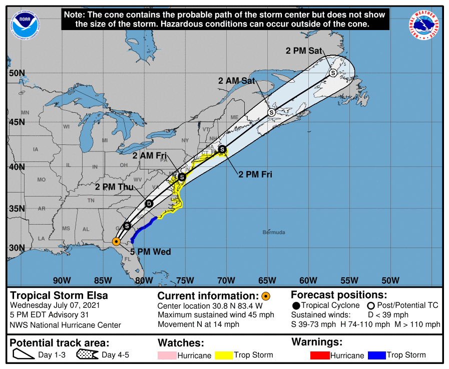
SUMMARY OF 4 PM CDT…2100 UTC…INFORMATION
LOCATION…30.8N 83.4W
ABOUT 115 MI…185 KM WSW OF BRUNSWICK GEORGIA
MAXIMUM SUSTAINED WINDS…45 MPH…75 KM/H
PRESENT MOVEMENT…N OR 10 DEGREES AT 14 MPH…22 KM/H
MINIMUM CENTRAL PRESSURE…1003 MB…29.62 INCHES
WATCHES AND WARNINGS
A Tropical Storm Warning is in effect for…
* Mouth of St. Marys River, Georgia to Little River Inlet, South Carolina
A Tropical Storm Watch is in effect for…
* North of Little River Inlet, South Carolina to Sandy Hook, New Jersey
* Pamlico and Albemarle Sounds
* Chesapeake Bay south of North Beach and the tidal Potomac south of Cobb Island
* Delaware Bay south of Slaughter Beach
* Long Island from East Rockaway Inlet to the eastern tip along the south shore and from Port Jefferson Harbor eastward on the north shore
* New Haven, Connecticut to Sagamore Beach, Massachusetts including Cape Cod, Block Island, Martha’s Vineyard, and Nantucket.
DISCUSSION AND OUTLOOK
Surface synoptic data indicate that the center of Elsa has moved into extreme southern Georgia and, assuming continued weakening since earlier today, the maximum winds are estimated to be 40 kt. This may be a generous estimate of the current intensity since no surface observations of sustained tropical-storm-force winds have been recently received. Elsa should weaken into a tropical depression on Thursday. By early Friday, the dynamical models show some restrengthening of the cyclone as it moves along the Mid-Atlantic coastline. However, the simulated satellite imagery from the global models at that time depict the system resembling a frontal cyclone, so it is dubious as to whether Elsa will be completely tropical in 48 hours. Due to the uncertainty as to when extratropical transition will occur, tropical storm watches have been issued for Long Island and portions of southern New England at this time.
The initial motion is northward, or 010/12 kt. Elsa is forecast to turn north-northeastward overnight as it moves around the northwestern periphery of an Atlantic subtropical ridge while accelerating northeastward ahead of a broad mid-level trough over the eastern United States and Canada on Thursday. The official forecast is about the same as the previous one and closely follows the multi-model consensus.
KEY MESSAGES
1. Heavy rainfall may result in considerable flash, urban, and isolated moderate river flooding over northern Florida. Heavy rainfall across southeast Georgia, South Carolina, North Carolina, and southeastern Virginia may result in considerable flash and urban flooding across southeast Georgia and the Lowcountry of South Carolina. Heavy rainfall across the Northeast and New England Thursday and Friday could lead to isolated flash and urban flooding.
2. Although the center of Elsa is expected to remain inland of the coastline from Georgia through the Carolinas during the next day or two, tropical storm conditions are expected along portions of the coasts of Georgia and South Carolina tonight. Tropical storm conditions are also possible along the coast of the mid-Atlantic and southern New England states by Thursday night or Friday.
All images, forecasts, and documents are courtesy of their respective publishers.
Category: ALL POSTS, Severe Weather, Tropical
About the Author (Author Profile)
Scott Martin is an operational meteorologist, professional graphic artist, musician, husband, and father. Not only is Scott a member of the National Weather Association, but he is also the Central Alabama Chapter of the NWA president. Scott is also the co-founder of Racecast Weather, which provides forecasts for many racing series across the USA. He also supplies forecasts for the BassMaster Elite Series events including the BassMaster Classic.Subscribe
If you enjoyed this article, subscribe to receive more just like it.


