10 pm Update: New Tropical Storm Warnings Issued for North Carolina and the Mid-Atlantic States
SUMMARY OF 10 PM CDT…0300 UTC…INFORMATION
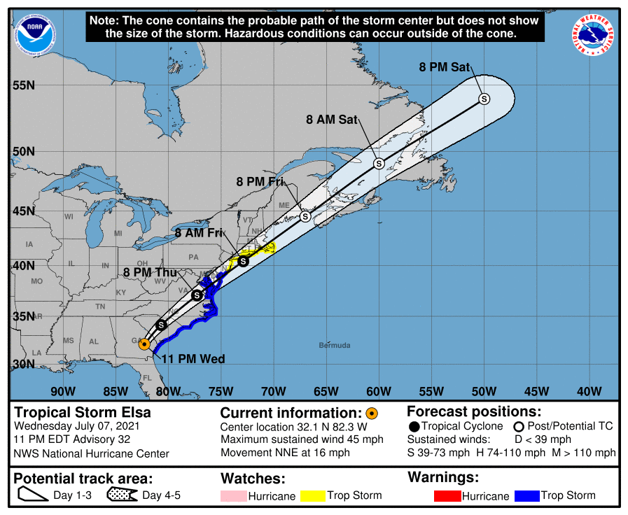
LOCATION…32.1N 82.3W
ABOUT 80 MI…125 KM NW OF BRUNSWICK GEORGIA
ABOUT 150 MI…240 KM WSW OF CHARLESTON SOUTH CAROLINA
MAXIMUM SUSTAINED WINDS…45 MPH…75 KM/H
PRESENT MOVEMENT…NNE OR 25 DEGREES AT 16 MPH…26 KM/H
MINIMUM CENTRAL PRESSURE…1006 MB…29.71 INCHES
WATCHES AND WARNINGS
A Tropical Storm Warning is in effect for…
* Little River Inlet, South Carolina to Great Egg Inlet, New Jersey.
* Pamlico and Albemarle Sounds
* Chesapeake Bay south of North Beach and the tidal Potomac south of Cobb Island
* Delaware Bay south of Slaughter Beach
A Tropical Storm Watch is in effect for…
* North of Great Egg Inlet, New Jersey to Sandy Hook, New Jersey
* Long Island from East Rockaway Inlet to the eastern tip along the south shore and from Port Jefferson Harbor eastward on the north shore
* New Haven, Connecticut to Sagamore Beach, Massachusetts including Cape Cod, Block Island, Martha’s Vineyard, and Nantucket.
DISCUSSION AND OUTLOOK
Doppler radar and surface observations indicate that Elsa is maintaining its intensity. However, these winds aren’t close to the center but, rather, in a strong band of convection in the eastern semicircle of the storm. The current wind speed is set to 40 kt in accordance with an earlier sustained wind report of 38 kt, and radar velocities reduced to the surface that would support at least 40 kt.
Some weakening is expected overnight while a significant portion of Elsa’s circulation remains over land. However by late Thursday, more of the storm will be moving over water, and a fair number of the models suggest re-intensification could take place. It is a little puzzling why the ECMWF and UKMET models, however, are showing a strengthening tropical storm close to the mid-Atlantic states, especially without a significant trough interaction or warm waters. I’m getting some deja vu in this case after working Claudette from a few weeks ago, with those same models also over-intensifying that storm. The GFS has been relatively consistent in showing only a small intensification of Elsa, and the NHC forecast will continue to be closer to that model’s relatively weaker solution.
The storm has turned north-northeastward tonight and is moving a little faster, about 14 kt. Elsa should move northeastward at an increasing forward speed during the next few days as it becomes embedded within fast southwesterly flow ahead of a mid-latitude trough. No significant changes were made to the previous track forecast since guidance remains in good agreement. Elsa is likely to become absorbed north of Newfoundland by another extratropical low by day 4.
There is greater confidence tonight that some portion of North Carolina and the mid-Atlantic coast will receive tropical-storm force-winds, so the Tropical Storm Watch has been upgraded to a Tropical Storm Warning in those areas. Areas to the north remain less certain, and remain under a Tropical Storm Watch.
KEY MESSAGES
1. As Elsa moves across southeastern Georgia into the Lowcountry of South Carolina tonight, heavy rainfall may result in considerable flash, urban, and minor river flooding. Heavy rainfall, from North Carolina across the mid-Atlantic and into New England Thursday and Friday, could lead to isolated flash and urban flooding.
2. Tropical storm conditions are expected along portions of the coasts of Georgia and South Carolina tonight. Tropical storm conditions are also expected along the coasts of North Carolina on Thursday and the mid-Atlantic by Thursday night. Tropical storm conditions are possible in the southern New England states and New York by Friday.
All images, forecasts, and documents are courtesy of their respective publishers.
Category: ALL POSTS, Severe Weather, Tropical
About the Author (Author Profile)
Scott Martin is an operational meteorologist, professional graphic artist, musician, husband, and father. Not only is Scott a member of the National Weather Association, but he is also the Central Alabama Chapter of the NWA president. Scott is also the co-founder of Racecast Weather, which provides forecasts for many racing series across the USA. He also supplies forecasts for the BassMaster Elite Series events including the BassMaster Classic.Subscribe
If you enjoyed this article, subscribe to receive more just like it.


