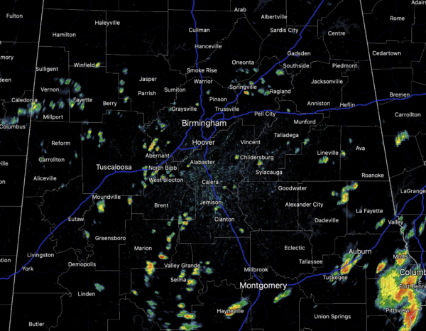
Midday Nowcast: Radar Starting to Get Active
WET WEDNESDAY WEATHER: Another day with widespread and numerous showers and storms in the forecast, especially as we head through the afternoon and evening hours, and these continue to cause localized areas of flash flooding. Also, some stronger storms are producing a lot of lightning. With the clouds and rain, temperatures will continue to hold in the 70s and 80s.
RADAR CHECK: At just before noon, like clockwork, showers and storms are beginning to develop across the Alabama landscape as daytime heating increases instability. At the writing of this forecast, the showers are scattered, but they will continue to develop and become more numerous through the afternoon. Again, expect more tropical downpours, and as storms develop, gusty winds, and lightning.
THURSDAY/FRIDAY: The upper trough begins to lifts out of the area later tonight, but with tropical air remaining in place, scattered to perhaps numerous showers and storms will remain in the forecast these two days, but the coverage should be a bit lower. Expect partly sunny days with highs in the mid to upper 80s, which remain below average for July in Alabama.
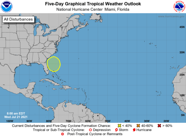
IN THE TROPICS: The Atlantic basin will remain quiet through tomorrow. However, a broad trough of low pressure associated with a decaying frontal boundary is forecast to move offshore of the southeastern United States coastline by late this week. Environmental conditions are forecast to be marginally conducive for some gradual development over the weekend into early next week while the system meanders offshore of the coasts of South Carolina, Georgia, and northeastern Florida. Formation chance through 5 days…low…20 percent.
BEACH FORECAST CENTER: Get the latest weather and rip current forecasts for the beaches from Fort Morgan to Panama City on our Beach Forecast Center page. There, you can select the forecast of the region that you are interested in visiting.
WORLD TEMPERATURE EXTREMES: Over the last 24 hours, the highest observation outside the U.S. was 123.6F at Mitribha, Kuwait. The lowest observation was -99.4F at Concordia, Antarctica.
CONTIGUOUS TEMPERATURE EXTREMES: Over the last 24 hours, the highest observation was 119F at Death Valley, CA. The lowest observation was 35F at Bodie State Parks, CA.
Category: Alabama's Weather, ALL POSTS
About the Author (Author Profile)
Macon, Georgia Television Chief Meteorologist, Birmingham native, and long time Contributor on AlabamaWX. Stormchaser. I did not choose Weather, it chose Me. College Football Fanatic. @Ryan_StinnetSubscribe
If you enjoyed this article, subscribe to receive more just like it.


