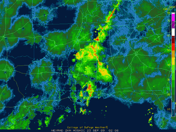
Mid-Evening in Alabama
No, the big green, round things are not huge parasols erected by FEMA to shield southeastern cities from the rain. Although it may come to that.

Those are the AP (analogous propagation) returns (false echoes) from the radar stations as the nighttime inversion sets up.
The good news: the end may be in sight…but still some short term problems.
A disturbance moving to the northeast is crossing the Mississippi River from Louisiana tonight. It has spread a huge rain shield into western Alabama.
Rain is plentiful tonight over the eastern half of Mississippi, with showers and storms spreading north northwest over parts of West Central Alabama.
The NWS has extended the area of Flash Flood Watch back into Fayette, Greene, Hale, Lamar, Marion, Pickens, Tuscaloosa, Walker and Winston Counties until 6 a.m. The Flash Flood Watch continues for Marengo and Sumter Counties until 6 a.m. CDT.
A Flash Flood Warning is in effect until 915 p.m. CDT for Sumter County. The heaviest rain is now north of the Flash Flood Warning area, to the east of Livingston.
Lots of rain and lightning in northern Greene heading into Pickens County. The showers and storms curve over into Perry County, where a rogue cell was moving a little more north than north northwest. It is gusting out, but could bring heavy rain to western Bibb County. Can’t rule out that it could get into western Jefferson. Hopefully it will weaken.
Rainfall rates are in the 0.5-1 inch per hour range generally, with some 1.5-2.5 inch rates over eastern Sumter.
Lighter rains will reach the Tuscaloosa area before 9:30.
The Bermuda High is coming to our rescue. The high pressure is edging into Alabama from the east. This trend should continue tomorrow and Thursday, pushing the best rain chances to the west.
There will still be a chance of showers and storms tomorrow, and with the moist airmass, local rainfall amounts could be heavy. But I think the coverage tomorrow will be more in the 40% range, which is good news.
Rain chances will still be in the 40% range on Thursday, with better chances Friday and Saturday, especially Saturday afternoon and night, when we could see a round of heavy storms.
Category: Uncategorized


