Mesoscale Discussion: Severe T-Storm Watch Unlikely as Threat Should Remain Low
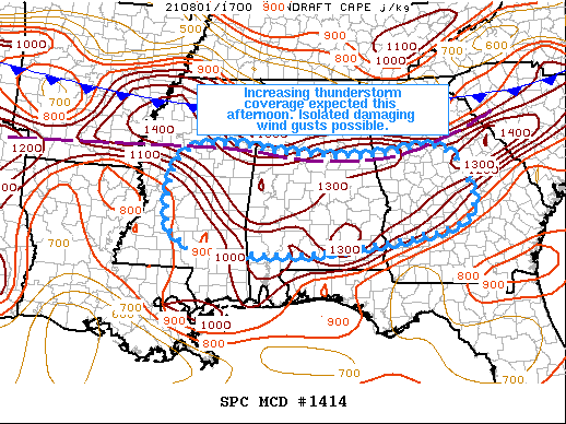
Increasing thunderstorm coverage is expected this afternoon. A few storms may become strong enough to produce damaging wind gusts.
Recent surface analysis reveals an outflow boundary extending southern Arkansas eastward across central Mississippi, Alabama, and Georgia. This outflow boundary precedes the more baroclinic cold front to its north. Visible satellite imagery shows increasingly deep cumulus across much of the region ahead of the outflow boundary, with the deepest cumulus currently in the vicinity of the small thunderstorm cluster moving across east-central Mississippi. Air mass downstream south of the outflow boundary is characterized by temperatures in the upper 80s/low 90s, dewpoints in the mid 70s, and MLCAPE generally around 2000-2500 J/kg.
Expectation is for scattered thunderstorm development across the region this afternoon. This area will be displaced south of the stronger flow aloft, but ample moisture coupled with strong buoyancy will promote strong updrafts capable of producing wet microbursts. Overall threat is expected to remain low enough to preclude watch issuance.
Category: Alabama's Weather, ALL POSTS, Severe Weather
About the Author (Author Profile)
Scott Martin is an operational meteorologist, professional graphic artist, musician, husband, and father. Not only is Scott a member of the National Weather Association, but he is also the Central Alabama Chapter of the NWA president. Scott is also the co-founder of Racecast Weather, which provides forecasts for many racing series across the USA. He also supplies forecasts for the BassMaster Elite Series events including the BassMaster Classic.Subscribe
If you enjoyed this article, subscribe to receive more just like it.


