Midday Nowcast: Sun for Some, Clouds for Others
Not too bad for August in Alabama outside today with relatively dry air in place, especially over the northern half of the state. We are seeing plenty of sunshine across West Alabama, while more clouds are showing up over East Alabama, temperatures this afternoon are climbing into the upper 80s to low 90s across the state.
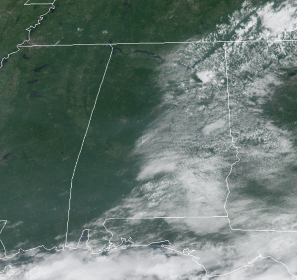
Showers and storms if any, will be few and far between, as the better rain chances are down across Far South Alabama and along the Gulf Coast. Tonight will be another clear and comfortable one with widespread soothing 60s area wide. For tomorrow and Friday, not much change in the weather as the days will feature temperatures near 90°, more sun than clouds, and some pop-up showers and storms. Late Friday, we will begin to increase rain chances some across the state.
THE ALABAMA WEEKEND: Nothing unusual for August in Alabama this weekend. Both Saturday and Sunday will feature a mix of sun and clouds with scattered to perhaps numerous showers and storms, no “washout” by any means. Highs over the weekend will be around 90 degrees.
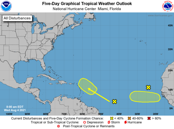
IN THE TROPICS: Most of the Atlantic is quiet, but we continue to watch the far eastern Atlantic…A tropical wave is forecast to move off the west coast of Africa by late Thursday. Environmental conditions appear somewhat conducive for some slow development over the far eastern Atlantic through the weekend into early next week while the system moves generally westward at about 15 mph. Formation chance through 5 days…low…30 percent.
A tropical wave located over the central tropical Atlantic is producing a broad area of disorganized showers and thunderstorms. Environmental conditions are expected to be marginally conducive for some slow development east of the Lesser Antilles by Sunday and into early next week while the disturbance moves west-northwestward at 10 to 15 mph. Formation chance through 5 days…low…20 percent.
BEACH FORECAST CENTER: Get the latest weather and rip current forecasts for the beaches from Fort Morgan to Panama City on our Beach Forecast Center page. There, you can select the forecast of the region that you are interested in visiting.
WORLD TEMPERATURE EXTREMES: Over the last 24 hours, the highest observation outside the U.S. was 125.2F at Colinas Do Tocantins, Brazil. The lowest observation was -99.0F at University Dome, Antarctica.
CONTIGUOUS TEMPERATURE EXTREMES: Over the last 24 hours, the highest observation was 122F at Death Valley, CA. The lowest observation was 35F at Mackay, ID.
WEATHER ON THIS DATE IN 1882: A vivid aurora was visible from Oregon to Maine, down the east coast as far as Mayport FL, and inland as far as Wellington KS. Observers at Louisville KY noted merry dancers across the sky, and observers at Saint Vincent, MN, noted it was probably the most brilliant ever seen at that location.
Category: Alabama's Weather, ALL POSTS
About the Author (Author Profile)
Macon, Georgia Television Chief Meteorologist, Birmingham native, and long time Contributor on AlabamaWX. Stormchaser. I did not choose Weather, it chose Me. College Football Fanatic. @Ryan_StinnetSubscribe
If you enjoyed this article, subscribe to receive more just like it.


