Midday Nowcast: Plenty of Sunshine
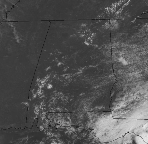
It is a generally sunny and dry day across North/Central Alabama as the lower humidity levels persist. Afternoon showers will remain few and far between today as rain chances are around 20%. Temperatures again this afternoon will be ranging from the upper 80s to lower 90s. Tonight will be another comfortable one as lows slide into the 60s and low 70s.
FRIDAY AND THE WEEKEND: A weak upper trough will be working across the region tomorrow and Saturday which will bring better rain chances both days as scattered showers and storms will be more common across the Alabama landscape, but still many locations will remain dry. Rain chances both days will be in the 30-40% range. Expect a mix of sun and clouds with highs in the upper 80s. By Sunday, the trough lifts out of the area and an upper ridge will begin to build in, causing rain chances to fall to less than 20% again. Highs Sunday should be in the lower 90s.
TROPICS ARE WAKING UP: Two areas we are watching that could develop and the next two names on the list are Fred and Grace.
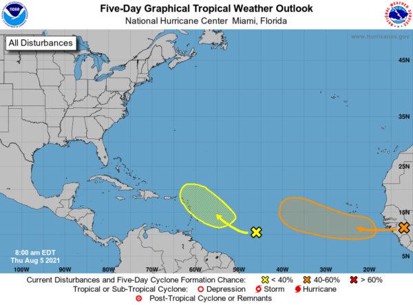
1. A westward-moving tropical wave just inland over Africa is producing a large area of disorganized showers and thunderstorms. The wave is expected to move off of the west African coast later today. Environmental conditions appear somewhat conducive for gradual development, and a tropical depression could form over the eastern tropical Atlantic by late Sunday or early next week while the system moves westward to west-northwestward at about 15 mph. Formation chance through 5 days…medium…60 percent.
2. A tropical wave located over the central tropical Atlantic continues to produce a broad area of disorganized showers and thunderstorms. Environmental conditions are expected to be marginally conducive for some slow development east of the Lesser Antilles by early next week while the disturbance moves west-northwestward at 10 to 15 mph. Formation chance through 5 days…low…20 percent.
BEACH FORECAST CENTER: Get the latest weather and rip current forecasts for the beaches from Fort Morgan to Panama City on our Beach Forecast Center page. There, you can select the forecast of the region that you are interested in visiting.
WORLD TEMPERATURE EXTREMES: Over the last 24 hours, the highest observation outside the U.S. was 122.9F at Jahra, Kuwait. The lowest observation was -97.8F at Nico, Antarctica.
CONTIGUOUS TEMPERATURE EXTREMES: Over the last 24 hours, the highest observation was 126F at Death Valley, CA. The lowest observation was 33F at Peter Sinks, UT.
WEATHER ON THIS DATE IN 1843: A spectacular cloudburst near Philadelphia turned the small creeks and streams entering the Delaware River into raging torrents. As much as sixteen inches of rain fell in just three hours. Flooding destroyed thirty-two county bridges, and caused nineteen deaths. It is believed that several small tornadoes accompanied the torrential rains, one of which upset and sank more than thirty barges on the Schuylkill River.
Category: Alabama's Weather, ALL POSTS
About the Author (Author Profile)
Macon, Georgia Television Chief Meteorologist, Birmingham native, and long time Contributor on AlabamaWX. Stormchaser. I did not choose Weather, it chose Me. College Football Fanatic. @Ryan_StinnetSubscribe
If you enjoyed this article, subscribe to receive more just like it.


