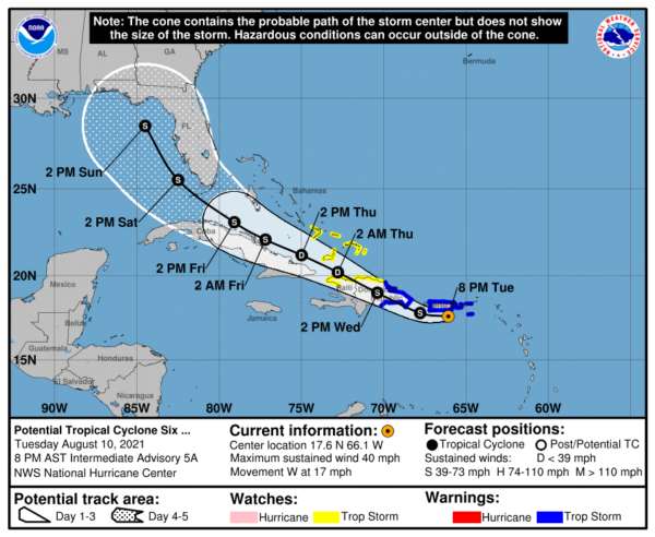
7 pm Advisory: PTC-6 Located Just South of Puerto Rico, Likely to Become Tropical Storm Fred Tonight
SUMMARY OF 700 PM CDT…0000 UTC…INFORMATION
LOCATION…17.6N 66.1W
ABOUT 40 MI…60 KM SE OF PONCE PUERTO RICO
ABOUT 240 MI…390 KM ESE OF SANTO DOMINGO DOMINICAN REPUBLIC
MAXIMUM SUSTAINED WINDS…40 MPH…65 KM/H
PRESENT MOVEMENT…WNW OR 270 DEGREES AT 17 MPH…28 KM/H
MINIMUM CENTRAL PRESSURE…1009 MB…29.80 INCHES
WATCHES AND WARNINGS
A Tropical Storm Warning is in effect for…
* Puerto Rico, including Culebra and Vieques
* U.S. Virgin Islands
* Dominican Republic on the south coast from Punta Palenque eastward and on the north coast from Cabo Frances Viejo eastward
A Tropical Storm Watch is in effect for…
* Dominican Republic on the north coast from Cabo Frances Viejo to the Dominican Republic/Haiti border
* Haiti from the northern border with the Dominican Republic to Gonaives
* Turks and Caicos Islands
* Southeastern Bahamas
DISCUSSION AND OUTLOOK
At 800 PM AST (0000 UTC), the disturbance was located by an Air Force Reserve reconnaissance aircraft and Doppler radar data from San Juan near latitude 17.6 North, longitude 66.1 West. The system is moving toward the west near 17 mph (28 km/h) and this general motion is expected to continue tonight. A turn back toward the west-northwest is forecast to occur early Wednesday, with a west-northwestward motion continuing during the next few days. On the forecast track, the disturbance is expected to pass near the southern coast of Puerto Rico tonight and early Wednesday, be near or over Hispaniola on Wednesday, and be near the southeastern Bahamas and the Turks and Caicos Islands on Thursday.
Data from the aircraft and surface observations indicate that maximum sustained winds have increased to near 40 mph (65 km/h) with higher gusts. Gradual strengthening is forecast during the next day or so and the disturbance is expected to become a tropical storm later tonight. Some weakening is likely while the system interacts with Hispaniola on Wednesday.
* Formation chance through 48 hours…high…90 percent.
* Formation chance through 5 days…high…90 percent.
The estimated minimum central pressure based on data from the aircraft and earlier surface observations is 1009 mb (29.80 inches).
Tropical-storm-force winds extend outward up to 40 miles (65 km), mainly northeast of the center. During the past few hours, a sustained wind of 38 mph (61 km/h) and a gust to 49 mph (79 km/h) were measured by a Weatherflow observing station at Sandy Point on the western end of St. Croix. A wind gust to 47 mph (76 km/h) was reported near Yabucoa in southeastern Puerto Rico.
HAZARDS AFFECTING LAND
RAINFALL: The system is expected to produce the following rainfall amounts:
Over the Leeward Islands, Virgin Islands, Puerto Rico, and the Dominican Republic…2 to 4 inches, with isolated maximum totals of 6 inches. Heavy rainfall could lead to flash, urban, and small stream flooding, along with possible rapid river rises and the potential for mudslides across the U.S. Virgin Islands, Puerto Rico, and the Dominican Republic.
Over Haiti, the Turks and Caicos, eastern Bahamas, and eastern Cuba…1 to 3 inches with isolated maximum totals of 5 inches.
WIND: Tropical storm conditions are expected in the warning areas in the U.S. Virgin Islands and Puerto Rico during the next several hours, and in the warning area in the Dominican Republic by early Wednesday. Tropical storm conditions are possible elsewhere along the northern coasts of the Dominican Republic, northern Haiti, the Turks and Caicos, and the southeastern Bahamas beginning late Wednesday.
SURF: Swells generated by the disturbance are affecting portions of the Leeward Islands. These swells are expected to spread across the U.S. Virgin Islands and Puerto Rico today and reach portions of Hispaniola on Wednesday, where they could cause life-threatening surf and rip current conditions.


