We Have Fred
Air Force reconnaissance found a definite center finally and we now have Tropical Storm Fred south of Puerto Rico.
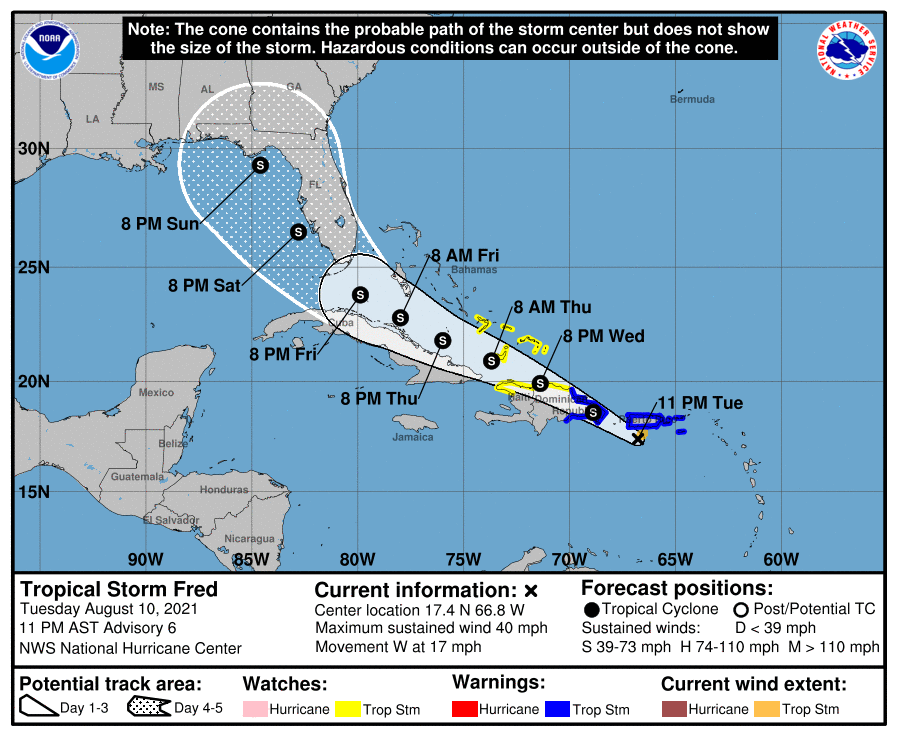
The official track carries it over the Dominican Republic and back over the water south of the Bahamas. It moves into the southeastern Gulf of Mexico early Saturday morning. The track brings the center near the coast of the Florida Panhandle near Apalachicola Sunday night as a tropical storm.
Lots of uncertainty in the track and intensity forecast. The 2-3 days will help us get a much better handle on the track and eventual intensity.
Here is the complete text of the advisory:
BULLETIN
Tropical Storm Fred Advisory Number 6
NWS National Hurricane Center Miami FL AL062021
1100 PM AST Tue Aug 10 2021
…TROPICAL STORM FRED DEVELOPS JUST SOUTH OF PUERTO RICO…
…HEAVY RAINS AND GUSTY WINDS SPREADING ACROSS PUERTO RICO
OVERNIGHT AND OVER HISPANIOLA ON WEDNESDAY…
SUMMARY OF 1100 PM AST…0300 UTC…INFORMATION
———————————————–
LOCATION…17.4N 66.8W
ABOUT 45 MI…70 KM SSW OF PONCE PUERTO RICO
ABOUT 215 MI…350 KM ESE OF SANTO DOMINGO DOMINICAN REPUBLIC
MAXIMUM SUSTAINED WINDS…40 MPH…65 KM/H
PRESENT MOVEMENT…W OR 270 DEGREES AT 17 MPH…28 KM/H
MINIMUM CENTRAL PRESSURE…1009 MB…29.80 INCHES
WATCHES AND WARNINGS
——————–
CHANGES WITH THIS ADVISORY:
None.
SUMMARY OF WATCHES AND WARNINGS IN EFFECT:
A Tropical Storm Warning is in effect for…
* Puerto Rico, including Culebra and Vieques
* U.S. Virgin Islands
* Dominican Republic on the south coast from Punta Palenque
eastward and on the north coast from Cabo Frances Viejo eastward
A Tropical Storm Watch is in effect for…
* Dominican Republic on the north coast from Cabo Frances Viejo to
the Dominican Republic/Haiti border
* Haiti from the northern border with the Dominican Republic to
Gonaives
* Turks and Caicos Islands
* Southeastern Bahamas
A Tropical Storm Warning means that tropical storm conditions are
expected somewhere within the warning area, in this case within the
next 12 hours.
A Tropical Storm Watch means that tropical storm conditions are
possible within the watch area.
Interests elsewhere in Haiti and the Bahamas, as well as in eastern
and central Cuba, should monitor the progress of this system.
For storm information specific to your area in the United States,
including possible inland watches and warnings, please monitor
products issued by your local National Weather Service forecast
office. For storm information specific to your area outside of the
United States, please monitor products issued by your national
meteorological service.
DISCUSSION AND OUTLOOK
———————-
At 1100 PM AST (0300 UTC), the center of Tropical Storm Fred was
located by the San Juan NOAA Doppler weather radar near latitude
17.4 North, longitude 66.8 West. Fred is moving toward the west near
17 mph (28 km/h) and this general motion is expected to continue
tonight. A turn back toward the west-northwest is forecast to occur
early Wednesday, with a west-northwestward motion continuing during
the next few days. On the forecast track, Fred is expected to pass
near the southern coast of Puerto Rico tonight and early Wednesday,
be near or over Hispaniola on Wednesday, and be near the
southeastern Bahamas and the Turks and Caicos Islands on Thursday.
Maximum sustained winds are near 40 mph (65 km/h) with higher gusts.
Slight strengthening is forecast overnight before Fred reaches
eastern Dominican Republic Wednesday morning. Some weakening is
likely while the system interacts with Hispaniola on Wednesday.
Tropical-storm-force winds extend outward up to 45 miles (75 km)
from the center. A wind gust to 41 mph (66 km/h) was recently
measured by a Weatherflow observing site in Las Mareas along the
south-central coast of Puerto Rico.
The estimated minimum central pressure is 1009 mb (29.80 inches).
HAZARDS AFFECTING LAND
———————-
Key messages for Tropical Storm Fred can be found in the Tropical
Cyclone Discussion under AWIPS header MIATCDAT1, WMO header
WTNT41 KNHC and on the web at
www.hurricanes.gov/graphics_at1.shtml?key_messages.
RAINFALL: Fred is expected to produce the following rainfall
amounts:
Over the Leeward Islands, Virgin Islands, Puerto Rico, and the
Dominican Republic…2 to 4 inches, with isolated maximum totals
of 6 inches. Heavy rainfall could lead to flash, urban, and small
stream flooding, along with possible rapid river rises and the
potential for mudslides across the U.S. Virgin Islands, Puerto Rico,
and the Dominican Republic.
Over Haiti, the Turks and Caicos, eastern Bahamas, and eastern
Cuba…1 to 3 inches with isolated maximum totals of 5 inches.
WIND: Tropical storm conditions are expected in the warning areas
in the U.S. Virgin Islands and Puerto Rico during the next several
hours, and in the warning area in the Dominican Republic by early
Wednesday. Tropical storm conditions are possible elsewhere along
the northern coasts of the Dominican Republic, northern Haiti, the
Turks and Caicos, and the southeastern Bahamas beginning late
Wednesday.
SURF: Swells generated by Tropical Storm Fred are affecting
portions of the Leeward Islands. These swells are expected to
spread across the U.S. Virgin Islands and Puerto Rico today and
reach portions of Hispaniola on Wednesday, where they could cause
life-threatening surf and rip current conditions. Please consult
products from your local weather office.
NEXT ADVISORY
————-
Next intermediate advisory at 200 AM AST.
Next complete advisory at 500 AM AST.
$$
Forecaster Stewart
Category: Alabama's Weather, ALL POSTS, Tropical
About the Author (Author Profile)
Bill Murray is the President of The Weather Factory. He is the site's official weather historian and a weekend forecaster. He also anchors the site's severe weather coverage. Bill Murray is the proud holder of National Weather Association Digital Seal #0001 @wxhistorianSubscribe
If you enjoyed this article, subscribe to receive more just like it.


