7 pm Advisories — Fred Remains Unorganized for Now, TD-7 Soon to be Tropical Storm Grace
Tropical Depression Fred
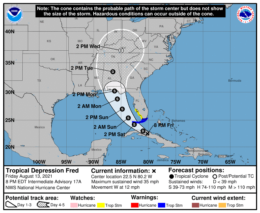
Info as of 7 pm CDT
LOCATION…22.5N 80.2W
ABOUT 45 MI…70 KM W OF CAIBARIEN CUBA
ABOUT 175 MI…285 KM SE OF KEY WEST FLORIDA
MAXIMUM SUSTAINED WINDS…35 MPH…55 KM/H
PRESENT MOVEMENT…W OR 280 DEGREES AT 12 MPH…19 KM/H
MINIMUM CENTRAL PRESSURE…1013 MB…29.92 INCHES
Watches & Warnings
A Tropical Storm Warning is in effect from the Florida Keys west of Ocean Reef to the Dry Tortugas and for Florida Bay.
A Tropical Storm Watch is in effect from the southwest coast of Florida from Englewood south and east to Ocean Reef.
Discussion & Outlook
Fred is expected to begin a west-northwestward motion overnight, then turning toward the northwest on Saturday, with this general motion continuing through early Monday. On the forecast track,
Fred is expected to continue moving near the north coast of central Cuba tonight, pass near or west of the lower Florida Keys on Saturday, and pass near or west of the west coast of the Florida peninsula Saturday night and Sunday. Little change in strength is expected tonight. After that,
slow strengthening is forecast, and Fred could become a tropical storm again on Saturday.
Hazards Affecting Land
RAINFALL: Fred is expected to produce the following rainfall amounts:
• Portions of Cuba…2 to 5 inches with isolated maximum totals of 8 inches. This rainfall may lead to scattered flash flooding.
• Across the Bahamas…1 to 3 inches, with isolated maximum totals of 5 inches.
• Today through Monday, 3 to 6 inches of rain is anticipated across the Keys, southern and central Florida north towards the Big Bend, with isolated maximum totals of 8 inches. Heavy rainfall could lead to areal, urban, and small stream flooding, and potentially worsen ongoing minor to isolated moderate river flooding over northern Florida.
• From Sunday onward, heavy rain and flood impacts could extend into inland portions of the Southeast and into the southern and central Appalachians and Piedmont as Fred interacts with a front in the area.
WIND: Tropical storm conditions are expected in portions of the warning area across the Florida Keys on Saturday. Tropical storm conditions are possible in the watch area in Florida beginning Saturday.
SURF: Swells generated by Fred are expected to spread across portions of the Bahamas and the northern coast of Cuba through tonight. These swells could reach the Florida Keys and southern Florida by early Saturday and increase along the west coast of Florida Saturday night and Sunday.
TORNADOES: There will be a risk of isolated tornadoes beginning Saturday afternoon over parts of central and south Florida.
Tropical Depression Seven
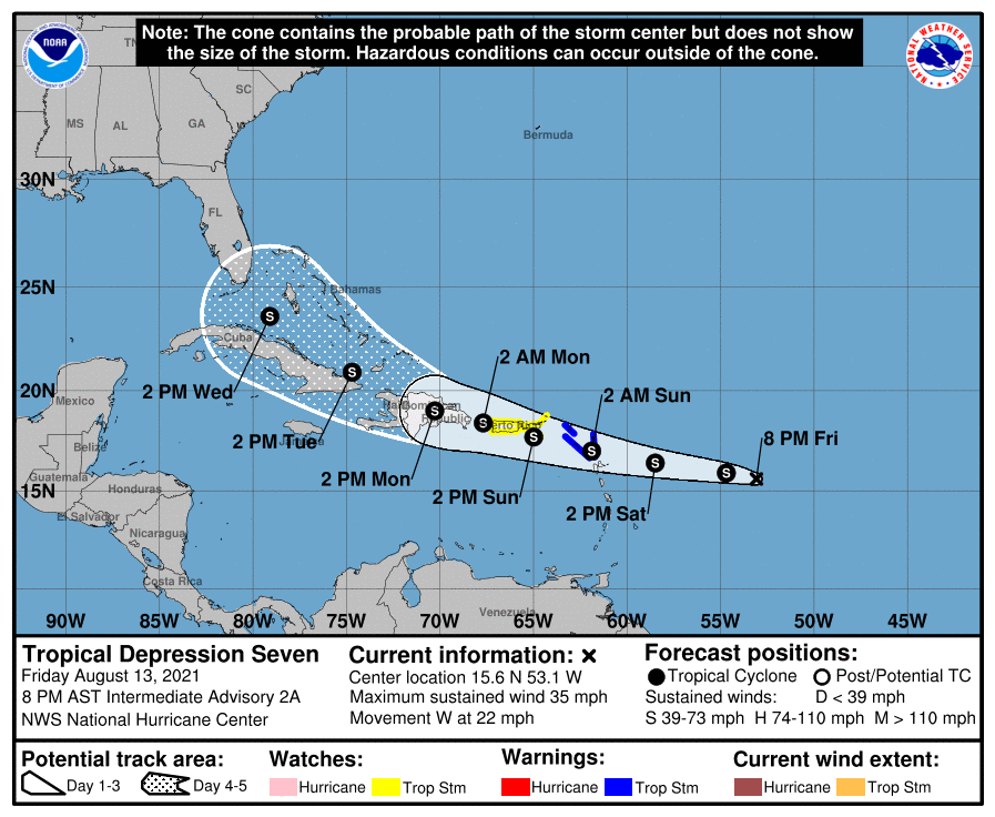
Info as of 7 pm CDT
LOCATION…15.6N 53.1W
ABOUT 580 MI…935 KM E OF THE LEEWARD ISLANDS
MAXIMUM SUSTAINED WINDS…35 MPH…55 KM/H
PRESENT MOVEMENT…W OR 275 DEGREES AT 22 MPH…35 KM/H
MINIMUM CENTRAL PRESSURE…1010 MB…29.83 INCHES
Watches & Warnings
A Tropical Storm Warning is in effect for…
* Antigua and Barbuda, Anguilla, St. Kitts and Nevis, and Montserrat
* Saba and Sint Eustatius
* Sint Maarten
* St. Martin and St. Barthelemy
A Tropical Storm Watch is in effect for…
* British Virgin Islands
* U.S. Virgin Islands
* Puerto Rico, including Vieques and Culebra
Discussion & Outlook
A motion toward the west or west-northwest with a gradual decrease in forward speed is expected during the next few days. On the forecast track, the center of the depression is forecast to move over the Leeward Islands Saturday night, over the Virgin Islands and Puerto Rico on Sunday, and then over the Dominican Republic on Monday. Some strengthening is forecast during the next couple of days, and the depression is expected to become a tropical storm tonight or on Saturday.
Hazards Affecting Land
WIND: Tropical storm conditions are expected within the warning area over the Leeward Islands by Saturday night or early Sunday. Tropical storm conditions are possible over the Virgin Islands and Puerto Rico beginning on Sunday.
RAINFALL: The depression is expected to produce the following rainfall amounts Saturday into Monday:
• Over the northern Leeward Islands and Virgin Islands…3 to 6 inches. This rainfall may produce scattered areas of flash and urban flooding.
• Over Puerto Rico…3 to 6 inches. Heavy rainfall could lead to flash, urban, and small stream flooding as well as potential mudslides.
Category: Alabama's Weather, ALL POSTS, Severe Weather, Tropical
About the Author (Author Profile)
Scott Martin is an operational meteorologist, professional graphic artist, musician, husband, and father. Not only is Scott a member of the National Weather Association, but he is also the Central Alabama Chapter of the NWA president. Scott is also the co-founder of Racecast Weather, which provides forecasts for many racing series across the USA. He also supplies forecasts for the BassMaster Elite Series events including the BassMaster Classic.Subscribe
If you enjoyed this article, subscribe to receive more just like it.


