10 pm Advisory — Heavy Rains Continue Over Central Cuba from TD Fred
SUMMARY OF 10:00 PM CDT INFORMATION
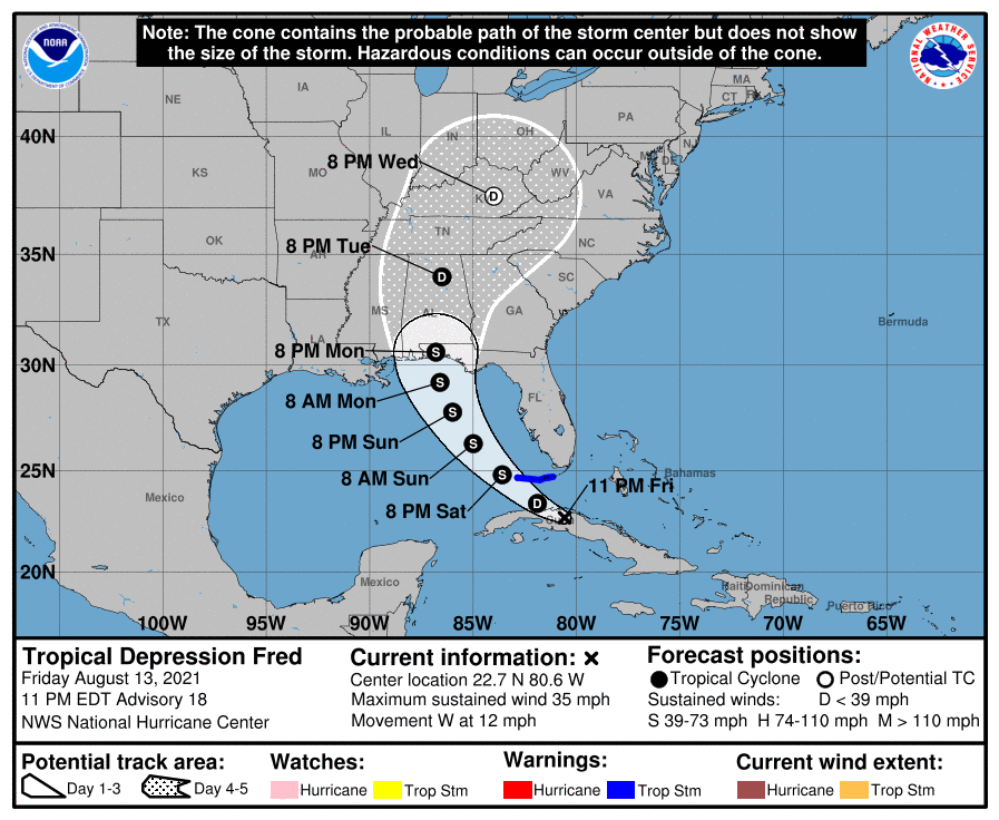
LOCATION…22.7N 80.6W
ABOUT 45 MI…75 KM SE OF VARADERO CUBA
ABOUT 150 MI…245 KM SSE OF KEY WEST FLORIDA
MAXIMUM SUSTAINED WINDS…35 MPH…55 KM/H
PRESENT MOVEMENT…W OR 280 DEGREES AT 12 MPH…19 KM/H
MINIMUM CENTRAL PRESSURE…1013 MB…29.92 INCHES
WATCHES AND WARNINGS
A Tropical Storm Warning is in effect for…
* The Florida Keys west of the Seven Mile Bridge to the Dry Tortugas
FORECAST DISCUSSION
Interaction with land and southwesterly shear has continued to take a toll on Fred this evening. It is very difficult to determine in infrared satellite imagery and recent surface observations from Cuba if a closed circulation still exists, however the system is maintained as a tropical depression for now. Scatterometer data, which should arrive very soon, and reconnaissance aircraft observations on Saturday morning should provide additional information on the system’s intensity and structure.
The system still appears to be moving moving westward or 280/11 kt. There has been no change to the track forecast reasoning from the previous advisory. The cyclone is approaching the western periphery of a subtropical ridge extending over the western Atlantic, and Fred should turn west-northwestward overnight, and then northwestward on Saturday. The track guidance has again shifted westward, but the shift is not as large as was noted on the previous cycle. The NHC track forecast has been adjusted to the left, closer to the consensus aids, but it still remains to the east of those models. Some additional westward adjustments in subsequent forecasts may be required.
As mentioned above, land interaction and southwesterly vertical will limit any attempt of re-organization overnight, however the system is expected to move off the northern coast of Cuba Saturday morning and the global model guidance suggests that a center re-formation could occur over the western portion of the Straits of Florida. The center re-formation shown by the guidance appears to be aided by an area of upper-level diffluent flow to the southeast of an upper-level trough currently located over the eastern Gulf of Mexico. Although only a little strengthening is indicated in the official forecast through 36 hours, the environment could become a little more conducive on Sunday, and the NHC wind speed forecast again calls for gradual strengthening while Fred moves northwestward over the eastern Gulf. The updated intensity forecast is unchanged from the previous advisory and is a blend of the statistical guidance and the HCCA model. The intensity forecast continues to be of lower-than-normal confidence given the current disorganized structure of the system.
KEY MESSAGES
1. Tonight through Monday, heavy rainfall could lead to areal, urban, and small stream flooding impacts, and cause new and renewed river flooding, across southern and central Florida into the Big Bend. From Sunday onward, heavy rain and flood impacts could extend into other portions of the Southeast and into the southern and central Appalachians and Piedmont as Fred interacts with a front in the area.
2. Tropical storm conditions are expected in portions of the Lower Florida Keys on Saturday, where a Tropical Storm Warning is in effect.
3. There is a risk of tropical storm conditions in the Florida Panhandle beginning on Monday. Watches may be required for a portion of this area on Saturday.
Category: Alabama's Weather, ALL POSTS, Severe Weather, Tropical
About the Author (Author Profile)
Scott Martin is an operational meteorologist, professional graphic artist, musician, husband, and father. Not only is Scott a member of the National Weather Association, but he is also the Central Alabama Chapter of the NWA president. Scott is also the co-founder of Racecast Weather, which provides forecasts for many racing series across the USA. He also supplies forecasts for the BassMaster Elite Series events including the BassMaster Classic.Subscribe
If you enjoyed this article, subscribe to receive more just like it.


