The Latest on Tropical Depression Grace at 4 p.m.
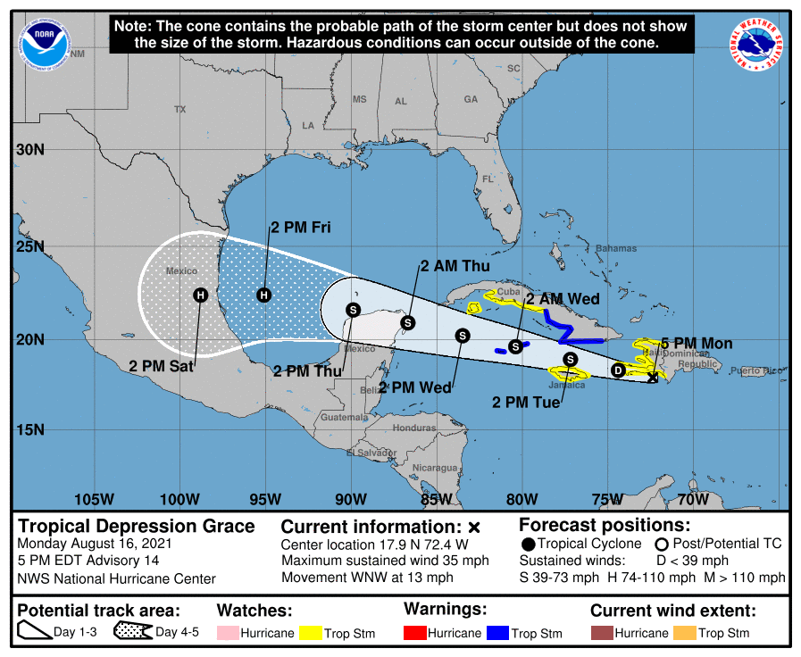
Grace has managed to mainly miss the island of Hispaniola with the center crossing over the Barahona Peninsula on the southwestern end of Dominican Republic.
It will cross the southwestern tip of Haiti. then pass between Jamaica and eastern Cuba, then pass near the Caymans around midnight tomorrow night. It is expected to be intensifying at that time and it should be near or at hurricane status by midnight Wednesday night as it grazes the northern Yucatan Channel, making landfall near Cozumel.
It is definitely expected to become a hurricane over the southwestern Gulf of Mexico before making landfall again near Tampico, Mexico. That will be about 250 or 300 miles south of Brownsville.
BULLETIN
Tropical Depression Grace Advisory Number 14
NWS National Hurricane Center Miami FL AL072021
500 PM EDT Mon Aug 16 2021
…TORRENTIAL RAINS CONTINUE OVER PORTIONS OF HAITI AND THE
DOMINICAN REPUBLIC…
…GRACE FORECAST TO STRENGTHEN OVER THE NORTHWESTERN CARIBBEAN
SEA…
SUMMARY OF 500 PM EDT…2100 UTC…INFORMATION
———————————————-
LOCATION…17.9N 72.4W
ABOUT 50 MI…80 KM S OF PORT AU PRINCE HAITI
ABOUT 365 MI…585 KM E OF MONTEGO BAY JAMAICA
MAXIMUM SUSTAINED WINDS…35 MPH…55 KM/H
PRESENT MOVEMENT…WNW OR 285 DEGREES AT 13 MPH…20 KM/H
MINIMUM CENTRAL PRESSURE…1007 MB…29.74 INCHES
WATCHES AND WARNINGS
——————–
CHANGES WITH THIS ADVISORY:
None.
SUMMARY OF WATCHES AND WARNINGS IN EFFECT:
A Tropical Storm Warning is in effect for…
* Southern coast of the Cuban provinces of Santiago de Cuba, Granma,
Las Tunas, and Camaguey
* Cayman Islands
A Tropical Storm Watch is in effect for…
* Entire coast of Haiti
* Jamaica
* Southern coast of the Cuban provinces of Ciego de Avila, Sancti
Spiritus, Cienfuegos, and Matanzas, as well as Isla de la Juventud.
A Tropical Storm Warning means that tropical storm conditions are
expected somewhere within the warning area within 36 hours.
A Tropical Storm Watch means that tropical storm conditions are
possible within the watch area, generally within 48 hours.
Interests elsewhere in Cuba and the Yucatan Peninsula of Mexico
should monitor the progress of Grace. Additional watches or
warnings are possible tonight or on Tuesday.
For storm information specific to your area, please monitor
products issued by your national meteorological service.
DISCUSSION AND OUTLOOK
———————-
At 500 PM EDT (2100 UTC), the center of Tropical Depression Grace
was located near latitude 17.9 North, longitude 72.4 West. Grace is
moving toward the west-northwest near 13 mph (20 km/h). A west to
west-northwest motion is expected during the next few days. On the
forecast track, the center of Grace will move near the Tiburon
Peninsula of Haiti through tonight, move between Jamaica and
southeastern Cuba on Tuesday, near the Cayman Islands Tuesday
night, and approach the Yucatan Peninsula of Mexico Wednesday and
Wednesday night.
Maximum sustained winds are near 35 mph (55 km/h) with higher gusts.
Strengthening is forecast during the next few days, and Grace is
expected to regain tropical storm status on Tuesday. Grace could
be near hurricane strength when it approaches the Yucatan Peninsula
of Mexico Wednesday night.
The estimated minimum central pressure is 1007 mb (29.74 inches).
HAZARDS AFFECTING LAND
———————-
Key messages for Grace can be found in the Tropical Cyclone
Discussion under AWIPS header MIATCDAT2, WMO header WTNT42 KNHC
and on the web at
www.hurricanes.gov/graphics_at2.shtml?key_messages.
WIND: Tropical storm conditions are possible in Haiti this evening
into tonight, and in Jamaica on Tuesday. Tropical storm conditions
are expected along the southern coast of Cuba within the warning
area on Tuesday, and over the Cayman Islands beginning late Tuesday
into early Wednesday. Tropical storm conditions are possible along
the southern coast of Cuba within the watch area Tuesday night and
Wednesday.
RAINFALL: Grace is expected to produce the following rainfall
amounts:
Over Haiti and the Dominican Republic…5 to 10 inches of rain with
isolated maximum totals of 15 inches are expected across the
southern terrain areas through Tuesday. This heavy rainfall may lead
to flash and urban flooding, and possible mudslides.
Over far southern Cuba, Jamaica, and the Cayman Islands….2 to 4
inches of rain with isolated maximum totals of 6 inches are expected
through Thursday. This heavy rainfall may lead to flash and urban
flooding.
SURF: Swells generated by Grace will continue to affect portions of
Hispaniola over the next day or so, and will spread westward to
Jamaica, the Cayman Islands, the southern coast of Cuba, and the
Yucatan Peninsula of Mexico. These swells are likely to cause
life-threatening surf and rip current conditions. Please consult
products from your local weather office.
NEXT ADVISORY
————-
Next intermediate advisory at 800 PM EDT.
Next complete advisory at 1100 PM EDT.
$$
Forecaster Berg
Category: Alabama's Weather, ALL POSTS, Severe Weather, Tropical
About the Author (Author Profile)
Bill Murray is the President of The Weather Factory. He is the site's official weather historian and a weekend forecaster. He also anchors the site's severe weather coverage. Bill Murray is the proud holder of National Weather Association Digital Seal #0001 @wxhistorianSubscribe
If you enjoyed this article, subscribe to receive more just like it.


