The Latest on Tropical Storm Fred as of 4 p.m.
The center of Tropical Storm Fred is approaching Wilma, Florida, or about 55 miles southwest of Tallahassee this afternoon, after making landfall around 2:15 p.m. CDT as a 65 mph storm with a central pressure of 994 millibars.
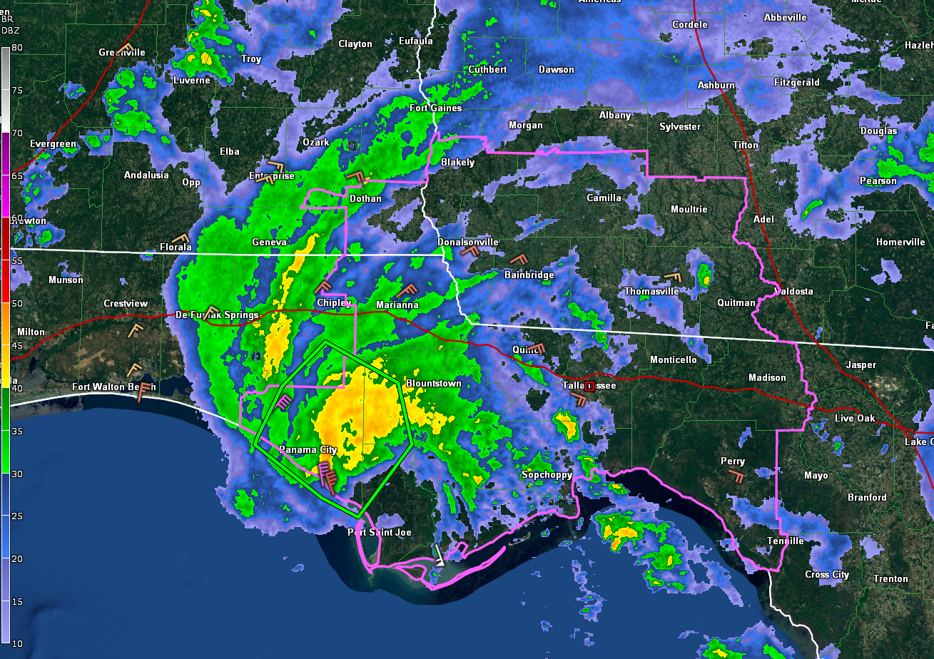
So far 1.18 inches of rain at Northwest Florida Beaches International Airport west of Panama City. 3.67 inches at Apalachicola, but the rain has ended there. The wind hasn’t: winds are currently gusting to 68 mph there. Their peak sustained wind has been 49 mph, but winds have been gusting to over 60 mph for the past hour. Over 5.99 inches of rain at Tyndall AFB, with heavy rain continuing.
A Flash Flood Warning is in effect for Bay and parts of Calhoun, Gulf, and Washington Counties.
Apalachicola measured a storm surge of 4.65 feet. Luckily, the Panhandle locations were at low tide today.
In Southeast Alabama, Dothan has rain with ENE of 14 mph gusting to 26 mph.
The center of the weakening tropical storm will skim across Houston, Henry, and Barbour Counties, grazing Eufaula before exiting into Georgia. The system should weaken below tropical storm force before leaving Alabama.
A tornado watch remains in effect for Houston County in Alabama as well as counties in Northwest Florida, and southeastern Georgia. Haven’t seen any reports of tornadoes so far.
Here is the complete text of the 4 p.m. Advisory:
BULLETIN
Tropical Storm Fred Advisory Number 29
NWS National Hurricane Center Miami FL AL062021
400 PM CDT Mon Aug 16 2021
…FRED MOVING FARTHER INLAND OVER THE EASTERN FLORIDA PANHANDLE…
…HEAVY RAIN AND STORM SURGE THREAT CONTINUES…
SUMMARY OF 400 PM CDT…2100 UTC…INFORMATION
———————————————-
LOCATION…29.9N 85.3W
ABOUT 25 MI…35 KM NW OF APALACHICOLA FLORIDA
MAXIMUM SUSTAINED WINDS…60 MPH…95 KM/H
PRESENT MOVEMENT…NNE OR 20 DEGREES AT 9 MPH…15 KM/H
MINIMUM CENTRAL PRESSURE…995 MB…29.39 INCHES
WATCHES AND WARNINGS
——————–
CHANGES WITH THIS ADVISORY:
The Tropical Storm Warning west of the Okaloosa/Walton County line
is discontinued.
SUMMARY OF WATCHES AND WARNINGS IN EFFECT:
A Storm Surge Warning is in effect for…
* Coast of Florida from Indian Pass to Yankeetown
A Tropical Storm Warning is in effect for…
* Coast of the Florida Panhandle and Big Bend from the
Okaloosa/Walton County line to the Steinhatchee River
A Storm Surge Warning means there is a danger of life-threatening
inundation from rising water moving inland from the coastline in
the indicated locations. For a depiction of areas at risk, please
see the National Weather Service Storm Surge Watch/Warning Graphic,
available at hurricanes.gov. This is a life-threatening situation.
Persons located within these areas should take all necessary
actions to protect life and property from rising water and the
potential for other dangerous conditions. Promptly follow
evacuation and other instructions from local officials.
A Tropical Storm Warning means that tropical storm conditions are
expected somewhere within the warning area.
For storm information specific to your area, including possible
inland watches and warnings, please monitor products issued by your
local National Weather Service forecast office.
DISCUSSION AND OUTLOOK
———————-
At 400 PM CDT (2100 UTC), the center of Tropical Storm Fred was
located near latitude 29.9 North, longitude 85.3 West. Fred is
moving toward the north-northeast near 9 mph (15 km/h), and this
general motion with an increase in forward speed is expected over
the next couple of days. On the forecast track, Fred will move from
western Georgia on Tuesday across the southern Appalachian
Mountains to West Virginia by Wednesday.
Maximum sustained winds are near 60 mph (95 km/h) with higher gusts.
Rapid weakening is expected, and Fred should become a tropical
depression by early Tuesday.
Tropical-storm-force winds extend outward up to 115 miles (185 km)
from the center. A sustained wind of 49 mph ( 79 km/h) with a gust
to 68 mph (109 km/h) was recently observed at the Apalachicola
Airport.
The estimated minimum central pressure is 995 mb (29.39 inches).
HAZARDS AFFECTING LAND
———————-
Key messages for Fred can be found in the Tropical Cyclone
Discussion under AWIPS header MIATCDAT1, WMO header WTNT41 KNHC and
on the web at www.hurricanes.gov/graphics_at1.shtml?key_messages.
RAINFALL:
Fred is expected to produce the following rainfall amounts:
Through Tuesday…
The Florida Big Bend and Panhandle… 4 to 8 inches of rain with
isolated maximum storm totals of 12 inches are expected.
Southeast Alabama through western and northern Georgia, and the
western Carolinas… 4 to 8 inches of rain with isolated maximum
storm totals of 10 inches are expected.
Through Wednesday…
Portions of the Mid-Atlantic States…2 to 4 inches of rain with
isolated maximum storm totals of 6 inches expected as Fred interacts
with a nearby front.
Heavy rainfall across portions of the Southeast and Mid-Atlantic
States could lead to flash, urban, small stream and isolated river
flooding impacts. An increased risk of landslides exists across the
mountains of North Carolina as well as portions of the Blue Ridge
Escarpment on Tuesday.
STORM SURGE: The combination of a dangerous storm surge and the
tide will cause normally dry areas near the coast to be flooded by
rising waters moving inland from the shoreline. The water could
reach the following heights above ground somewhere in the indicated
areas if the peak surge occurs at the time of high tide…
Indian Pass to Steinhatchee River…3-5 ft
Steinhatchee River to Yankeetown, FL…2-4 ft
Okaloosa/Walton County Line, FL to Indian Pass including
Choctawhatchee Bay and Saint Andrew Bay… 1-3 ft
Yankeetown, FL to Aripeka, FL…1-3 ft
The deepest water will occur along the immediate coast near and to
the east of the landfall location, where the surge will be
accompanied by large waves. Surge-related flooding depends on the
relative timing of the surge and the tidal cycle, and can vary
greatly over short distances. For information specific to your
area, please see products issued by your local National Weather
Service forecast office.
WIND: Tropical storm conditions will continue in portions of the
Tropical Storm warning area for the next few hours.
SURF: Swells generated by Fred are affecting the coasts of
Mississippi, Alabama and the Florida Panhandle, and could
causing life-threatening surf and rip current conditions. Please
consult products from your local weather office for more details.
TORNADOES: A few tornadoes are possible this evening and tonight
across parts of the Florida Panhandle, southwest Georgia, and
southeast Alabama. The tornado threat will shift northward into
parts of northeast Georgia, the western Carolinas, and southern
Virginia on Tuesday.
NEXT ADVISORY
————-
Next intermediate advisory at 700 PM CDT.
Next complete advisory at 1000 PM CDT.
$$
Forecaster Pasch
Category: Alabama's Weather, ALL POSTS, Severe Weather, Tropical
About the Author (Author Profile)
Bill Murray is the President of The Weather Factory. He is the site's official weather historian and a weekend forecaster. He also anchors the site's severe weather coverage. Bill Murray is the proud holder of National Weather Association Digital Seal #0001 @wxhistorianSubscribe
If you enjoyed this article, subscribe to receive more just like it.


