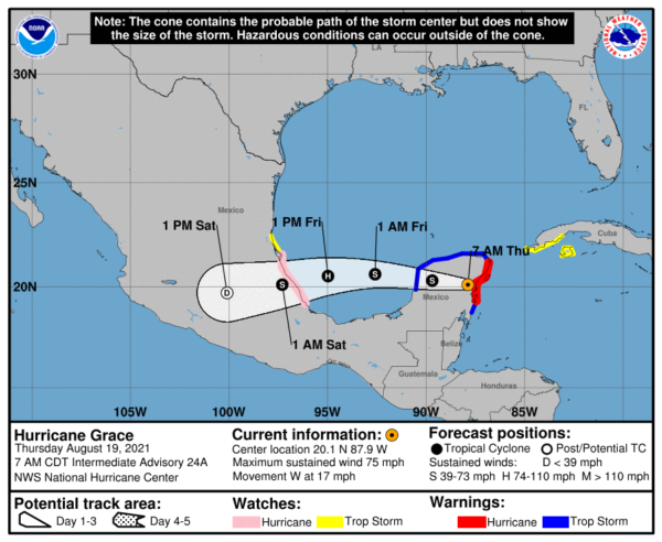
7 am Advisory — Grace Moving Inland Over the Yucatan Peninsula
SUMMARY OF 7 AM CDT INFORMATION
LOCATION…20.1N 87.9W
ABOUT 45 MI…70 KM SSE OF VALLADOLID MEXICO
MAXIMUM SUSTAINED WINDS…75 MPH…120 KM/H
PRESENT MOVEMENT…W OR 280 DEGREES AT 17 MPH…28 KM/H
MINIMUM CENTRAL PRESSURE…989 MB…29.20 INCHES
WATCHES AND WARNINGS
A Hurricane Warning is in effect for…
* Yucatan Peninsula of Mexico from Cancun to Punta Herrero, including Cozumel
A Hurricane Watch is in effect for…
* The coast of mainland Mexico from Puerto Veracruz to Cabo Rojo
A Tropical Storm Warning is in effect for…
* Yucatan Peninsula of Mexico from north of Cancun to Campeche
* Yucatan Peninsula of Mexico from south of Punta Herrero to Puerto Costa Maya
A Tropical Storm Watch is in effect for…
* Southern coast Cuban province of Pinar del Rio, as well as Isla de la Juventud
* The coast of mainland Mexico north of Cabo Rojo to Puerto de Altamira
FORECAST DISCUSSION
At 700 AM CDT (1200 UTC), the center of Hurricane Grace was located near latitude 20.1 North, longitude 87.9 West. Grace is moving toward the west near 17 mph (28 km/h). A general westward to west-northwestward motion is expected through Friday, followed by a general westward to west-southwestward motion. On the forecast track, Grace is expected to move across the Yucatan Peninsula today, and move over the southwest Gulf of Mexico late tonight through Friday. The hurricane will likely make a second landfall on the mainland coast of Mexico late Friday or early Saturday.
Maximum sustained winds have decreased to 75 mph (120 km/h) with higher gusts. Grace is expected to continue to weaken as it crosses Yucatan, but re-intensification is expected when the center reaches the Gulf of Mexico. Grace is expected to be a hurricane when it makes its second landfall on the mainland coast of Mexico.
Hurricane-force winds extend outward up to 35 miles (55 km) from the center and tropical-storm-force winds extend outward up to 140 miles (220 km). A Weatherflow station located at Cancun, Mexico, recently measured a gust to 67 mph (108 km/h) and another Weatherflow site at Xcaret measured a gust to 57 mph (92 km/h). The Cancun Airport reported a gust to 60 mph (97 km/h).
The estimated minimum central pressure is 989 mb (29.20 inches).
HAZARDS TO LAND
WIND: Hurricane conditions are expected to continue within the warning area in the Yucatan Peninsula of Mexico during the next hour or two and are spreading inland. Tropical storm conditions will continue this morning along the coast and will spread across the rest of the northern Yucatan Peninsula today. Hurricane conditions are possible in the hurricane watch area in mainland Mexico by late Friday, and tropical storm conditions are possible in the tropical storm watch area in mainland Mexico by late Friday. Tropical storm conditions are possible along the southern coast of Cuba within the watch area for the next several hours.
RAINFALL: Grace is expected to produce the following rainfall amounts:
Over north-central portions of the Yucatan Peninsula… 4 to 8 inches of rain with isolated maximum totals of 12 inches are expected through Friday. Heavy rainfall from Grace will likely result in areas of flash and urban flooding.
Over central to northern Veracruz, northern Puebla and into Hidalgo… 5 to 10 inches of rain with isolated maximum totals of 15 inches are expected from Friday through Sunday. Heavy rainfall from Grace will likely result in areas of flash and urban flooding, and will also be capable of producing mudslides.
STORM SURGE: A dangerous storm surge will raise water levels by as much as 3 to 5 ft above normal tide levels along the immediate coast near and to the north of where the center made landfall in the northeastern Yucatan Peninsula, and along the eastern mainland coast of Mexico Friday night or early Saturday. Near the coast, the surge will be accompanied by large and destructive waves.
SURF: Swells generated by Grace will spread westward from Jamaica and the Cayman Islands to the southern coast of Cuba and the Yucatan Peninsula of Mexico through today. These swells are likely to cause life-threatening surf and rip current conditions. Please consult products from your local weather office.
Category: ALL POSTS, Severe Weather, Tropical


