Midday Nowcast: Radar is Active
A weak upper trough is in place across the state, bringing colder air aloft, which is promoting higher rain chances across the state today. Shower and storms have been ongoing this morning, and these continue to increase in coverage as we head into the afternoon hours and they are producing heavy rainfall and lots of lightning.
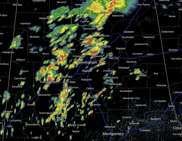
Scattered to numerous showers and thunderstorms are in the forecast the rest of today, tomorrow, and Saturday. Rain is possible at anytime, but the greatest coverage will occur during the afternoon and evening hours. Rainfall will be be heavy at times and some areas of flash flooding are possible and also, some strong storms cannot be ruled out. Highs for North/Central Alabama through Saturday will be in the mid to upper 80s.
FOOTBALL FORECAST: For the high school football games across Alabama tonight and tomorrow night, a passing shower or thunderstorm is possible both nights in a few scattered places. Unfortunately with summer storms there is no way of knowing in advance exactly when and where they form; you just have to watch radar trends. And, when you hear thunder, get out of the stands and indoors or into a vehicle. Temperatures at kickoff time will be in the low 80s at most stadiums.
HEAT LEVELS ON THE RISE: By Sunday the upper ridge begins to intensify over the Deep South causing our weather to trend hotter and drier. From Sunday through at least the middle of next week, the forecast features mainly sunny and hot weather with highs in the low and mid 90s. Heat index values will likely be over 100°, and may approach the 105° Heat Advisory criteria at times. Also, afternoon/evening showers and storms will remain rather isolated.
IN THE TROPICS: We have two tropical storms currently, Grace and Henri…thankfully, neither is a threat to Alabama nor the Northern Gulf Coast.
GRACE: Made landfall as a hurricane this morning, but has weekend some…The center of Tropical Storm Grace was located near latitude 20.2 North, longitude 88.8 West. Grace is moving toward the west near 18 mph. A general westward to west-northwestward motion is expected today, followed by a general westward to west-southwestward motion at a slower speed over the weekend. On the forecast track, Grace is expected to continue to move across the Yucatan Peninsula today, and move over the southwest Gulf of Mexico late tonight through Friday. Grace will likely make a second landfall on the mainland coast of Mexico late Friday or early Saturday.
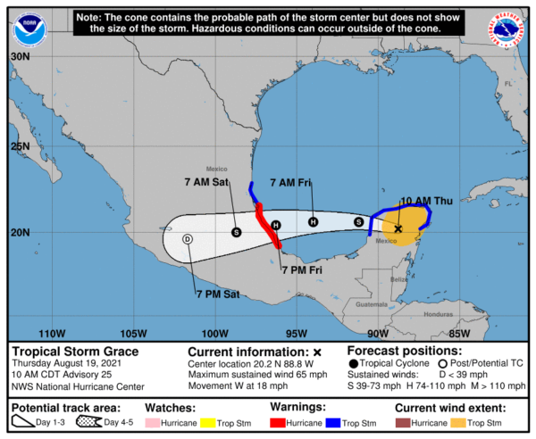
Maximum sustained winds have decreased to near 65 mph with higher. Additional weakening is possible while Grace moves across land today. Re-intensification is likely after the center reaches the Gulf of Mexico. Grace is forecast to be a hurricane when it makes its second landfall on the mainland coast of Mexico late Friday or early Saturday. Rapid weakening is expected after Grace moves inland over central Mexico. Tropical-storm-force winds extend outward up to 140 miles from the center. The estimated minimum central pressure is 994 mb (29.36 inches).
HENRI: The center of Tropical Storm Henri was located near latitude 29.5 North, longitude 70.5 West. Henri is moving toward the west near 10 mph and this motion is expected to continue through tonight. A turn toward the northwest is forecast on Friday, followed by an acceleration toward the north and north-northeast Saturday and Sunday. On the forecast track, the center of Henri will remain well offshore of the east coast of the United States over the next couple of days, but it is forecast to be near southern New England on Sunday and Monday.
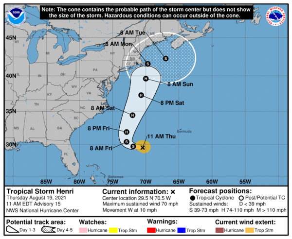
Maximum sustained winds remain near 70 mph with higher gusts. Little change in strength is expected today, but Henri is forecast to intensify into a hurricane on Friday with additional strengthening predicted to occur this weekend. Tropical-storm-force winds extend outward up to 80 miles from the center. The estimated minimum central pressure is 995 mb (29.39 inches).
BEACH FORECAST CENTER: Get the latest weather and rip current forecasts for the beaches from Fort Morgan to Panama City on our Beach Forecast Center page. There, you can select the forecast of the region that you are interested in visiting.
CONTIGUOUS TEMPERATURE EXTREMES: Over the last 24 hours, the highest observation was 109F at Stovepipe Wells, CA. The lowest observation was 29F at Bodie, CA.
WEATHER ON THIS DATE IN 1788: A small but powerful hurricane inflicted great havoc upon forests along a narrow track from New Jersey to Maine. A similar storm track today would cause extreme disaster in the now populated area.
Category: Alabama's Weather, ALL POSTS
About the Author (Author Profile)
Macon, Georgia Television Chief Meteorologist, Birmingham native, and long time Contributor on AlabamaWX. Stormchaser. I did not choose Weather, it chose Me. College Football Fanatic. @Ryan_StinnetSubscribe
If you enjoyed this article, subscribe to receive more just like it.


