10 am Advisory — Henri Remains a Tropical Storm, Forecast to be a Hurricane on Saturday
SUMMARY OF 10 AM CDT INFORMATION
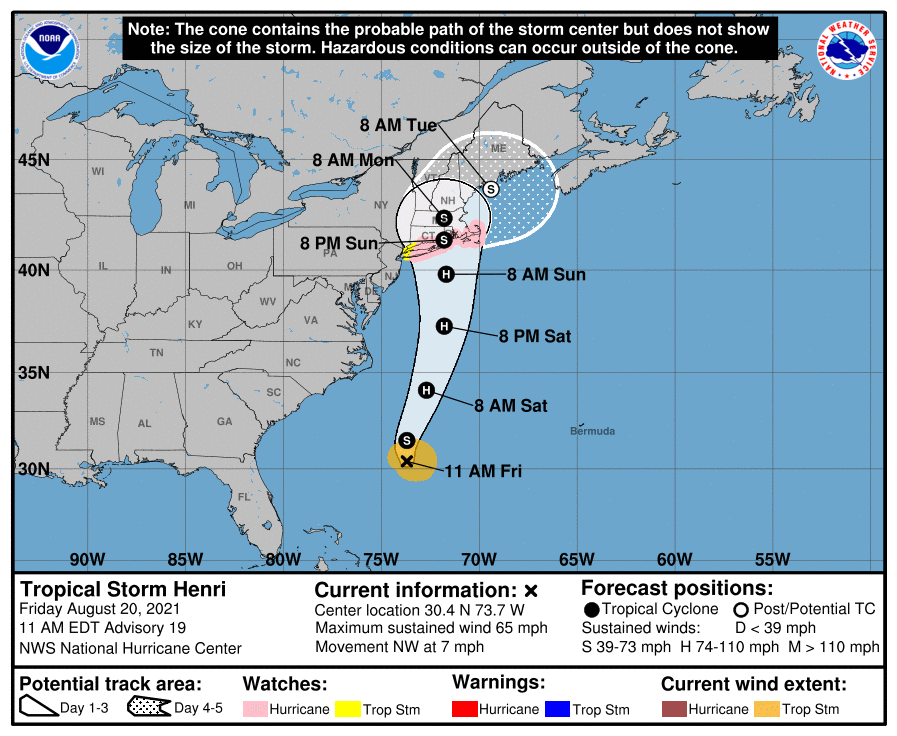
LOCATION…30.4N 73.7W
ABOUT 345 MI…560 KM SSE OF CAPE HATTERAS, NORTH CAROLINA
ABOUT 745 MI…1200 KM S OF MONTAUK POINT, NEW YORK
MAXIMUM SUSTAINED WINDS…65 MPH…100 KM/H
PRESENT MOVEMENT…NW OR 305 DEGREES AT 7 MPH…11 KM/H
MINIMUM CENTRAL PRESSURE…996 MB…29.42 INCHES
WATCHES AND WARNINGS
A Storm Surge Watch is in effect for…
* South Shore of Long Island from East Rockaway Inlet to Montauk
* North Shore of Long Island from King’s Point to Montauk
* Flushing, New York to Sagamore Beach, Massachusetts
* Nantucket, Martha’s Vineyard, and Block Island
A Hurricane Watch is in effect for…
* South Shore of Long Island from Fire Island Inlet to Montauk
* North Shore of Long Island from Port Jefferson Harbor to Montauk
* New Haven, Connecticut to Sagamore Beach, Massachusetts
* Nantucket, Martha’s Vineyard, and Block Island
A Tropical Storm Watch is in effect for…
* West of Fire Island Inlet to East Rockaway Inlet, New York
* West of Port Jefferson Harbor, New York
* West of New Haven, Connecticut
FORECAST DISCUSSION
The Air Force Reserve Hurricane Hunters investigated Henri this morning and based on the flight-level, SFMR, and dropsonde data, the initial intensity is still around 55 kt. The minimum pressure has also been relatively steady. The low-level center of Henri is located close to the northwestern edge of the main area of deep convection, and the vortex is still not vertically aligned due to 20-25 kt of northerly vertical wind shear. Although the intensity of Henri has not changed much during the past couple of days, satellite images show an improving cloud pattern with well-established outflow in the eastern semicircle, which could indicate that Henri is poised to strengthen.
There is some uncertainty in the exact position of Henri given the recent aircraft fixes and the tilt of the vortex, but the initial motion appears to be northwestward at 6 kt. A trough over the central Appalachians is expected to cut off tonight, and the combination of that feature and a building ridge to the east/northeast of Henri should cause the storm to turn northward tonight and accelerate in that direction on Saturday. Some of the models show a slight bend to the west around the time Henri is forecast to make landfall on Sunday, and there remains a fair amount spread in the guidance in where the center of Henri will come ashore. The latest GFS and ECMWF ensemble members span a region from near New York City to Cape Cod for the landfall point. Based on the latest consensus aids and initial position, the official track forecast is nudged to the west of the previous one and shows landfall occurring by late Sunday. After day 3, Henri is forecast to eject northeastward across the Gulf of Maine.
The ongoing northerly shear is expected to decrease later today, and the global models show a favorable upper-level wind pattern developing over the storm later today through the weekend. These more conducive atmospheric conditions combined with the warm Gulf Stream waters should allow Henri to strengthen to a hurricane tonight or early Saturday, with additional intensification expected into Saturday night. By early Sunday, however, Henri is forecast to cross the north wall of the Gulf Stream, and that should end its opportunity for strengthening. Although steady to rapid weakening is forecast while Henri moves over cooler waters south of New England, it will likely still be at or very near hurricane intensity when it reaches the coast. Post-tropical transition is forecast to occur in 3 to 4 days, and the new forecast shows Henri dissipated by day 5, in agreement with most of the global models.
Users are reminded to not focus on the exact forecast of the center of Henri, since impacts will extend far from the center.
KEY MESSAGES
1. Dangerous storm surge inundation and hurricane conditions are possible beginning Sunday in portions of Long Island, Connecticut, Rhode Island, and southeastern Massachusetts, where a Storm Surge Watch and Hurricane Watch are in effect. Residents in these areas should follow any advice given by local officials.
2. Heavy rainfall may lead to flash, urban, and small stream flooding, along with the potential for widespread minor and isolated moderate river flooding, over portions of southern New England Sunday into Monday.
3. Swells from Henri will begin to reach much of the east coast of the U.S. and Atlantic Canada by the end of the week and continue through the weekend. These swells could cause life-threatening surf and rip currents.
Category: ALL POSTS, Severe Weather, Tropical
About the Author (Author Profile)
Scott Martin is an operational meteorologist, professional graphic artist, musician, husband, and father. Not only is Scott a member of the National Weather Association, but he is also the Central Alabama Chapter of the NWA president. Scott is also the co-founder of Racecast Weather, which provides forecasts for many racing series across the USA. He also supplies forecasts for the BassMaster Elite Series events including the BassMaster Classic.Subscribe
If you enjoyed this article, subscribe to receive more just like it.


