10 am Advisory — Grace Expected to Continue Strengthening
SUMMARY OF 10 AM CDT INFORMATION
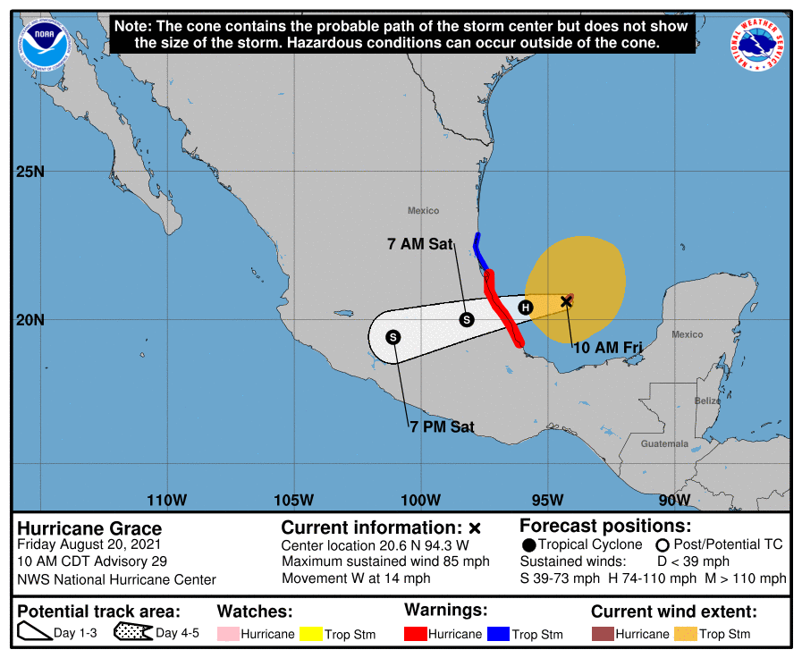
LOCATION…20.6N 94.3W
ABOUT 200 MI…325 KM E OF TUXPAN, MEXICO
ABOUT 155 MI…250 KM NE OF VERACRUZ, MEXICO
MAXIMUM SUSTAINED WINDS…85 MPH…140 KM/H
PRESENT MOVEMENT…W OR 265 DEGREES AT 14 MPH…22 KM/H
MINIMUM CENTRAL PRESSURE…982 MB…29.00 INCHES
WATCHES AND WARNINGS
A Hurricane Warning is in effect for…
* The coast of mainland Mexico from Puerto Veracruz to Cabo Rojo
A Tropical Storm Warning is in effect for…
* The coast of mainland Mexico from north of Cabo Rojo to Barra del Tordo
FORECAST DISCUSSION
Grace is a strengthening tropical cyclone. Its structure has continued to improve in satellite imagery this morning, with more pronounced curved banding in its northern and eastern semicircles and good upper-level outflow. An Air Force Reserve Hurricane Hunter aircraft measured a peak 850-mb flight-level wind of 92 kt and peak SFMR winds of 74 kt during a pass through the northeast quadrant earlier this morning. These data support increasing the initial intensity to 75 kt, which makes Grace a hurricane once again. Dropsonde data from the aircraft indicate the minimum pressure has fallen to 982 mb.
The warm waters of the Bay of Campeche are expected to support additional intensification through landfall in mainland Mexico later this evening or tonight, despite some light to moderate northerly wind shear. Since the reconnaissance data revealed Grace is strengthening quicker than previously forecast, the official NHC intensity forecast was increased in the short-term. Grace is now forecast to become a 90-kt hurricane in 12 h, which lies on the high end of the intensity guidance. The center of Grace will be well inland by 24 h, and rapid weakening is forecast thereafter as the cyclone moves over the mountains of central Mexico. Although Grace is forecast to dissipate by 48 h, its remnants will likely move into the eastern Pacific and lead to the development of a new tropical cyclone later this weekend or early next week.
The cyclone is moving just south of due west, or 265/12 kt. Grace should continue moving westward to west-southwestward through landfall, to the south of a mid-level ridge over the northern Gulf of Mexico. The official NHC track forecast remains near the middle of the guidance envelope and has been adjusted just a bit southward based on the latest multi-model consensus aids.
KEY MESSAGES
1. Hurricane conditions and dangerous storm surge are likely along portions of eastern mainland Mexico beginning late today, within the Hurricane Warning area from Puerto Veracruz northward to Cabo Rojo.
2. Through the weekend, heavy rainfall across Veracruz, Puebla, Tlaxcala, Hidalgo, northern Querétaro, and eastern San Luis Potosí will lead to flash and urban flooding, along with the likelihood of mudslides.
Category: ALL POSTS, Severe Weather, Tropical
About the Author (Author Profile)
Scott Martin is an operational meteorologist, professional graphic artist, musician, husband, and father. Not only is Scott a member of the National Weather Association, but he is also the Central Alabama Chapter of the NWA president. Scott is also the co-founder of Racecast Weather, which provides forecasts for many racing series across the USA. He also supplies forecasts for the BassMaster Elite Series events including the BassMaster Classic.Subscribe
If you enjoyed this article, subscribe to receive more just like it.


