Midday Nowcast: Some Showers, More on the Way
ABOVE AVERAGE RAIN CHANCES: Today and tomorrow, scattered to numerous showers and thunderstorms are in the forecast, and these could continue into the forecast Sunday as well, especially for areas across South Alabama. Rain is possible at anytime, but the greatest coverage will occur during the afternoon and evening hours.
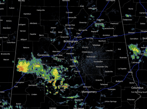
Areas of rain are ongoing late this morning, and these will continue to expand in coverage the rest of today. Rainfall will be heavy at times and some areas of flash flooding are once again possible due to the very tropical air mass in place. Also, some strong storms cannot be ruled out. Highs, due to the clouds and rain should hold in the 80s. By Sunday, an upper ridge begins to build in and rain chances will start to decrease, also, highs should climb into the lower 90s.
FOOTBALL FORECAST: For the high school football games across Alabama tonight, some showers and storms are possible, so take the rain gear to be safe. Unfortunately with summer storms, there is no way of knowing in advance exactly when and where they form; you just have to watch radar trends. And, when you hear thunder, get out of the stands and indoors or into a vehicle. Temperatures at kickoff time will be in the low 80s at most stadiums.
HOT START TO WEEK: As the upper ridge begins to intensify over the Deep South, the new work week will start off mainly sunny and hot weather with highs in the low and mid 90s. Heat index values will likely be over 100°, and afternoon/evening showers and storms will remain rather isolated. By the second half of the week, the ridge looks to weaken some, so highs should fall back closer to 90° with a few more storms across Alabama each day.
IN THE TROPICS: We have two tropical system currently, Hurricane Grace and Henri…
HURRICANE GRACE: Grace regained hurricane intensity this morning. the center of Hurricane Grace was located near latitude 20.6 North, longitude 94.3 West. Grace is moving toward the west near 14 mph. This general motion at a slightly slower forward speed is expected during the next day or so. On the forecast track, the center of Grace is forecast to move across the southwestern Gulf of Mexico this afternoon, and then make landfall along the coast of mainland Mexico within the hurricane warning area this evening or tonight.
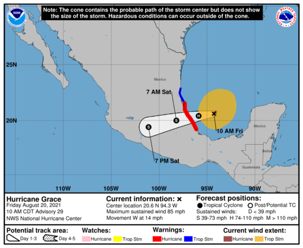
Data from an Air Force Reserve Hurricane Hunter aircraft indicate that maximum sustained winds are near 85 mph with higher gusts. Strengthening is forecast until Grace makes landfall, with rapid weakening expected as Grace moves inland over the mountains of central Mexico. Hurricane-force winds extend outward up to 30 miles from the center and tropical-storm-force winds extend outward up to 185 miles. The estimated minimum central pressure is 982 mb (29.00 inches) is based on data collected by the aircraft.
HENRI: The center of Tropical Storm Henri was located near latitude 30.4 North, longitude 73.7 West. Henri is moving toward the northwest near 7 mph. A turn toward the north is expected by tonight, and Henri is forecast to accelerate in that direction through early Sunday. On the forecast track, Henri is expected to make landfall in southern New England by late Sunday.
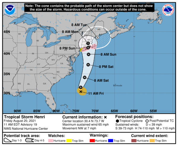
Maximum sustained winds are near 65 mph with higher gusts. Strengthening is forecast during the next couple of days, and Henri is expected to become a hurricane by Saturday and be at or near hurricane strength when it makes landfall in southern New England. Tropical-storm-force winds extend outward up to 90 miles from the center. The estimated minimum central pressure based on data from the Air Force Hurricane Hunters is 996 mb (29.42 inches).
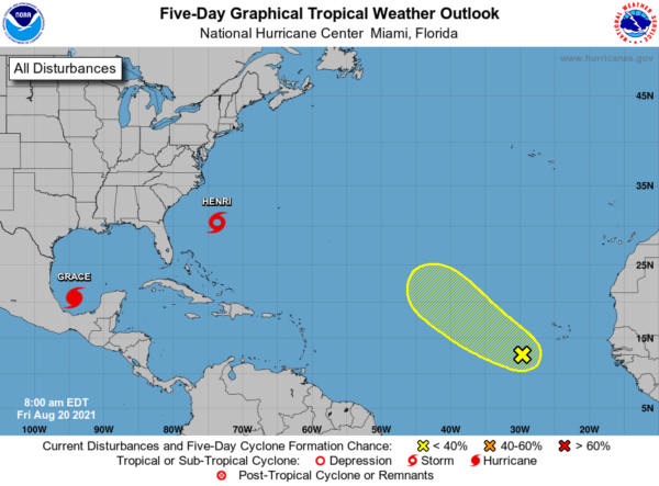
Also, one other feature way out in the Atlantic…A tropical wave located over the eastern Atlantic several hundred miles to the southwest of the Cabo Verde Islands is producing a broad area of disorganized showers and thunderstorms. This wave is expected to interact with another wave emerging off the African coast over the next day or two. Afterwards, environmental conditions appear marginally favorable for some slow development by the beginning of next week as this system moves gradually to the northwest at 5 to 10 mph. Formation chance through 5 days…low…20 percent.
Next name up is Ida..
BEACH FORECAST CENTER: Get the latest weather and rip current forecasts for the beaches from Fort Morgan to Panama City on our Beach Forecast Center page. There, you can select the forecast of the region that you are interested in visiting.
WORLD TEMPERATURE EXTREMES: Over the last 24 hours, the highest observation outside the U.S. was 115.3F at Sulaibiya, Kuwait. The lowest observation was -93.3F at University Dome, Antarctica.
CONTIGUOUS TEMPERATURE EXTREMES: Over the last 24 hours, the highest observation was 107F at Falcon Lake, TX. The lowest observation was 25F at Bridgeport, CA.
WEATHER ON THIS DATE IN 1910: The big blow up of forest fires finally came to an end in Idaho. A record dry August fueled 1736 fires which burned three million acres destroying six billion board feet of timber. The fires claimed the lives of 85 persons, 78 of which were fire fighters, and consumed the entire town of Wallace. The smoke spread a third of the way around the world producing some dark days in the U.S. and Canada. The forest fires prompted federal fire protection laws.
Category: Alabama's Weather, ALL POSTS
About the Author (Author Profile)
Macon, Georgia Television Chief Meteorologist, Birmingham native, and long time Contributor on AlabamaWX. Stormchaser. I did not choose Weather, it chose Me. College Football Fanatic. @Ryan_StinnetSubscribe
If you enjoyed this article, subscribe to receive more just like it.


